cbmclean
-
Posts
3,331 -
Joined
-
Last visited
Content Type
Profiles
Blogs
Forums
American Weather
Media Demo
Store
Gallery
Everything posted by cbmclean
-
I was wondering what you thought of the Pedersen firing.
-
Feb Long Range Discussion (Day 3 and beyond) - MERGED
cbmclean replied to WinterWxLuvr's topic in Mid Atlantic
Thanks for the analysis. I suspected that it was likely not a reproducible pattern but in desperation I'm looking for anything which might possibly "work". Speaking of the Pac Jet, you have mentioned that our choice is to have it either pointed at us, with the result being a Pac puke torch, or else at Canada, with the result that our source region torches. Is there no configuration which leads to it being pointed to the southeast, like at Mexico? You have never mentioned that as a possibility so I am assuming its not feasible, but I was wondering why. -
Feb Long Range Discussion (Day 3 and beyond) - MERGED
cbmclean replied to WinterWxLuvr's topic in Mid Atlantic
We got a few inches of snow down here towards the end of the pattern which is enough to satisfy us for the most part. The fresh snow cover was what allowed me to hit 0 °F. Then the pattern shifted and we torched for the rest of the January and all of February. March was chill though as you guys surly remember. -
Feb Long Range Discussion (Day 3 and beyond) - MERGED
cbmclean replied to WinterWxLuvr's topic in Mid Atlantic
I haven't been since last year right before COVID hit, but to my knowledge they are still going strong. They did get in trouble due to some COVID compliance issues back in the fall. https://www.witn.com/2020/09/29/coronavirus-guideline-violations-reported-at-parkers-in-wilson/ -
Feb Long Range Discussion (Day 3 and beyond) - MERGED
cbmclean replied to WinterWxLuvr's topic in Mid Atlantic
Ponds froze over and I hit 0 °F in Wilson NC, which is in the coastal plain. That is amazing for here. Back then I had even less knowledge of global weather patterns than I do now, so I wasn't really paying attention to what was driving the cold. Now I want to understand. -
Feb Long Range Discussion (Day 3 and beyond) - MERGED
cbmclean replied to WinterWxLuvr's topic in Mid Atlantic
The last significant cold outbreak I remember in my neck of the woods US was late December 2017/early January 2018. Not much snow up you guys way but it was 2 weeks of solid cold. I am assuming that it was Pacific driven. I took a look at the 500HP anomalies from that period and it didn't really make sense to me. Would you be interested in analyzing that period to see what was going on? -
That is a valid point, but I if I understand correctly, I think the negativity in the main thread currently is due to a notable degradation in the outlook across all three "majors" (GFS, Euro, CMC) during the course of several consecutive runs. I think its completely legitimate to be discouraged right now.
-
I have to disagree. When the model guidance is good, PSU says so. When it is bad he is sometimes discouraged as are we all. Right now guidance is bad or at least clearly trending the wrong way. Ji on the other hand...
-
Feb Long Range Discussion (Day 3 and beyond) - MERGED
cbmclean replied to WinterWxLuvr's topic in Mid Atlantic
So is the Pacific Jet retraction cancelled? -
Feb Long Range Discussion (Day 3 and beyond) - MERGED
cbmclean replied to WinterWxLuvr's topic in Mid Atlantic
Assuming this wave goes down in flames, what is your assessment of general potential in days beyond (d10 -16)? -
Feb Long Range Discussion (Day 3 and beyond) - MERGED
cbmclean replied to WinterWxLuvr's topic in Mid Atlantic
Anyone know what the Pacific jet is up to? Last I saw it was forecast to significantly retract, which is crucial to our hopes for cold. -
Last year there was a brief period where the modeling consistently advertised a significant improvement from the Pacific Doom Blob regime. I remember distinctly that this modeled improvement started to fall apart jast as the Ravens were losing to Tennessee last year. At the time I was hoping that the negative interpretation of the modelling had a lot to do with the emotions from the game. But alas it was not the case. The look continued to degrade over the next few days and the rest is history. Hopefully we don;t get a redux this year.
-
Saw tiny snowflakes for about 30 seconds in Wilson.
-
I wondered why it was so quiet in the main thread. Then I remembered the Ravens are playing.
-
Feb Long Range Discussion (Day 3 and beyond) - MERGED
cbmclean replied to WinterWxLuvr's topic in Mid Atlantic
Wait isn't the "old Para" the current GFS? -
Feb Long Range Discussion (Day 3 and beyond) - MERGED
cbmclean replied to WinterWxLuvr's topic in Mid Atlantic
I'm a chart guy, so for fun, I plotted the "near DC" 2m temp at 18Z for hours 0 - 384, according to the 18z gfs. Decently chilly for days 7 - 14. Not sure what happens between 336 and 360, but it wasn't pretty.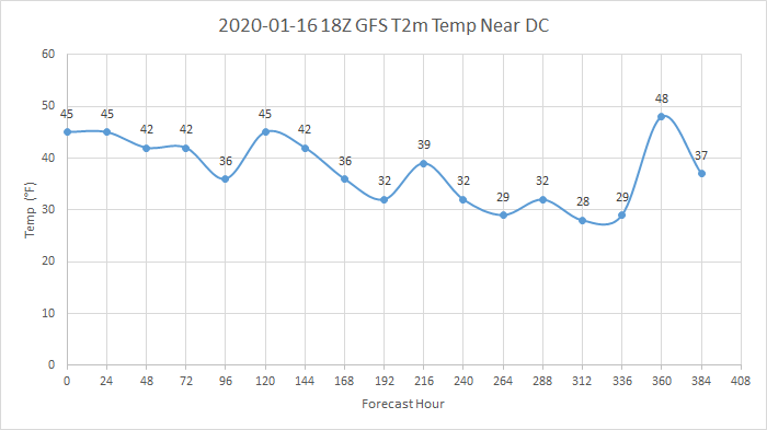
-
Feb Long Range Discussion (Day 3 and beyond) - MERGED
cbmclean replied to WinterWxLuvr's topic in Mid Atlantic
We need a Canadian Maritimes subforum on here. -
Feb Long Range Discussion (Day 3 and beyond) - MERGED
cbmclean replied to WinterWxLuvr's topic in Mid Atlantic
Hey I'm the epicenter. I'm all in. -
Feb Long Range Discussion (Day 3 and beyond) - MERGED
cbmclean replied to WinterWxLuvr's topic in Mid Atlantic
That goes out past where I can see on TT. What does the temp profile look like? -
Hey, been waiting for you to show up. Turn those Shields off!!!
-
Feb Long Range Discussion (Day 3 and beyond) - MERGED
cbmclean replied to WinterWxLuvr's topic in Mid Atlantic
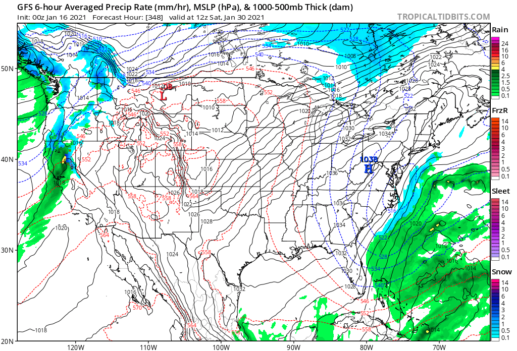
Too suppressed even for NC. This panel caught my eye though: 540 line down almost to Miami, and snow breaking out over the gulf stream.
-
Gotta love this one. 540 line down almost to Miami.
-
Feb Long Range Discussion (Day 3 and beyond) - MERGED
cbmclean replied to WinterWxLuvr's topic in Mid Atlantic
Curious, why is that a "lol"? -
Not much going on for at least the next week, unless I missed something new.