cbmclean
-
Posts
3,033 -
Joined
-
Last visited
Content Type
Profiles
Blogs
Forums
American Weather
Media Demo
Store
Gallery
Everything posted by cbmclean
-
Assuming of course that this happens. What is your current take on that? Looking at the 18Z GEFS I see a nice cool shot (at 850 MB at least) after the 16th, then the cold really gathers in NW Canada. Although we are by no means torching, its just seasonal to coolish by day 16.
-
We need to set a rotation schedule for someone to check on Ji at least daily.
-
Thanks. This is a start at least. Now we need a mechanism to get this moving east.
-
Well if snow is a unicorn now, we have two choices: we can pack it in or we can become unicorn hunters. It seems likely that hunting for discrete threats is pointless until and unless the NA thermal profile changes. What is the status of that? TT is taking forever to finish loading the 18Z GEFS. Is the Canadian torch still scheduled for demolition? Has anyone seen on the the pay sites yet?
-
All right then I think that just about sums it up. If these suspicions are correct, then we have tough times ahead of us as snow lovers in eastern NA.
-
Fair enough. So let's analyze why sufficient cold air has not been available. First suspect is of course the NPAC vortex. But as PSU has pointed out, that vortex has been present in past analogs that have been "cold enough". What's different now? Well the elephant in the room is the warmer base state of course, which can explain a lot. But gosh darn it, its not like there hasn't been any cold anomalies in the NH. It's just all been stuck in Eurasia. So that is what I want to understand? WHY has it been stuck in Eurasia?
-
Kind of a rhetorical/philosophical question, but we're in between model runs so why not: can you really call it a decent/good pattern if there is not enough cold air to sustain widespread snow? The presence or absence of cold air isn't just a random factor, it's a facet of the overall NH pattern. And I completely understand what you have posted several times about much of the MA historical snow coming in similar patterns in the past but clearly those patterns had cold enough air and this one has not, at least up to this point. So I think it is fair to call it a "bad" pattern.
-
I love it when the fullback makes a catch.
-
Boo hiss
-
Trying to understand cyclogenesis better. If anyone else on here like me who knows very little about it, I found a very nice youtube video discussing the topic. with really nice 3D diagrams that make terms like "cold conveyor belt" make more sense to the layman.
-
Ah thanks...so much to learn.
-
On this plot what indicates "energy"? I am used to seeing people refer to "energy" when they are talking about areas of enhanced vorticity on vorticity maps, but I don't see what you are referring to on this map.
-
Eerily quiet around here.
-
If you are feeling didactic tonight, what exactly is a "transfer"? I only have the vaguest idea of storm dynamics.
-
What was the WeatherMachine?
-
Just curious how much impact you think the hostile November had. You have mentioned it a few times as a negative factor, but was it a MAJOR factor?
-
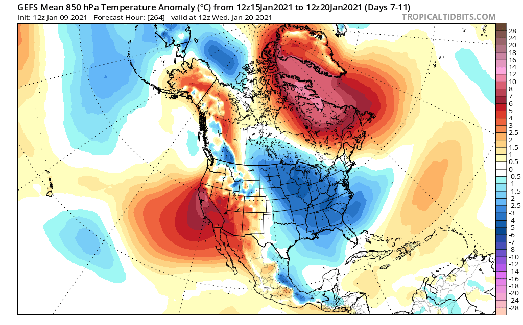
GEFS 850 MB temp anomalies still look to improve considerably after Jan 16, both for us and for our source region. 2m anomalies are disappointing though.

-
I am considering a project to amuse me and perhaps improve my coding and weather skills. I would really like to keep track of the various ensemble predictions for temperatures as they change day to day. Does anyone know where I can access numerical data for GEFS temperature outputs for a specific weather station from day 1 to Day 15? I would love to have all the ensemble members available so I could plot a mean and a spread.
-
Oddly enough it been seasonal or maybe slightly below down here in NC. This has me mostly happy because 10 days ago it looked like a pure torch for us.
-
I am considering a project to amuse me and perhaps improve my coding and weather skills. I would really like to keep track of the various ensemble predictions for temperatures as they change day to day. Does anyone know where I can access numerical data for GEFS temperature outputs for say RDU from day 1 to Day 15? I would love to have all the ensemble members available so I could plot a mean and a spread.
-
Given the NA temp anomalies since November I'd be surprised if there is anywhere in the US where the snow is "good" compared to their climo. Unless its some mountain area where they are getting more moisture than usual.
-
20210109 12Z updates 12Z GEFS 12Z EPS Day1 - 5 3 3 Day 6 - 10 5 5 Day 11-15 8 2
-
I don't have access to any of the pay sites so I just have TT and they didn't have the 12Z yet, so I wasn't in on it. My heart sank. Now its back on life support.
-
Honest question, who could you possibly be driving nuts with this? If one is not interested in discussions like that, why would they be here? I'm honestly perplexed.
-
Heard on the MA forum that 00Z EPS is disastrous past about Day 7. 06Z GEFS looked great, but someone said 12Z caved to the EPS. Still awaiting confirmation.