cbmclean
Members-
Posts
3,283 -
Joined
-
Last visited
Content Type
Profiles
Blogs
Forums
American Weather
Media Demo
Store
Gallery
Everything posted by cbmclean
-
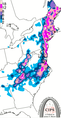
I think one reason is the way it hit NC (we got ~13" in Wilson NC which is like 3 years' average in one storm), NJ, NY and New England, but managed stiff the heart of this forum.
-
3/12 Event: Winters Last Hurrah at Least East of Mountains
cbmclean replied to Weather Will's topic in Mid Atlantic
What is your seasonal total? This should help a bit. -
I clearly remember @psuhoffman guaranteed a 1993 redux this winter so I am taking to the bank!
-
That looks phishy.
-
Excellent post. I always love to see you post in here, as the posts are info-filled and never random hype or downerism. This is actually a nice change of pace. We are usually left to try and analyze why a modelled good pattern suddenly degrades, so to see a bad pattern "degrade" is a treat. Of course for my actual forum (the SE) this probably just means the difference between warm rain and cold rain, but I am rooting for the MA and especially the NW crew to cash in.
-
What is a CF?
-
For me, that is one of the big positives from this year. Assuming the pattern does break down after Valentines that would be a solid 5 - 6 weeks of "workable to good" Pacific, which feels like it might be more than the "workable to good" time than the previous five winters put together. On the negative side, it seems like the "trend" of the complete inability to have the Atlantic and Pacific to play nicely together for any extended time is continuing. I'm not talking about having both sides be really good at the same time; that's rarer than finding a unicorn with a four leaf clover growing out of its butt. I'm just talking about one side being good while the other is at least workable. The present day default state is that if one side is good the other side is a raging dumpster fire and if the raging dumpster fire by chance goes out, it immediately pops up on the other side.
-
You are not mistaken. We also had -NAO for a good part of this past December. Unfortunately in both cases it was largely rendered moot by Pac Puke.
-
I don't discount long range cold totally, but I do tend to put more credence in long range warm. I think this is rational as it us my understanding that the models have a known cold bias in the medium to long range, so if they are showing a warm signal, then I think it is more likely that there is a strong feature which is overcoming their bias.
-
@psuhoffman sure has been pretty quiet lately. Pretty rude of him to let family and work responsibilities get in the way of posting to keep me informed.
-
Late January and February Medium/Long Range Discussion
cbmclean replied to WinterWxLuvr's topic in Mid Atlantic
Question: what is a "plume"?- 4,130 replies
-
- prime climo
- cold canada
-
(and 1 more)
Tagged with:
-
Late January and February Medium/Long Range Discussion
cbmclean replied to WinterWxLuvr's topic in Mid Atlantic
Icon hates us. A new dr no Doctor Nein?- 4,130 replies
-
- 1
-

-
- prime climo
- cold canada
-
(and 1 more)
Tagged with:
-
Someone in the NE thread just claimed that Bos just hit its all time one day snow record. Not sure if that is accurate or not. if so that would be impressive.
-
Late January and February Medium/Long Range Discussion
cbmclean replied to WinterWxLuvr's topic in Mid Atlantic
Wow is the same storm that was supposed to be a cutter or is this different energy?- 4,130 replies
-
- prime climo
- cold canada
-
(and 1 more)
Tagged with:
-
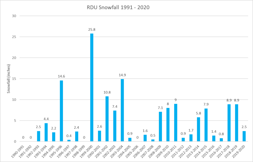
The average is somewhere between 5.1 and 5.2 inches, depending on whether or not you include years that just have a trace. That's true but that isn't really that extraordinary. Looking at the period 1990- 2020, we had Five years in a row below average (1990-1991 through 1994-1995) Four years in a row below average (2004-2005 through 2007 - 2008) Three years in a row below average (1996-1997 through 1998 - 1999) Of the 1990's 8 out of 10 years were below average
-
January 28-29 2022 Miller abcdefu Storm Obs/Discussion
cbmclean replied to mappy's topic in Mid Atlantic
That is truly beautiful. -
Some people seem to get as much or maybe more more joy from others failing to get snow than from their own successes. It is actually quote a common attitude I have found, although I don't understand it myself.
-
I found the numbers and crunched them. The RDU 30 mean for snow is 5.13 inches. The median is only 2.5 inches. So we are already above the median. 60% of years (18 of 30) during this period were below the mean. And if we didn't get any more snow it would only be the third consecutive year below the mean. 2018 - 2019 was well above the mean: 8.9 "
-
I just grabbed the monthly data from here https://www.weather.gov/wrh/climate?wfo=RAH You can also get the GSO data from there as well.
-
I personally find the shotgun/spread revolution less aesthetically pleasing than say the 1990's with fullbacks. The game has swung too much to the offense for my personal taste. Please note that I am just talking about my personal preference. I hate it when people try to argue that their personal likes are objectively superior and their personal dislikes are objectively inferior.
-
Conversely, the 1990s were a dark time.
-
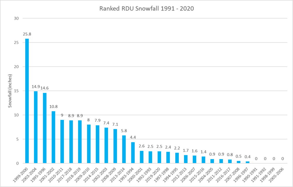
Here is a ranked graph of RDU snowfall from 1991-2020. Note the Carolina crusher sticks out like a beautiful sore thumb.
-
For RDU, the mean for 1981 - 2010 was 6.75 " so when we lost the 1980's our mean went down a good bit. Our median plummeted though. It was 4.25".
-
I will look in a minute, but first I have obtained the yearly snowfall amounts from 1991 - 2020. The median snowfall is......2.5 inches, less than half the mean! So RDU has already exceed its real "normal" snowfall for the year. Congratulations for us all. (note, I treat "T" as zeros in my calculations Here is the yearly data 1990-1991 0 1991-1992 0 1992-1993 2.5 1993-1994 4.4 1994-1995 2.2 1995-1996 14.6 1996-1997 0.4 1997-1998 2.4 1998-1999 0 1999-2000 25.8 2000-2001 2.6 2001-2002 10.8 2002-2003 7.4 2003-2004 14.9 2004-2005 0.9 2005-2006 0 2006-2007 1.6 2007-2008 0.5 2008-2009 7.1 2009-2010 8 2010-2011 9 2011-2012 0.9 2012-2013 1.7 2013-2014 5.8 2014-2015 7.9 2015-2016 1.4 2016-2017 0.8 2017-2018 8.9 2018-2019 8.9 2019-2020 2.5
-
What do you define as normal? For the 1991 - 2020 period, RDU "normal" (mean) is 5.2 inches: 2.6 in Jan, 1.4 in Feb, 0.3 in March, 0.1 in Nov, and 0.8 in December. I haven't been able to find the yearly numbers to calculate a median but I am certain it is significantly less than the mean.


