cbmclean
Members-
Posts
3,277 -
Joined
-
Last visited
Content Type
Profiles
Blogs
Forums
American Weather
Media Demo
Store
Gallery
Everything posted by cbmclean
-
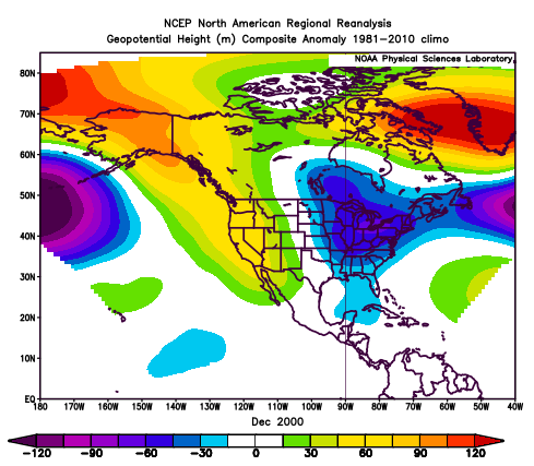
December 2000 will always have a fond place in my memory. HGad just went off to college where I really blossomed after a difficult high school experience. And the late fall/early winter was memorably chilly.
-
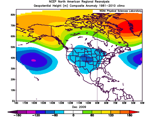
Dec 2009 Quite different. No mean E trough at all. Instead negative anomalies centered over the great plains.
-
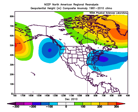
Well start going backwards in time. Dec 2010. Eastern trough is centered rather south compared to the composite and a good bit off shore. No mean western ridge.
-
11 F in Old Fort
-
I'm at the inlaws for Xmas so hopefully I'll have some time to play this evening
-
True, but there is the strong eastern trough signal as well as a weaker but less robust trough off the west coast. I'm just surprised to not see a similar consistent signal in the western conus. The patterns are complex and many-faceted, and sometimes defy easy characterization
-
I was more referring to the lack of positive anomalies in the western CONUS. Surprised to see that with troughing to the east and the west. ETA: I am referring to the bottom composite.
-
Also interesting that the WAR doesn't show up on this year. It just appeared when it counted I guess.
-
Interesting that the strong troughs in the east in the bottom pic are not reflected by a strong ridge in the west. How is that possible?
-
Every model in history has overestimated the speed of cold air going through the mountains. It's just something that has to be manually corrected for. Not sure why they can't get those physics right. But overall this front seems to have been well-modeled from range.
-
The truth shall set us free...free of snow.
-
Anyone with access to the long range EPS, is it showing similar hope, or is it to depressing to even mention?
-
Definite retrograding of the AK vortex. Lets hope this look continues to move forward in time.
-
Looking at the TNH temp correlation, there doesn't seem to be much for the eastern seaboard. Is it something that affects snowfall more than average temperature here?
-
Not very familiar with the TNH teleconnection. Reading up on it a bit at the CPC site. From their write-up its not really clear which phase is better for the eastern CONUS. From https://www.cpc.ncep.noaa.gov/data/teledoc/tnh.shtml The positive phase of the TNH pattern is associated with below-average surface temperatures throughout the western and central United States, and across central and eastern Canada. It is also associated with above-average precipitation across the central and eastern subtropical North Pacific, and below-average precipitation in the western United States and across Cuba, the Bahama Islands, and much of the central North Atlantic Ocean. The negative phase of the TNH pattern is often observed during December and January when Pacific warm (ENSO) episode conditions are present (Barnston et al. 1991). One recent example of this is the 1994/95 winter season, when mature Pacific warm episode conditions and a strong negative phase of the TNH pattern were present. During this period, the mean Hudson Bay trough was much weaker than normal and shifted northeastward toward the Labrador Sea. Additionally, the Pacific jet stream was much stronger than normal and shifted southward to central California, well south of its climatological mean position in the Pacific Northwest. This flow pattern brought well above-normal temperatures to eastern North America and above-normal rainfall to the southwestern United States.
-
Thanks. Seems like puke in is faster than puke out.
-
Can't check ensembles. Anyone know if anymore hints of AK vortex retrograding?
-
Big thunder in Wilson. 0.48" so far.
-
Hopefully the EPO can help replenish the cold air scoured out by the Pac Puke.
-
Consult @Ralph Wiggum for info. He is the WAR Whisperer.
-
Alright. Seems like there is really only one thing to talk about in this thread at the moment: when/if the big AK vortex breaks down/moves. Some of the more level-headed folks have voiced cautious optimism that it may not be excessively long. In between waring with the NE Snow weenies Eric Webber mentioned that he is optimistic because intense waves such as that retrograde due to the "beta effect" whatever that is. So perhaps we have a shot.
-
I know that many gave speculated about next year being a Nino. Has anyone come across any reason to believe it would be a Modoki?
-
Eh, 2018-19 was a Nino though. Wouldn't have known from the mid latitude response though. MJO raged into the usual phases.
-
Forgot the picture.
-
Actually its probably happened multiple years lately.


