

jm1220
-
Posts
24,233 -
Joined
-
Last visited
Content Type
Profiles
Blogs
Forums
American Weather
Media Demo
Store
Gallery
Everything posted by jm1220
-
Every storm setup is ruined by some random shortwave or destructive interference of some kind. A cold winter like this 10 years ago should have all of us over 40” if not 50” but we’re scraping to 15” for the most part around the city. Ridges/troughs get knocked down or we have confluence in the wrong spot etc because of the Pacific jet spraying random crap at us, so nothing really has room to itself to amplify, or it gets suppressed/booted. Or when the SE ridge does take over again (favored in Nina winters) we get cutters like this one upcoming or SWFEs. We’ll see what happens with this storm coming up around 2/20, looks like the best chance we’ve had all winter, but it can be easily ruined by the factors that have been all winter and for the most part over the past 4-5 winters. Long term, the Pacific jet has to slow down.
-
This’ll be a stat padder near the coast, I don’t expect any of what falls to stay unless you’re well NW and have a period of sleet/ZR instead. If I get 3” I’ll have 20” for the season. So there’s that.
-
I'm just hoping we don't get this firehose of S/W's that act as a kicker, destructive interference or confluence to suppress it south. That's what ruined it in Jan but in a fast Pacific pattern like this it becomes a lot more likely. If this storm has some space to itself w/o interference it can round the corner.
-
Hoping we can get a 2-4” initial thump on the N Shore. We usually have some time before onshore winds kill any of our chances. S Shore will be tougher, hard for me to see more than 1-2” there unless it comes in like a wall as it did on Sat.
-
OBS-Nowcast for snow 4P Tue 2/11-7A THURSDAY 2/13/25 Mainly NJ-NYC-LI.
jm1220 replied to wdrag's topic in New York City Metro
Mixed snow/sleet/dippin' dots. Accumulating a little on colder surfaces. -
OBS-Nowcast for snow 4P Tue 2/11-7A THURSDAY 2/13/25 Mainly NJ-NYC-LI.
jm1220 replied to wdrag's topic in New York City Metro
Flurries here. -
We did okay with the SWFE on LI on Sat because the precip came in heavy and held off the warm air aloft. That's really the key with those that don't track/transfer in a bad spot. The significant majority have some problem which make them better north of here or precip that comes in shredded up, so the warm air can advance easier.
-
Winter 2024-2025 All Tri-State Snowfall Totals Maps
jm1220 replied to The 4 Seasons's topic in New York City Metro
Up to 17" in Huntington Station after last night. Maybe a bit more but I measured this AM a few hours after the snow stopped. -
OBS-Nowcast for snow 4P Tue 2/11-7A THURSDAY 2/13/25 Mainly NJ-NYC-LI.
jm1220 replied to wdrag's topic in New York City Metro
It’s certainly nice now, can’t complain with a half foot on the ground. And the cold has been impressive vs what we’ve been used to. But we used to be able to get a KU or two when the cold had been around which we don’t this year, we get these smaller events due to how chaotic the pattern is or certain features in the wrong place. So at this point the winter gets an average grade for the cold but we’re still likely to end below to well below average for snow. I guess this would be a warmer version of most 1980s winters. -
OBS-Nowcast for snow 4P Tue 2/11-7A THURSDAY 2/13/25 Mainly NJ-NYC-LI.
jm1220 replied to wdrag's topic in New York City Metro
?? I thought it would be a drier snow since we were on the N edge. -
OBS-Nowcast for snow 4P Tue 2/11-7A THURSDAY 2/13/25 Mainly NJ-NYC-LI.
jm1220 replied to wdrag's topic in New York City Metro
Definitely a nice picturesque snow. Wasn’t really expecting that but temps near 30 made it happen. -
OBS-Nowcast for snow 4P Tue 2/11-7A THURSDAY 2/13/25 Mainly NJ-NYC-LI.
jm1220 replied to wdrag's topic in New York City Metro
No, Huntington Station. -
OBS-Nowcast for snow 4P Tue 2/11-7A THURSDAY 2/13/25 Mainly NJ-NYC-LI.
jm1220 replied to wdrag's topic in New York City Metro
Just over 2” new. Season total 17” or a bit over. -
OBS-Nowcast for snow 4P Tue 2/11-7A THURSDAY 2/13/25 Mainly NJ-NYC-LI.
jm1220 replied to wdrag's topic in New York City Metro
1.5". Steady light snow but still small sand flakes. We still have a few hours left hopefully so maybe we make it to 3". Radar does look good back into E PA. -
OBS-Nowcast for snow 4P Tue 2/11-7A THURSDAY 2/13/25 Mainly NJ-NYC-LI.
jm1220 replied to wdrag's topic in New York City Metro
Yep, snowing decently but 1/2" per hour maybe and flakes are small. I'm hopeful we break 2" and snow on snow is always nice. The radar in SE PA looks decent if that can head NE to here. -
OBS-Nowcast for snow 4P Tue 2/11-7A THURSDAY 2/13/25 Mainly NJ-NYC-LI.
jm1220 replied to wdrag's topic in New York City Metro
Based on this it makes sense the band is where it is. The strongest 700mb fronto is in S CT and LHV. The band is usually around or just N of there.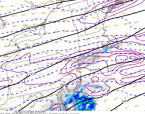
-
OBS-Nowcast for snow 4P Tue 2/11-7A THURSDAY 2/13/25 Mainly NJ-NYC-LI.
jm1220 replied to wdrag's topic in New York City Metro
It's the 700mb fronto band that very often develops in these storms. Someone up there might end up with a few inches. -
OBS-Nowcast for snow 4P Tue 2/11-7A THURSDAY 2/13/25 Mainly NJ-NYC-LI.
jm1220 replied to wdrag's topic in New York City Metro
0.9" now, snowing at decent clip. For those bellyaching about the Nam, the best banding looks north of me if anything. -
OBS-Nowcast for snow 4P Tue 2/11-7A THURSDAY 2/13/25 Mainly NJ-NYC-LI.
jm1220 replied to wdrag's topic in New York City Metro
And if there's snow falling in the LHV it will be wrong since it had zero there. -
OBS-Nowcast for snow 4P Tue 2/11-7A THURSDAY 2/13/25 Mainly NJ-NYC-LI.
jm1220 replied to wdrag's topic in New York City Metro
If you look at the radar over E PA there is snow starting up over the Poconos down to I-78. It won't be heavy but it's headed ENE and should clip most of the LHV. -
OBS-Nowcast for snow 4P Tue 2/11-7A THURSDAY 2/13/25 Mainly NJ-NYC-LI.
jm1220 replied to wdrag's topic in New York City Metro
Snow firing up in E PA. We'll have to watch to see if it congeals into a heavier snow band or stays light, and how far N it expands. Most models at least have some getting into the lower Hudson Valley. If we have snow in NYC/I-80/LI until 8 or 9z, or until 3am we can still have a couple or few inches. -
OBS-Nowcast for snow 4P Tue 2/11-7A THURSDAY 2/13/25 Mainly NJ-NYC-LI.
jm1220 replied to wdrag's topic in New York City Metro
Yep, nice big flakes. Almost 0.5" here. -
OBS-Nowcast for snow 4P Tue 2/11-7A THURSDAY 2/13/25 Mainly NJ-NYC-LI.
jm1220 replied to wdrag's topic in New York City Metro
Good coating here, light snow. -
Can we keep it on topic? There’s a banter thread for other things. Hoping for a positive bust, outside chance at 3-4” if that northern fronto band develops with Atlantic inflow.

