jm1220
-
Posts
24,234 -
Joined
-
Last visited
Content Type
Profiles
Blogs
Forums
American Weather
Media Demo
Store
Gallery
Everything posted by jm1220
-
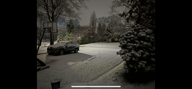
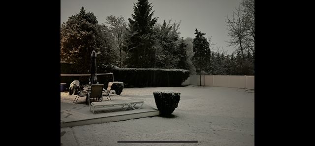
Last of the snow is melting in my backyard today. Was a nice little surprise event.
-
This time of year I’d say it’s something you do once or twice, or you want to go all out like getting a hotel room near Times Square for New Years Eve. I used to work near Grand Central and seeing it the first couple times was nice but after was just a PITA. It was pathetic seeing the Christmas/New Years setup in Austin when I lived there in comparison-really no one does it up like Midtown this time of year so it’s worth seeing it the once or twice.
-
BOS’s run of luck went dry. In the last 5 winters back to 20-21, my backyard 30 miles E of Central Park probably has the same snow on average as them. As much as NYC can’t get away with consistent 40” winters, BOS can’t get away with the 60-70” seasons they were getting and will revert back to their 40” or so long term mean.
-
The 2003 one was fun, as the Part 1 overrunning was supposed to change to rain and never did even on the south shore barrier islands. I had 8" or so from that when there was supposed to be 1-3" maybe before rain. The second part was OK where I live but where the banding could pivot around was epic and ended with 20"+. I think I ended with 13-14". 2002 was also, but it was more a general quick hitting 6-8".
-
That area is generally favored in a Nina for more snow so that’s a good sign for them. Here hopefully any cold we get is less modified.
-
Models seemed to have a better area of precip where I am/better lift which may have overcome the lousy wind direction and brought cold enough air down. Also urban heating tacks a few degrees on. I think the first few miles from any shore had little accumulation.
-
Burst of light snow just ended. Snow on pavement mostly melted but some slush left. There was a half inch or so when I took the pics overnight. I’ll go with what @NorthShoreWx says for final total lol but glad to see we’re on the board and it was unexpected since this is a storm on a southerly flow. I guess the land component was enough not to completely torch it?
-
Wow, maybe a half inch or so on the table and colder surfaces, snowing nicely. Everything covered. Down to 32.
-
Light snow, 35.
-
I don’t think we’re in a permanent downturn or anything yet, since we can still make it happen with the right setup like in 20-21 or even the storm in Feb in the brief cold enough air window. The pattern in general’s just been atrocious, and we see cold air records still happening in the West. It’s just their turn to bonanza I think. NNE is still cold enough in general that it just snows there with more moisture. Here it’s never been like that and we need help from a good storm track/pattern.
-
We were due for a regression. No way our area can get away with regular 40-50”+ winters and we were due for another crap 80s or late 90s stretch. But we’ll see how long this Pacific SST regime lasts, some of it is probably cyclical and some is climate.
-
Perma-Nina. It’s so prevalent that it was noticeable even in the strong Nino last year. It just added a lot more moisture to the perma-Nina so the East had a near or record wet winter but zero cold other than short couple day periods where it was cold enough for snow IMBY.
-
I’m honestly surprised the constant convection there doesn’t cool it down.
-
Exactly. Bluewave might not be posting what a lot of us want to read but he’s also been accurate. I’ll take accurate and don’t want to see it vs JB-esque weenie garbage that never verifies.
-
I don’t like what the data and verifications are either for my backyard but it is what it is. The weather doesn’t care. I learn a lot from reading these analyses backed by said data I don’t like. Hopefully one of these days soon the W PAC cools down so our outcomes can change.
-
20 here.
-
10-11 had record NAO blocking in a perfect spot for us. No indication that will be happening this time. Again I’m not a total doomer saying it’ll never snow again, but this winter looks like it’ll have the same flavor as the last two where the Pacific jet dominates, with relatively brief periods like this where it’s cooler and we need to make something happen. In Walt’s snow thread I predicted about 50% normal snow which is better than the last 2. I’ll be thrilled if somehow I’m wrong and it does produce.
-
Until the water cools down significantly in the W PAC it’s hard to see how we get a sustained cold period where we can generate storms with good tracks for snow. It supercharges the Pacific jet and promotes the SE ridge. It’s good for the same people it’s always been good for from the NW to NNE. Hopefully which doesn’t mean much-it’ll be better than the last 2 winters but we’ll have to bank on making the most of the favorable windows we do get which looks like this one will get wasted.
-
Good. If it won’t snow, useless cold (which isn’t even that cold) is just that.
-
Any event with south winds near the coast this time of year is a no-go for snow prospects. Inland where the wind isn’t directly off the water might have a chance. Steep lapse rates like Bluewave showed are conducive for strong wind gusts so maybe we can get some decent squalls with that.
-
Driving from Melville to Long Beach that evening was an absolute nightmare. Was a car graveyard on the Seaford/Oyster Bay. I was happy to see it was very snowy also in Long Beach but the 2.5 hour drive home sucked. I thought after that storm we’d have another good winter like 17-18 but of course didn’t happen. It was a little better since I moved to where I live now a month after. The March storms were OK where I am now and all rain or white rain on the barrier islands.
-
All of those winters were also snowier than average in NYC. I’m quite confident if we can get the cold in here for more than glancing few day shots, we can get the snow to follow. We haven’t gotten out of these longer lasting cold patterns without at least one decent snow event in the last 20 years, and whatever we get in December is a big bonus for winter as a whole especially in a Nina. In every snowy Nina in NYC we had at least one half decent December snow event. If we get a decent offshore storm track it can definitely be snow in NYC even in early December with cold enough source air.
-
Quite windy the last couple hours. Lawn furniture blown all over the place.
-
I would forget about this one for any snow around the city and coast, maybe well inland with some elevation can benefit. The Goldilocks zone between too far N which brings warm air in or too far S/weak which means suppressed or no dynamics in a marginal airmass is too narrow.