

It's Always Sunny
-
Posts
1,945 -
Joined
-
Last visited
Content Type
Profiles
Blogs
Forums
American Weather
Media Demo
Store
Gallery
Everything posted by It's Always Sunny
-

January 10-11 Severe Weather Threat
It's Always Sunny replied to DanLarsen34's topic in Central/Western States
Cap over DFW is due to break soon. 12Z HRRR (last one I checked) was too early breaking the cap but 18Z NAM has it broken by 21Z. Those height falls around 850-700mb approaching from the west should break it open. -
January 10-11 Severe Weather Threat
It's Always Sunny replied to DanLarsen34's topic in Central/Western States
I'm surprised they didn't extend the moderate west that cap is modeled to be gone by 18Z. Once they start firing up around 18-19Z it won't be long until those are warned.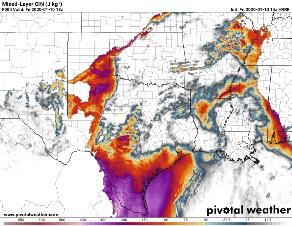
-
January 10-11 Severe Weather Threat
It's Always Sunny replied to DanLarsen34's topic in Central/Western States
I think it's possible the mdt extends west into Dallas. -
January 10-11 Severe Weather Threat
It's Always Sunny replied to DanLarsen34's topic in Central/Western States
Updated SPC image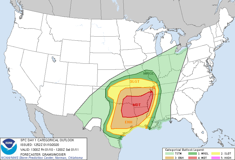
-
January 10-11 Severe Weather Threat
It's Always Sunny replied to DanLarsen34's topic in Central/Western States
Dallas officially in the enhanced. Here we go... -
That was just before I moved here I knew it was sometime around then, and it was snow/sleet, not freezing rain. Those two pictures in that link are hilarious. Typical TX weather lol.
-
The low level cold will be locked in but it is whether we have the moisture to allow for some frozen precipitation to materialize. Like cheese said it's been some time since we've had something like this here. We're due lol. Last notable winter precipitation event in DFW area was February 2015 I believe with the FZRA.
-
I agree it's one of those events where dynamics will win out, increase those ratios and give that area more than advertised. We'll see will surely be fun to watch tomorrow.
-
14.5" in Lowell. That was a great winter for me
-
That was a La Nina year too when sirens went off for a productive winter.
-
Anything under 24" is called "futile" by some snow weenies lol. I would assume there were some winters that received nearly nothing. I wonder if they used the term, "global warming" back then.
-
Other than a couple mini events in January Boston had nada. Blue Hill did good with that October nor'easter...got 6" of paste. I remember having to walk a mile up to the observatory that morning due to downed trees lol. Blue Hill actually set a monthly snowfall record of 8.5" for that October.
-
January 10-11 Severe Weather Threat
It's Always Sunny replied to DanLarsen34's topic in Central/Western States
Yikes! -
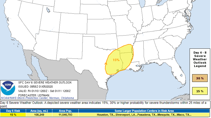
Bit of a west tick puts Dallas in the 15% risk now:
-
Analogs suggest a lower MS Valley outbreak as of right now.
-
Models trended slightly east overnight which doesn't surprise me. DFW was on the western fringe to begin with but still plenty of time for models to change:
-
Given the pattern this month could see a couple slight risk days here in N TX and parts of the SE as well.
-
For the most part. Like I mentioned earlier I think some of that dry air could integrate some FZRA/FZDZ to areas north of ORH as we head into tonight and overnight.
-
Dry air in water vapor starting to punch through mid-levels in parts of CT, MA, VT & NH could see some stations flip from SNPL to FZRA or even FZDZ.
-
January 5th and 6th have slight potential if that s/w over TX doesn't dig so far south because it currently doesn't phase with that other s/w coming out of Alberta until it's on the east coast which is too late. I think it's still possible phasing happens sooner, and further north to allow for a potential winter event for New England.
-
Probably for the panhandle everywhere else will be rain.
-
Climate change.
-
What are you expecting at PWM? Based on what I was looking at tonight, well, this morning now I guess lol, I was thinking 4-6" mainly this afternoon.
-
NAM appeared to be verifying the best in regards to the location of the warm nose when I got into work but I haven't checked to see what it was showing yesterday.
-
What were ya'll expecting I haven't looked at models for New England until I got into work this evening. I thought SNE was generally looking at a 1-3" scenario with a mixed bag of precipitation. Everyone seems pretty let down.


