Indystorm
-
Posts
5,310 -
Joined
-
Last visited
Content Type
Profiles
Blogs
Forums
American Weather
Media Demo
Store
Gallery
Everything posted by Indystorm
-
Chicago area point forecasts show 50% chance of t storms after 10 p.m. tonight. Would this be from storms moving in from the nw or from the boundary to our south moving back ne as a quasi WF?
-
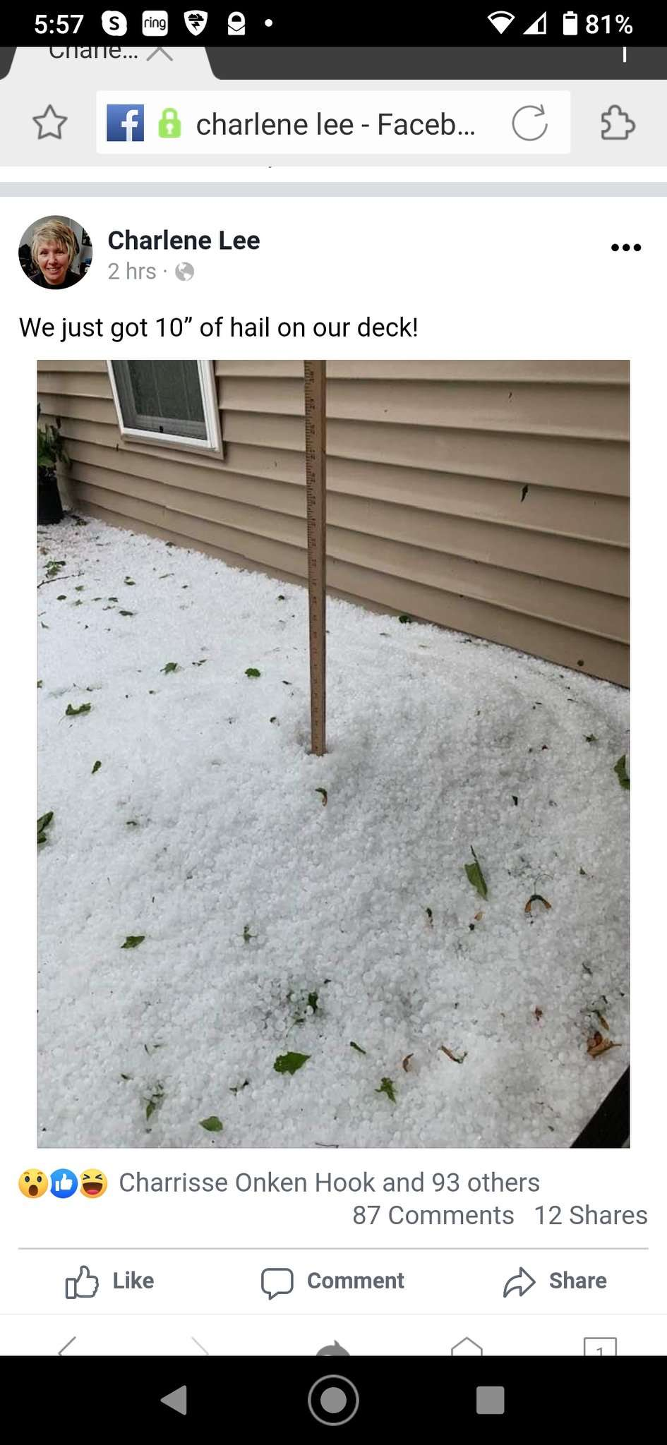
That ten inch hail report depth is from Brookston IN just north of Lafayette from a storm this afternoon. May be measured in some drifting, but crops and leaves were devastated in the area.
-
-
Yeah, that outflow boundary from noonday storms around Chicago metro might be strong enough to keep the nw/se axis of svr storms this Sat. eve a bit sw of Chicago area proper. Will have to see what happens. But mid week does look like a ring of fire scenario around here as has been stated.
-
Storms might lay down some good boundaries for later this evening in Chi town area. We'll have plenty of time to recover. These mid day storms moved a bit farther east than I initially expected.
-
-
Thanks for the well wishes Hoosier and IWXwx. Since I grew up in Hobart it's like it's around the world and back again. Now if we can just get past coronovirus with a vaccine or effective treatment I will be most happy and thankful. In the meantime I intend to get out hiking locally and watching the weather.
-
Yep, it looks like this heat dome is going to stick around for awhile this month with only minor fluctuations. I have moved from central IN up to Griffith to keep an eye on our moderator Hoosier. lol Actually I have moved up here to be closer to family in my retirement five minutes away in Highland. But I will miss sending in reports to all of you from the ne side of Indpls metro as I have been doing for the past six years.
-
Helicity is 300 to 400 m2/s2 in the area of DeKalb approaching higher levels near the lakeshore. LL lapse rates are very good just to the south of the area.
-
0-1 km helicity up to 500 around Chi town. No wonder these mini cells are spinning.
-
BULLETIN - EAS ACTIVATION REQUESTED TORNADO WARNING NATIONAL WEATHER SERVICE CHICAGO/ROMEOVILLE 747 PM CDT TUE JUN 9 2020 THE NATIONAL WEATHER SERVICE IN CHICAGO HAS ISSUED A * TORNADO WARNING FOR... SOUTHEASTERN COOK COUNTY IN NORTHEASTERN ILLINOIS... NORTHWESTERN LAKE COUNTY IN NORTHWESTERN INDIANA... * UNTIL 830 PM CDT. * AT 747 PM CDT, A SEVERE THUNDERSTORM CAPABLE OF PRODUCING A TORNADO WAS LOCATED OVER HOMEWOOD, OR OVER GLENWOOD, MOVING NORTHEAST AT 35 MPH. HAZARD...TORNADO. SOURCE...RADAR INDICATED ROTATION. IMPACT...FLYING DEBRIS WILL BE DANGEROUS TO THOSE CAUGHT WITHOUT SHELTER. MOBILE HOMES WILL BE DAMAGED OR DESTROYED. DAMAGE TO ROOFS, WINDOWS, AND VEHICLES WILL OCCUR. TREE DAMAGE IS LIKELY. * THIS DANGEROUS STORM WILL BE NEAR... MUNSTER AND DOLTON AROUND 755 PM CDT. CALUMET CITY AND BURNHAM AROUND 800 PM CDT. HAMMOND AND WHITING AROUND 805 PM CDT. EAST CHICAGO AROUND 810 PM CDT.
-
TORNADO WARNING NATIONAL WEATHER SERVICE CHICAGO/ROMEOVILLE 713 PM CDT TUE JUN 9 2020 THE NATIONAL WEATHER SERVICE IN CHICAGO HAS ISSUED A * TORNADO WARNING FOR... SOUTHEASTERN WILL COUNTY IN NORTHEASTERN ILLINOIS... CENTRAL LAKE COUNTY IN NORTHWESTERN INDIANA... * UNTIL 800 PM CDT. * AT 712 PM CDT, A SEVERE THUNDERSTORM CAPABLE OF PRODUCING A TORNADO WAS LOCATED OVER GRANT PARK, OR NEAR MOMENCE, MOVING NORTHEAST AT 40 MPH. TRAINED SPOTTERS HAVE REPORTED A FUNNEL CLOUD WITH THIS STORM. HAZARD...TORNADO. SOURCE...RADAR INDICATED ROTATION. IMPACT...FLYING DEBRIS WILL BE DANGEROUS TO THOSE CAUGHT WITHOUT SHELTER. MOBILE HOMES WILL BE DAMAGED OR DESTROYED. DAMAGE TO ROOFS, WINDOWS, AND VEHICLES WILL OCCUR. TREE DAMAGE IS LIKELY. * THIS DANGEROUS STORM WILL BE NEAR... BEECHER AROUND 725 PM CDT. CEDAR LAKE AND LAKE DALECARLIA AROUND 735 PM CDT. ST. JOHN AND DYER AROUND 740 PM CDT. SCHERERVILLE, CROWN POINT AND HIGHLAND AROUND 745 PM CDT. MERRILLVILLE, GRIFFITH AND WINFIELD AROUND 750 PM CDT. GARY AND HOBART AROUND 800 PM CDT. THIS INCLUDES... ILLIANA MOTOR SPEEDWAY AND LAKE COUNTY FAIRGROUNDS.
-
And my cousin in Highland IN just called to tell me she had a number of shingles blown off her roof from a band that went through there just a short time ago.
-
Good call Purduewx
-
I know SPC is pessimistic with that meso wrt a possible tornado watch for se IL into sw and central IN but whenever I see altocumulus cloud streets with other svr parameters being favorable I have to wonder. Only problem seems to be lack of a sustained trigger or focus at the moment.
-
Nice tropical band of pouring rain here now with wind gusts in the low 30 mph range.
-
From IND early morning discussion CAMs have been consistently picking up on the development of a band of convection moving from southwest to northeast this afternoon. Potential for severe weather to accompany this band of storms is certainly there as shear and storm relative helicities will both be rising and an 850mb jet will be approaching. Instability however appears to be lacking a bit through 20Z which may serve to mitigate the intensity of the convection somewhat. In addition...low level directional shear is minimized to some degree. At this point...gusty winds and torrential rainfall may be the primary threats from this band as PWATs surge above 2 inches. Once this band of convection passes however...the airmass will quickly become much more favorable for severe weather and rotating updrafts with a focus over the western part of the forecast area as stronger shear... helicities and instability advect into the region. Model soundings become increasingly impressive as low level winds back and flow increases at 850mb with the arrival of a jet max at 60- 70kts along the Indiana-Illinois border. Helicities will rise to near 300 m2/s2 in the 0-1km layer with long looping hodographs in the lowest 1-2km for a few hours. Finally...LCLs will drop once the band passes late this afternoon potentially to as low as a few hundred meters. All of these parameters support a heightened threat for a few tornadoes with any convection that can get going focused on roughly the 21Z to 02Z timeframe this evening. Damaging winds will be possible as well with lapse rates briefly steepening through the boundary layer and having an easier time tapping into the stronger winds at 850mb.
-
79/68 at Indpls at 10 a.m. EDT. That dew point has really increased from the mid 50's yesterday. The dry slot referenced in the SPC discussion is concerning. Bright sunshine here now.
-
Probably CAPE....convective available potential energy.....high values in Ohio usually seen in OK and TX. I had an EF-2 that day touch down eight miles ne of me in Pendleton IN.
-
Hoosier special BULLETIN - IMMEDIATE BROADCAST REQUESTED SEVERE THUNDERSTORM WARNING NATIONAL WEATHER SERVICE CHICAGO/ROMEOVILLE 423 PM CDT SAT MAY 23 2020 THE NATIONAL WEATHER SERVICE IN CHICAGO HAS ISSUED A * SEVERE THUNDERSTORM WARNING FOR... NORTHWESTERN PORTER COUNTY IN NORTHWESTERN INDIANA... NORTHERN LAKE COUNTY IN NORTHWESTERN INDIANA... * UNTIL 530 PM CDT. * AT 423 PM CDT, A SEVERE THUNDERSTORM WAS LOCATED OVER LANSING, MOVING EAST AT 25 MPH. HAZARD...GOLF BALL SIZE HAIL AND 70 MPH WIND GUSTS. SOURCE...RADAR INDICATED. IMPACT...PEOPLE AND ANIMALS OUTDOORS WILL BE INJURED. EXPECT HAIL DAMAGE TO ROOFS, SIDING, WINDOWS, AND VEHICLES. EXPECT CONSIDERABLE TREE DAMAGE. WIND DAMAGE IS ALSO LIKELY TO MOBILE HOMES, ROOFS, AND OUTBUILDINGS. * THIS SEVERE THUNDERSTORM WILL BE NEAR, HAMMOND AND SCHERERVILLE AROUND 430 PM CDT. EAST CHICAGO AND HIGHLAND AROUND 435 PM CDT. GRIFFITH AROUND 440 PM CDT. MERRILLVILLE AROUND 445 PM CDT. GARY, LAKE STATION AND NEW CHICAGO AROUND 455 PM CDT. HOBART AND OGDEN DUNES AROUND 505 PM CDT. PORTAGE AND WHEELER AROUND 510 PM CDT. CHESTERTON, BURNS HARBOR AND SOUTH HAVEN AROUND 515 PM CDT.
-
I usually think of vertically stacked upper level lows as not being an especially proficient svr wx maker, but this one has been going to town the past couple of days.
-
BULLETIN - EAS ACTIVATION REQUESTED TORNADO WARNING NATIONAL WEATHER SERVICE QUAD CITIES IA/IL 419 PM CDT SAT MAY 23 2020 THE NATIONAL WEATHER SERVICE IN THE QUAD CITIES HAS ISSUED A * TORNADO WARNING FOR... NORTHEASTERN JO DAVIESS COUNTY IN NORTHWESTERN ILLINOIS... * UNTIL 430 PM CDT. * AT 419 PM CDT, A CONFIRMED TORNADO WAS LOCATED OVER WARREN, OR 14 MILES SOUTHEAST OF DARLINGTON, MOVING NORTH AT 20 MPH. HAZARD...DAMAGING TORNADO. SOURCE...PUBLIC CONFIRMED TORNADO. IMPACT...FLYING DEBRIS WILL BE DANGEROUS TO THOSE CAUGHT WITHOUT SHELTER. MOBILE HOMES WILL BE DAMAGED OR DESTROYED. DAMAGE TO ROOFS, WINDOWS, AND VEHICLES WILL OCCUR. TREE DAMAGE IS LIKELY. * THIS TORNADIC THUNDERSTORM WILL REMAIN OVER MAINLY RURAL AREAS OF NORTHEASTERN JO DAVIESS COUNTY, INCLUDING THE FOLLOWING LOCATIONS... JO DAVIESS COUNTY FAIRGROUNDS AND APPLE RIVER CANYON STATE PARK.
-
Just saw the cancellation Hoosier. You lucked out, but now new svr warning for ping pong hail just west of you.
-
Nor have I. Just the new svr warning for Wilmington.
-
String of pearl mini supercells along I-57 north of Champaign/Urbana to Chi town right now on radar.