

NeffsvilleWx
-
Posts
6,871 -
Joined
-
Last visited
Content Type
Profiles
Blogs
Forums
American Weather
Media Demo
Store
Gallery
Posts posted by NeffsvilleWx
-
-
3 minutes ago, Superstorm said:
Centerville, Road and Route 30, “Linkaster”, PA:
27F, Light snow
.WTF.... Imperial Drive and Marietta Ave.
Get outta my backyard!
-
13 minutes ago, MAG5035 said:
Wow, this might have been the snowiest GFS run of them all right at game time. Both that and the 3k NAM have 3' at IPT (via Kuchera). Huge difference in the York/LNS realm though. That's going to be something to watch today which model wins with the thermals. Heck the 3k NAM got sleet all the way to KAOO on a huge surge of >0ºC 850mb temps, that's probably not going to happen. York and Lancaster probably aren't quite going to get to 20+ either as there should be some mixing. Given already solid establishment of cold air at 925mb and below via the Canadian high, I still feel most mixing is going to be in the form of sleet north of the mason-dixon.
@Eskimo Joe mentioned that temps in Baltimore County are lower than forecast, so that's gotta be a good sign for those of us closer to the Mason/Dixon since Baltimore is generally "upstream" of the expected warm air.
Wonder if that temp delta is true for Port Deposit and Wilmington, too.
-
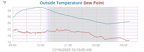
-SN, 28º (MADIS QC'D)
-
flurries 6.6 miles WSW of LNS
-
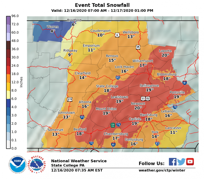
Why you posting yesterday's map? Clear your cache.
Here's the latest:
-
6 minutes ago, Itstrainingtime said:
Nothing here 6 miles to your south yet...
Nothing on the ground 10 miles ESE of you, either. Radar indicates some virga though.
Watching that Temp/DP and looking for them to start closing. But for the moment, they're stuck about 12º apart.
-
5 minutes ago, CarlislePaWx said:
as well as so many folks participating in our thread
I'm only back because Horst retired

-
 1
1
-
-
26/15 IMBY.
Got that humid cold feel that accompanies snow.
-
1
-
-
18 minutes ago, Itstrainingtime said:
Years ago (as in at least 20-25) a recently retired met from MU made a call for like 0"-24" for Lanco. People thought he was a coward for putting out a range that incredulous...it ended up being almost spot on. Our proximity to the ocean and not having a chain of mountains surrounding us can break hearts all too often. That same proximity to the big pond can pay huge dividends though, too.
late 90's, I believe. Went to bed sure school would be closed. Woke up to brown grass. Still haven't gotten over my distrust of snow forecasts.
-
5 minutes ago, JTrout said:
Lancaster show 2 inches to the south and almost 30 at the NW tip. Some gradient on the nam 3k....geez. 30 mile shift and it’s boom or bust for my county if this verified.
Isn't that true (in some form: n/s, e/w) for almost all major Lancaster area snowfalls?
Mixing and dryslots (or fear of), and large gradients are pretty much the norm.
-
1
-
-
1 minute ago, sauss06 said:
Nope. Unfortunately i drink Miller lite now
No wonder we're looking at a mauling in december....
-
 1
1
-
-
@sauss06, stocked up on PBR yet?
-
1
-
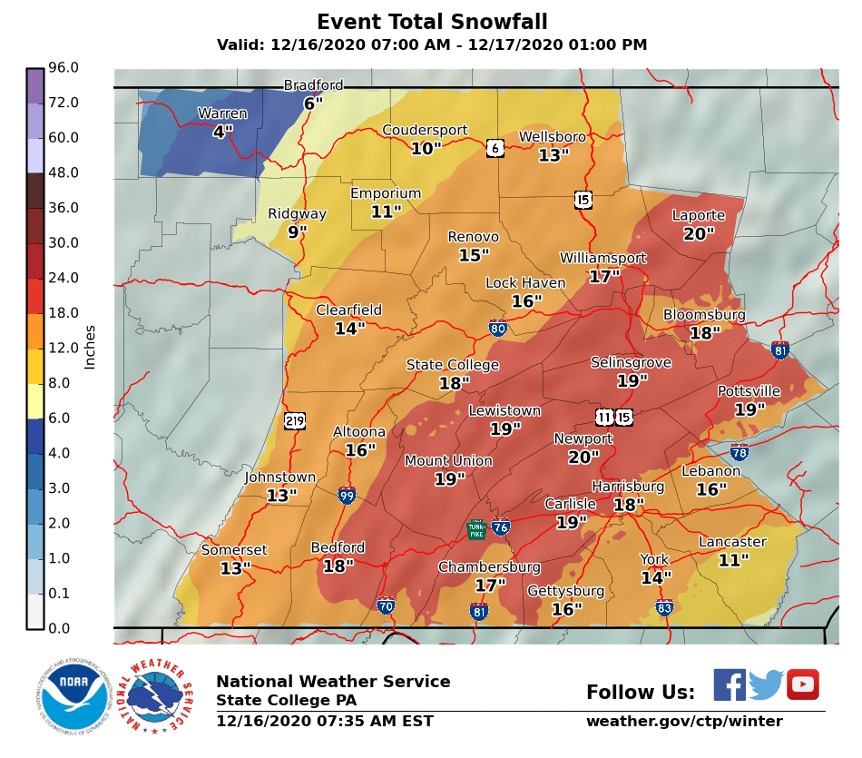
December 16 2020 CTP Snowstorm Disco and Obs
in Upstate New York/Pennsylvania
Posted
I wouldn't expect the mixing threat to materialize until the offshore low really picks up steam, so not sure that's a valid reference point (unless it differs significantly from model guidance)