

AfewUniversesBelowNormal
-
Posts
4,753 -
Joined
-
Last visited
Content Type
Profiles
Blogs
Forums
American Weather
Media Demo
Store
Gallery
Everything posted by AfewUniversesBelowNormal
-
Not really possible. Can I have a job?
-
The way it's moving now, there is pretty much no way the La Nina holds. Peak season is not passed so there is still some time for a cold push, but subsurface and surface are all moving toward Neutral. Record warm Northern Hemisphere SSTs are the real thing, and I wonder if this will drive weak El Nino in the Spring. It seemed to work last year. Imagine these record SSTs and a developing real El Nino... The jump in certain statistics would be so large I wonder if it's even possible.
-
 How are you doing? Is the blizzard kind of a warm wet snow?
 -
lol the roads are wet.
-
Southeast Sanitarium - A Place to Vent
AfewUniversesBelowNormal replied to Jonathan's topic in Southeastern States
gravity waves... I bet closer to center of storm it is much different. like the antarctic or something. -
Southeast Sanitarium - A Place to Vent
AfewUniversesBelowNormal replied to Jonathan's topic in Southeastern States
Here goes..... I was trying to make money in 2010 to move on, but weird energy stuff started happening and I got real big. This was unexpected eventually by 2013 I met my obstacle to the money piece. So I had to go back home rebuild.... it was surprising the stocks would move against me more than my ability to make money, especially because there was no reason... I began predicting weather in spare time to make use of awesome pattern recognition ability and enhancing, and I think the wrong people got a hold of my December forecast because it has not been warm because of strange cold pattern. Now this storm is dry and there is a line going through Kansas to Canada... -
Southeast Sanitarium - A Place to Vent
AfewUniversesBelowNormal replied to Jonathan's topic in Southeastern States
I'd be interested in how Florida does snowwise. -
Southeast Sanitarium - A Place to Vent
AfewUniversesBelowNormal replied to Jonathan's topic in Southeastern States
Yeah, precip will likely fill in much more. -
Southeast Sanitarium - A Place to Vent
AfewUniversesBelowNormal replied to Jonathan's topic in Southeastern States
NAM is a weird model... GFS too dry for this storm. Something much different probably. -
Southeast Sanitarium - A Place to Vent
AfewUniversesBelowNormal replied to Jonathan's topic in Southeastern States
Does it feel like before a storm? The air is dry or sun hot or something. -
Southeast Sanitarium - A Place to Vent
AfewUniversesBelowNormal replied to Jonathan's topic in Southeastern States
yeah there's real stuff going on lol -
Southeast Sanitarium - A Place to Vent
AfewUniversesBelowNormal replied to Jonathan's topic in Southeastern States
This cold will be hard to do again. -
Southeast Sanitarium - A Place to Vent
AfewUniversesBelowNormal replied to Jonathan's topic in Southeastern States
It's kind of it's signature though, GFS does well with S-N storms. -
Southeast Sanitarium - A Place to Vent
AfewUniversesBelowNormal replied to Jonathan's topic in Southeastern States
DT in 20 years... -
Southeast Sanitarium - A Place to Vent
AfewUniversesBelowNormal replied to Jonathan's topic in Southeastern States
The devil lives in Texas. -
Southeast Sanitarium - A Place to Vent
AfewUniversesBelowNormal replied to Jonathan's topic in Southeastern States
I would think the highest snowfall potential of the whole North America is here. Georgia-SC-NC (I guess Florida, that would be cool.) -
Arctic Sea Ice Extent, Area, and Volume
AfewUniversesBelowNormal replied to ORH_wxman's topic in Climate Change
Probably not a coincidence that there has been so much -EPO since 2013. The NAO has been positive something like 5 years in a row, but if you map 500mb heights, there is a spike positive anomaly over Greenland. -
Southeast Sanitarium - A Place to Vent
AfewUniversesBelowNormal replied to Jonathan's topic in Southeastern States
Check it out on the west coast, another reflection of upper atmosphere. -
Southeast Sanitarium - A Place to Vent
AfewUniversesBelowNormal replied to Jonathan's topic in Southeastern States
You would have weak cold waves rotating around 500mb high, and will little force anywhere the natural tendency is for gulf moisture to be avaliable. -
Southeast Sanitarium - A Place to Vent
AfewUniversesBelowNormal replied to Jonathan's topic in Southeastern States
This is going on at 10mb and -SOI -
Southeast Sanitarium - A Place to Vent
AfewUniversesBelowNormal replied to Jonathan's topic in Southeastern States
Because why is a massive High pressure building in? Because there is a warm bubble in Canada at 10mb? The pattern has no support from blocking regions, NAO etc. It shouldn't reload 3-4 times. -
Southeast Sanitarium - A Place to Vent
AfewUniversesBelowNormal replied to Jonathan's topic in Southeastern States
Does anyone think it is so strange that the SE ridge isn't popping up in a few days? -
How Important Is The -NAO For Top 10 Snowstorms?
AfewUniversesBelowNormal replied to bluewave's topic in New York City Metro
It would be cool to see a larger sample size, and also time of year. My guess is NAO is very important for NYC, 2:1 to 3:1 for snow. -
Really impressive warm SSTA.
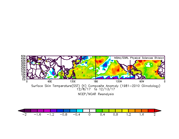
-
Why has State College had like 50% of average snowfall in the last 20 years?


