

AfewUniversesBelowNormal
-
Posts
4,753 -
Joined
-
Last visited
Content Type
Profiles
Blogs
Forums
American Weather
Media Demo
Store
Gallery
Everything posted by AfewUniversesBelowNormal
-

Arctic Sea Ice Extent, Area, and Volume
AfewUniversesBelowNormal replied to ORH_wxman's topic in Climate Change
I'm not sure of this data.. NASA I think shows something different. -
Arctic Sea Ice Extent, Area, and Volume
AfewUniversesBelowNormal replied to ORH_wxman's topic in Climate Change
Global pattern change coming in 6-7 days per models, I think it will accelerate ice melt to near record levels through July (I can already feel it) -
Arctic Sea Ice Extent, Area, and Volume
AfewUniversesBelowNormal replied to ORH_wxman's topic in Climate Change
If you factor in the exponential increase of ice loss in time it's a nonpoint I guess. This is more saying we are leveling up global warmth/overall melt, in a few days. -
Arctic Sea Ice Extent, Area, and Volume
AfewUniversesBelowNormal replied to ORH_wxman's topic in Climate Change
There is near record Hadley Cell expansion coming up in a pattern change in 6-7 days. Would favor arctic melt down the line I think. -
Arctic Sea Ice Extent, Area, and Volume
AfewUniversesBelowNormal replied to ORH_wxman's topic in Climate Change
Surface is much warmer than upper levels right now in the Northern Hemisphere. Low at 500mb could be very warm at the surface in certain places. -
Arctic Sea Ice Extent, Area, and Volume
AfewUniversesBelowNormal replied to ORH_wxman's topic in Climate Change
This would actually be an impressive melt pattern for the arctic if it verifies http://mp1.met.psu.edu/~fxg1/ENSHGTAVGNH_6z/ensloopmref.html Beyond there, there is guidance for +Jul-Aug. Big melt season I think Also, today seems to be a switch from less favorable to favorable. -
It goes something like every event that has broke in June-July peaks in October-November or later. Subsurface looks like a 2 month warming at least.
-
Coldest wind chill by state
AfewUniversesBelowNormal replied to beavis1729's topic in Lakes/Ohio Valley
The upper midwest one's aren't that impressive. -50 in Chicago? Big deal. I bet the further south has some better extremes. I bet the western 1/3 of the country has some better extremes. -
Now the modeled pattern is shifting a little bit. I think more in an AMO thing though.
-
Some things on this forum are rather threatening
-
Who is Cobalt? Do you think that's rain?
-
-
Arctic Sea Ice Extent, Area, and Volume
AfewUniversesBelowNormal replied to ORH_wxman's topic in Climate Change
It looks now like it may go into a stronger Nino
-
Arctic Sea Ice Extent, Area, and Volume
AfewUniversesBelowNormal replied to ORH_wxman's topic in Climate Change
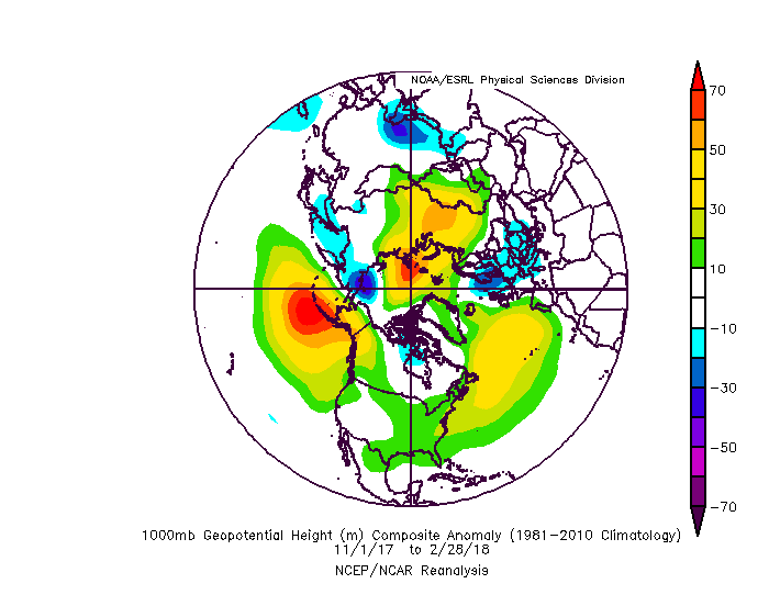
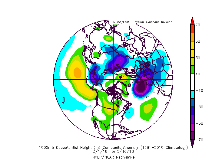
Ok.. look at how this filled in in the north part of Greenland then become an arctic circle block (models were consistently negative anomaly here until a day ago). I think this is the same trend from the Winter and it will be a large arctic ice melt season -
Arctic Sea Ice Extent, Area, and Volume
AfewUniversesBelowNormal replied to ORH_wxman's topic in Climate Change
-
Definitely El Nino, subsurface is leading indicator
-
Subsurface trends early 2018 has 7 analogs.. 3 went El Nino, 4 were Neutral. The way it's going, I would guess Weak or low end Moderate El Nino as a max, about the same % chance for Neutral, and slight chance we go back to Weak Nina in the Fall. Hurricane season is probably active with a lot of US misses.
-
Next year might be El Nino so that would be interesting with how warm N Hemisphere SSTs were this Winter.
-
Southeast Sanitarium - A Place to Vent
AfewUniversesBelowNormal replied to Jonathan's topic in Southeastern States
I would think in a 1000 year period the largest snowfall would happen in the Southeast, US. probably Florida -
Central/Western Medium-Long Range Discussion
AfewUniversesBelowNormal replied to andyhb's topic in Central/Western States
This is some pretty awesome cold for April. Wonder if it verifies. -
98-99, 99-00, 00-01. It's not too uncommon. 54-56 had a nice streak. 73-76 http://origin.cpc.ncep.noaa.gov/products/analysis_monitoring/ensostuff/ONI_v5.php I think a 3rd Nina year would be weird because of Global warming bias right now. 1 center El Nino event since 2010 in this exponentially warming climate?
-
Don't expect it to go El Nino anytime soon.. subsurface for this late in the Winter may even support a Nina rebound in the Summer if it doesn't persist at the surface
-
http://sites.uci.edu/zlabe/arctic-temperatures/
-
Southeast Sanitarium - A Place to Vent
AfewUniversesBelowNormal replied to Jonathan's topic in Southeastern States
You'll love this one, Global warming is another way of saying dimension split.. we are on really really low end here. Almost to the point of not going back but not quite yet but we are heading that way
