ILMRoss
-
Posts
665 -
Joined
-
Last visited
Content Type
Profiles
Blogs
Forums
American Weather
Media Demo
Store
Gallery
Everything posted by ILMRoss
-
Yeah it's just a climatology quirk. I will say though that I'm surprised that the outer regions haven't been bit by an ice storm in a while. The February 2014 storm featured a "super CAD" that gave my parents in Wilmington and others at that latitude a pretty legit ice storm; my neighbor's tree came down. Other 10 mile strips (like the 158 corridor on Saturday) have been nabbed by some 0.25-0.75 events in various transition zones. but there hasn't be a catastrophic 2002 redux that hits the "middle sections" hard in a while, and frankly I'm surprised those types of storms don't come more often since CAD can be so readymade.
-
I've taken a few days off from watching models and living vicariously through my sister, who's a student in Memphis. I asked for a lot of pictures, but the high today is supposed to be 12 (!?!?) , so i kind of doubt she's going to be leaving her apartment very much. Otherwise, I can't endorse nodding off before the 00z GFS thoroughly enough, my sleep has improved drastically. Anyway, I'm pretty concerned with the storm later this week. Another textbook CAD, but this one seems to be much more consistent in modeling. The reason some "superwedges" last weel that went all the way to Alabama didn't pan out is because the high began to trend north- the strength of the high doesn't matter if the pressure in that critical zone between eastern PA and central VA keep on ticking down 1-2 millibars per model run! This cycle though, with a 1035-1037 being consistently modeled over the fingerlakes of NY, gives me more pause. This is when our "known errors" with CAD (cyclogenesis issues, temperature busts etc) can become a more powerful forecasting tool since the model high depiction is more reliable. Also somewhat concerning is the GFS muting the southeast ridge run after run- I think we're pretty close to seeing more pressure falls over the gulf stream help lock in a CAD. This has my attention now!
-
Yeah it’s definitely a buzzkill. But I’m happy that there’s a lot of people in the mid-south that are getting their once-in-a-generation pattern where every impulse leads to snow. They deserve it. How many systems stay dry around the western gulf before blossoming around Georgia? It’s not our pattern, and it happens. We still have about a month of fertile winter to track until we’ll need a Hail Mary for anything to pan out. On the bright side, I’ll be happy to get more sleep not staying up for the 00z suites!
-
pretty terrible cycle so far, my spiel on CADs isn't really relevant when your high is all the way in mid Quebec I'll give it a few more cycles but it will take some shifts to get out of the hole tonight put us in
-
man i am so glad i didnt splurge on that wxbell subscription for this storm
-
30-31 is ok for it if the winds are blustery enough and the rainfall rate is light enough. 28-30 is well enough to get the job done. With 30-31, if the winds aren't whipping and the rain is too heavy, a lot is lost as runoff. Also, with self limiting- that's moreso an issue in in-situ cads. While I don't think there will be there encroaching, backdoor front of zr sweeping through the region, I think CAA will be strong enough to maintain here for these NC/VA border regions. Anyone remember the ice storm back in March 2013? I think that was an event that had marginal temps but still packed a hell of an ice storm.
-
Hey all, couple of things to keep in mind for CADs as we go through another model cycle: 1. I generally don't like writing CADs and associated systems off until high resolution models get a crack at them. Seems pretty obvious, but in the equation governing the strength of CADs (which exists!) height of mountains is indeed a variable. topography is going to be better rendered on hi resolution models and mountains will be represented more accurately and not as smoothed out as globals. I trust them a little more! 2. Let's talk low pressure track. If you've been here a few years, it's probably been drilled into your mind that LPs can't just plow into wedges and stable air, and that's true! This is a true thing and generally low pressures will seek areas of lower pressure and ribbons of low level vorticity (almost always where the coastal front and CAD boundary meet). I think it's fair to be dubious of any low pressure track that rides up i95 if there's a 1035+ high anchored in the favored CAD region. Once again, this is something that high resolution models resolve a little better. 3. Now, one thing I want to clear up, is that it's perfectly reasonable, as the GFS showed, for a low pressure to track from Birmingham to Knoxville to Pittsburg. This is because you're on the other side of the Apps- there's no wedge here. In fact, lower pressures exist on the western fringe of the apps during CAD events, and some models are seeing this and tracking the parent low pressures up this lower side. The upper level vorticity, if it's spurring this, is likely too far away to really spark anything over the coast. Here's hoping the 00z cycles show some interesting solutions!
-
sheesh, I can't quite say I'm in agreement... I mean, I'm probably being heretical, I don't want to bet against the collective knowledge of a bunch of mets, but this feels a little reductive and throws too much influence to the Euro, which hasn't exactly been stellar. No model has been particularly stellar here.
-
So far a pretty encouraging model cycle if you want "something / anything" to fall in our neck of the woods (shout out todd rundgren) There's been a lot of posts about the general synoptics of CADs, and I'll try to outline some stuff later today/get into the weeds a little with a longer post later today about how they work and what we need to keep in mind for future cycles.
-
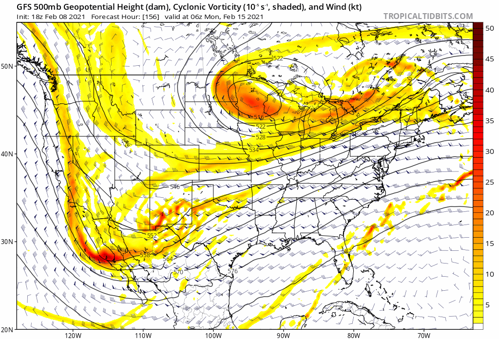
The terrible trend in our models today is the lobe of polar vortex getting stretched and elongated instead of pressing southward some and pressing the cold with it. Last 4 GFS runs: Over the course of 5 runs, the core of the lobe has shifted from Duluth to north of Maine. Now, I don't think the eastward movement is terrible; our high is going to follow this feature and for our purposes I'm not sure that lateral high placement matters a ton when it's already so large and CAD is likely. But the last frame (and the euro/ukmet has this look too), with the vortex getting stretched like a piece of overworked bubblegum, is no bueno, because it keeps our high and our cold press to the north. Whether or not this is going to occur or not is beyond me; at this point you're basically guessing and teasing out fluid dynamics and if it "looks right". I don't favor any solution, it's been a humbling last few weeks and nailing down patterns has proved to be like grabbing a greased watermelon. But I think this is a reasonable solution and we should be prepared if it continues to trend like this.

-
The issue with this, is that while often they are stubborn to be scoured out in environments where wind aloft isn't very strong, it's a different story when winds aloft are screaming in response to a strong cyclone. I think this is a case where I wouldn't lay my hat on it persisting longer. That all being said, that was a mixed Euro run. The good: It was encouraging to see the lead shortwave hold more of it's integrity as it went through the SE, which lead to a stronger, more amped, beefier storm. The CAD signal is robust and at this point I like the consistency of it's depiction. Overall, I think that there's a good chance that the Euro is not rendering the evolution of cyclogenesis correctly and it's likely we have lower pressures off the coast than what it's depicting, which would keep cold air around longer. The bad: The TPV getting strung out is not a great trend. Hopefully future cycles build it back up again, or else a more inland storm track is on the table.
-
Yeah, one thing that gives me extreme pause (like extreme pause) is how many impulses dive under the high from Thursday-Tuesday. While is does seem like most models are beginning to hone in on some "grand finale" type solution early next week, it seems inevitable that one of the prelude impulse will rise up and become slightly more amped/hold its integrity a little more and spread some more precipitation.
-
Before we really get absorbed into this I want everyone to take a really deep breath and think about how many different solutions guidance has thrown out at us in the 160-180hr range over the last week. It has been a kaleidoscope of possibilities. Current setup looks daunting but I’m not too perturbed... yet (I am eating all the seafood in my freezer this week though, just in case)
-
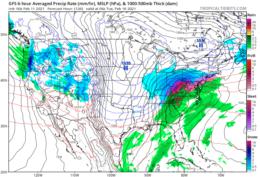
Turns out nobody got rocked lol. Don’t think that shortwave shears as hard as the gfs thinks but we’ll see
-
Good grief... someone is about to get rocked on this gfs run, hope it’s us
-
euro 8 day has a cad high that looks a doodle a college kid in synoptic makes trying to draw up the perfect ice storm. yikes.
-
This is a really good question. I think this is a representation of a few things: GFS/Euro et al represent surface pressures in areas of elevation by taking the parcels at that elevation, and running them through an equation that converts to what the surface pressure would be at sea level. Mexico has a lot of elevation, and ground truth for most stations would likely be sub 950mb readings, which is why this is needed. This process can produce "wonky" isobar patterns (can also see this across the rocky mountains). This can create a "jumpy" representation of low pressures, which is why it looks like lows can shift to weird geographic locations. Another thing is just the orientation of the trough- with a big trough oriented across the MS valley, shortwaves will dive Southeast-ward across that region, which will also naturally produce southward-ish moving low pressures. Lastly, you won't see as many cyclones (low pressures) forming in the gulf as you do the east coast- both the temperature gradient and low level vorticity, items you need to churn out big low pressures, aren't really as strong as they are the east coast, which is why you don't naturally see as many gulf lows form.
-
I think at this point the "do you want an ice-storm" debate is the equivalent of the "does pineapple belong on a pizza" debate, you're going to get some strong reactions either way haha. As for myself, i need to eat all the frozen shrimp in my freezer before i can in good conscience root for a zr storm. GFS showing some all-timer potential for somebody; can't say i'd be bummed if the GFS panned out (although I expect to see many more shifts and solutions)
-
I don’t like the “models have no idea what’s going on” line. I think sometimes that line is used as a crutch and a bit of a copout. That being said... good lord the models are absolutely struggling. I think it’s a mixture of less airplane data + very amplified pattern, where any model errors will matter further in the run more so than usual. I don’t really know how to interpret this and I’m not jealous of mets assigned to figure this out. Instead of “siding” with a model or camp, I think the appropriate thing to do is just to sit back for a few more cycles and see if models key in on anything. While the gfs is an outlier, we seem to be able to summon CAD a little easier than usual this winter and I wouldn’t be shocked to see a CAD-driven mess materialize out of the hazy ether that the 12z guidance left us with.
-
Best Saturday of the year so far in Raleigh
-
At this point I am eying whatever comes after next Thursday/Friday. Which definitely feels painful/foolish after getting the rug pulled under us today, but that cold has to come down at some point.
-
The models will keep on changing. I'm pretty indifferent and still a little numb, the 12z euro was a real groin hit, but there are still arguments to be made for both sides: Pro storm side: models don't have a great grasp on the polar vortex, a feature that's both difficult to model and sample. Ensembles still *totally* show big hits within the realm of possibility. There's still time and room for it to roam back east to be in the position we need. This shift could very well be a "flash", the south-east ridge may be in its apex of modeling, and subsequent runs will begin to bend towards a familiar curve, beating down the ridge a little cycle after cycle. With such an extreme amount of cold air in Canada, any nudges count. Lastly, feels like we've been able to summon CADs out of the ether at will this winter and CAD sneaking in to blast the Carolinas is always a possibility. I mean sheesh, we havent seen 60 in raleigh all winter, is this really what breaks that? Anti storm side: models will continue to slide the polar vortex west and hold it back, bringing troughing out west and puffing up the SER more and more. In a week we start the severe thread to discuss the enhanced risk that spreads from coastal georgia to about morehead city. pick your poison.
-
Doubt many people will like this euro run. sorry folks. we may be playing catchup again for the time being
-
GEFS is way too wind-shield wipery for my taste, will stick with the euro ens, but verbatim it's telling me to buy a portable phone charger and make sure all the heavy blankets are clean
-
I thought the GFS was harmless and i'm not really going to be alarmed until i see wholesale changes on the euro/euro ens.