

ILMRoss
-
Posts
665 -
Joined
-
Last visited
Content Type
Profiles
Blogs
Forums
American Weather
Media Demo
Store
Gallery
Everything posted by ILMRoss
-
I'd like to interrupt the pity party by noting that the 18z GEFS appears colder, stronger with the CAD, further south with our ULL, and with more separation with our northern stream "kicker" compared with the 12z GEFS. Ok, carry on.
-
It's a 51 member ensemble and the gradient through wake county is still 1 to 8 inches I absolutely hate it here
-
It is what it is. I'd rather this be our make or break feature than the SE ridge though, that's for sure.
-
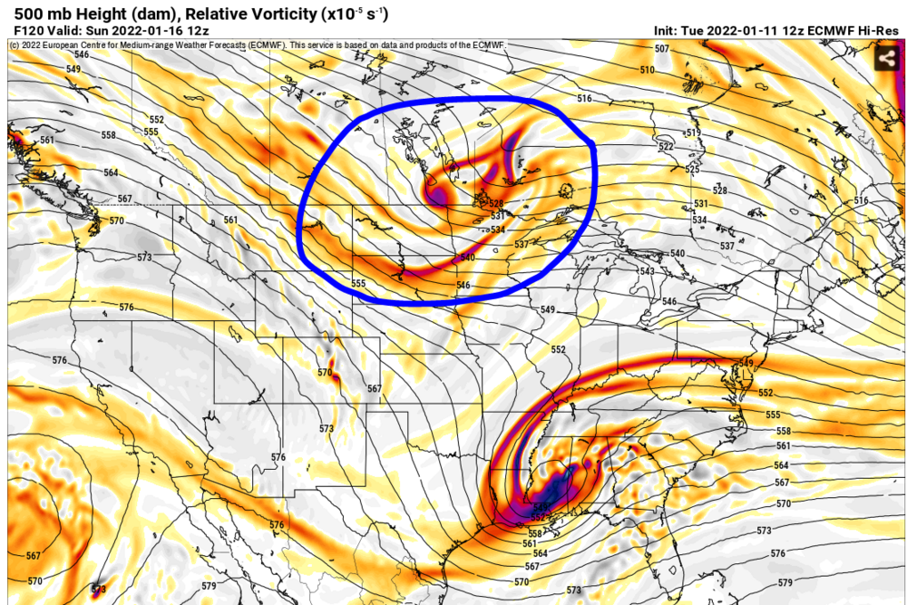
In my opinion, a clear villain emerged from this model suite: This shortwave: This shortwave comes in on just about every global and slingshots our ULL to the northeast, which drives it up the coast. In previous runs, this wasn't an issue because our less amped, quicker system was able to outrun this shortwave. However now that everything's slower, the circled shortwave is exerting some influence. If this shortwave wasn't here, I think the ULL would continue to take a more lateral movement through the SE, putting more southern solutions at play.
-
National Guard needs to be on standby if the Euro is a dud/way too amped. Haven't been this excited/queasy before a Euro run in years.
-
Yeah completely agree on the agreement part. Knock on wood but feels like the big picture synoptic features are settled. More ticks and slides and slips N/S/E/W are coming but it's there. And I don't think we're getting too far over our skis saying that this is typically when the big dogs come into focus.
-
UKMET if i'm looking at the right thing looks way south of CMC/GFS and much better for the eastern parts. (But i may not be looking at things right... stand by)
-
Not too sound too wish-casty but I always feel like there's a couple of "ah! omg! the GFS amps things up and turns things north up to coast!" hysteria runs before it falls back to earth. Not dismissing concerns but I'm not incredibly concerned yet.
-
I don't think this particular rendition of the GFS is handling the LP placement that well. There's a 1035HP high over the NY fingerlakes. Textbook CAD. I would not expect the low to take the inland track as depicted. The 500mb ULL bump N is a separate issue that bears watching but i'm not completely concerned about it yet.
-
I did not know that was the origin. I implore everyone to not get too caught up in the Diet ECMWF.
-
I don't have hard numbers, but I'll tell you this. Every group of pals has someone you're neutral on. She's in the book club. He's in the fantasy football league. They're fine to invite to things. They're a net positive. But at the end of the day, you're not making big decisions based on them. They're not part of the wedding party. They're not in the rehearsal dinner. They're not getting invited to the souped up AirBnB in Blowing Rock. That's how I view the ICON.
-
He's absolutely not wrong synoptically. I'm jabbing him endearingly, the fire is already hot, he knows better than to throw gasoline on it 5 days out (he likes my cat photos on Instagram I'm allowed to say this) You're right. When this was taking a Dakatos-Illinois-NC line it was a clipper but if it takes the GFS's Montana-ArkLaTex-GA line this is will be a bona-fide miller A. Full spectrum still on the table though.
-
I see his point but I personally think it was a mistake to call out the two most ubiquitously heavy snowfalls for the Carolinas in the last 50 years as analogs.
-
Rockingham in the 6 inch contour is a similarly insane model output for an ensemble.
-
This is both the furthest out I’ve ever seen ILM with 4+ inches on the Euro Ens. Come to think of it, this may be the only time I’ve seen ILM with 4+ inches on the Euro Ens. And I always check that, I mean, do you see my username? Lol
-
As fun as that was i’d really rather our model suites stay suppressed for the time being. 00z gfs plays out as forecast and that warm nose is jutting 20-30 miles NW than the model suggests. There’d be some hellacious mixing. Hope the rest of the runs tonight are a little less dramatic
-
Hahahahahaha wow
-
Yeah that storm really rocked. Just a rich period. I stayed in Wilmington for the 1.3.2018 bomb that gave us 4 inches of windswept powder over a half inch of sleety crust. 2 weeks later this even popped up. I was in Wilmington looking for my first weather job while the girl I was dating at the time lived in Raleigh. I asked if I could "visit" once it became apparent 48 hours out something was happening. What I remember about the 1.17.2018 storm is how suddenly it popped up. This was not a "thread 5 days out storm" - 2-3 days out it looked like we'd be really lucky if we got an inch, it just looked so dry! With this storm, the short range models (NAM, RGEM, etc) were the first to really beat the drum that qpf would be actually over 0.5. There was definitely a globals vs. CAMs (convection allowing models) split and if your forecast was all globals and you weren't trusting the CrAzY NaM then you ended up with egg on your face. My weather pals group chat was basically headhunting local news forecasts that were way too conservative (WRAL stuck out) and roasting them for about 36 hours straight. Fantastic storm.
-
Some thoughts: - Really love how the medium-range fog lifted and suddenly every model has general agreement that a nice shortwave will dive down on a general corridor from the Dakotas through the Missouri Valley and eventually getting off the coast... somewhere. That's a win. - I'm pretty ambivalent on the evolution as modeled. On one hand, as Eric Webb noted in his tweets, it's an easier game precip-type-wise to wring moisture via cyclonic vorticity advection (the jargon that is usually described as "dynamics" colloquially) than it is warm advection which brings can cause issues with, as you can guess, the warm nose. On the other hand, this system as currently modeled is pretty moisture starved once it crosses the mountains and gets to us. It would lead to a pleasant story where the entire state gets in on the action, but the downside is that your ceiling is maybe 3-5 inches depending on where the best banding ends up. The way this improves is with a tighter shortwave that's a legit upper level low (GFS version) and/or the currently unmodeled solution where there's some better cyclogenesis and a coastal low is able to beef up qpf for the eastern portion of the state. - Sure does seem like this won't be our only lick in this pattern- I'm not really concerned if this system turns out to be a dud.
-
This idea was a wash. But i do want to highlight that the extent to which this thing Thursday/Friday bombs off the coast is going to have a lot of ramifications on our cold air push, whether this weekend system stays suppressed or rides up the coast, etc, and a lot of the swings we see will probably hinge on that. I think the wise approach the next couple of days is to focus on big picture items (what the shortwave is doing, how strong it is, how far it digs etc.) instead of focusing too much on the surface representation.
-
I love that city and I have a great group of friends there I've been visiting for a while. But I think "more snow but not enough to get sick of it" played a small but not-insignificant portion of the decision. Despite this I'll probably stick around here, I think the MA forum is a little crowded.
-
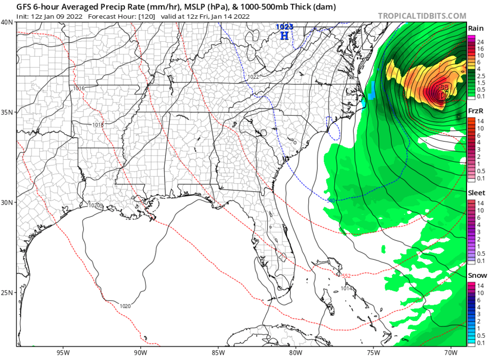
I also wouldn't sleep on whatever this Thursday/Friday coastal is. I'm actually kind of surprised this snuck past everybody. I think that a 968 low 400 miles off of Hatteras is in *insane* look. Snow on the OBX. I think this is worth keeping an eye to see if something truly bombs here (not many other models have something like this).
-
obvious caveats lucy can still pull the football yada yada yada but next few weeks look fun. i am moving to richmond in early february and i'd love to see one more snowstorm here before i move!
-
Want everyone to see this. So Nashville is getting a once in a two-three year snow today (or five year? i don't know nashville). 4 days ago the GFS had a cold, dry overcast day today. Over the course, the GFS evolved from that to the robust snow solution we see today. Just highlighting typical GFS behavior and if you ever wonder why nobody freaks out when the globals lose the storm a couple of days beforehand...this is why. I hac
.thumb.gif.012686af82f7d36d286dd94d0438f95b.gif)
-
I think this is Virginia's storm through and through, and I think that after this brutal December we should be rooting for our neighbors. I think they're in for a nice little paste bomb. After this torch stretch, we should of known a system wouldn't just fall right into our lap, that would of been way too easy!! I'm pretty pessimistic on accumulation. I usually tune the ground temps argument out but I think it has a little more merit after a historic torch. However, I think the northern half of NC gets at the very least some token flakes morning in noon on Monday. I hope it's pretty! Lastly, i wouldn't sleep on the end of the week. A little bit of juiced-up clipper potential. We still likely need some adjustments to have that shortwave dig a little more.


.gif.9c8e82a857f70ff0928373dfe01d1404.gif)