mackerel_sky
-
Posts
16,047 -
Joined
-
Last visited
Content Type
Profiles
Blogs
Forums
American Weather
Media Demo
Store
Gallery
Everything posted by mackerel_sky
-
It’s also showing the farthest South path, that’s what it would take to get those gusts, if they are even possible!? Looks like the “remnant”eyeis S of CAE and heading for Augusta National!
-
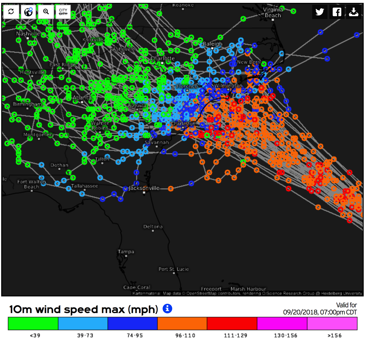
Very tight gradient on precip out here near GSP! Think the Euro gets me 5-7”, GFS gets me like 1”. On Euro, two counties over to my East gets 11” plus! Highest wind gust forecasted is 50-55 on the Euro
-
Pressure has dropped about 3mb, so technically, it’s getting stronger, ir at very least, holding her own
-
Radar looks like it’s definitely moving more W than N now!
-
Looks like the HWRF from yesterday! Doughnut like!
-
GFS gives me about 1” of rain, Euro 7-10” range! Model madness! If I get 3”, I’ll call it a win! One of the models has me getting a 56 mph wind gust! That’ll bring a tree or two down!
-
I don’t understand how I only get 1.5-2” of rain, when the track goes over me or to my South?? GSP
-
CLT , NC, Charlotte, in Mecklenburg county schools
-
CLT schools closed Th/Fri!! Overkill, yes
-
Yeah, the 3 day part must be unusual. But still , pretty scary.
-
High Risk excessive flash flood risk , issued by WPC! It’s only the 2nd time it’s ever issued one of those!! The 1st one was issued for Harvey!!
-
It won’t take the models being off much with forward speed or angle , to push onshore and then stall!
-
Lane reversals begin at noon on I-26 from Charleston to CAE! I expect traffic passing into and through Greenville,SC, to increase quite a bit over the next 2 days!
-
HUGE changes overnight!! The mountain flooding look, is back again!!

-
My favorite game! I think the Myrtle Beach or points N, will be the bullseye. No matter how long it stays on Ddue West movement, won’t matter. The runs today showing NW/SE orientation to the ridge, will still let it come N pretty hard
-
Based on track and speed, Man. Evacs, could start Tues, but def Wed, IMO
-
Cantore is in Wilmington/Carolina beach already!!!
-
Hugo Redux, Hugo Redux, Hugo redux! The amount of possible inland wind damage after this comes on shore, could be worse than Hugo! The flooding will be way worse than Hugo, because every model has it slowing down after it comes ashore. Hugo was 135 mph at landfall, Flo projected to be 140mph. I think the Hugo comparison is warranted, and we might be wishing it was “only” a Hugo, when all is said and done!
-
20-30” that is shown, would be as close to biblical as most will ever see!
-
Starting to cave towards the Euro!?
-
50-100mph wind gusts and 10-30” of rain, as it looks now! Subject to change
-
I don’t think the N or ots trends are over. It’s gonna whiff NC/SC
-
Or Myrtle!
-
Did somebody say mosquito farts!?I’m all in! As for the guy who wants to experience a hurricane, it’s pretty much like JB said, except triple the wind speeds and 7-10 days without power! That’s what it was like going through Hugo in Gastonia! I’ll nevr forget our obnoxious principal coming over the PA system the day before Hugo and announcing that they had never missed a day EVER due to a hurricane! Well about 10 days later, we finally got to hear her sweet voice again!!
-

Southeast Sanitarium - A Place to Vent
mackerel_sky replied to Jonathan's topic in Southeastern States
Is it ok for local weather mets to get busted rain forecasts? It's hilarious they won't say snow until a day out. CJ yesterday said we have a 60-70% chance of rain this weekend coming up, he never goes that high, but models had so much agreement, he had to go that high and Sat/Sun was going to be a complete washout! Lol Actually used " slam dunk" GFS has barely sprinkles on either day now! Guess it's ok to go in on a 6 day rain event! SMDH