-
Posts
5,227 -
Joined
-
Last visited
Content Type
Profiles
Blogs
Forums
American Weather
Media Demo
Store
Gallery
Everything posted by CIK62
-
The last 6 days of April are averaging 59degs.(50/68) or +2.0. Month to date is 53.4[+1.4]. April should end at 54.5[+1.5]. After the April 28/29 T spike, the next spikes look to be May 04/05 and May 09/10-----then a long wait to May 21 for another one? Rain today of about 0.60". 50%(95%RH) here at 6am, light rain. 53* by Noon and brightening skies. 55* at 1pm. Made it to 65* around 6pm, with sunny breaks.
-
The last 7 days of April are averaging 64degs (55/73) or +6.5. Month to date is 53.0[+1.2]. April should end at 55.5[+2.5]. Still about 0.40" to 1.0" rain tomorrow. Model T performance is erratic and useless. At any rate, every model (5 out of 6) has 80+ for Wed. 4/28, except the Euro Ens.---as of the 0Z runs. 50*(47%RH) here at 6am, m. clear. 54* by 9am. 59* by Noon. 62* by 1pm. 65* by 2pm. SE breeze and filtered sun, dropped T to 59* at 3pm. 55* by 6pm, nasty feel.
-
The last 8 days of April are averaging 57degs.(48/66), or just Normal. Month to date is 53.1[+1.4]. April should end near 54.1[+1.1]. GFS now serving up highs in the 50's where it showed the 70's and up to 94 for days. Sunday rain still 0.5" to 1.0". Heavy rain next Sunday too with those lower temperatures. 39*(49%RH) here at 6am, m. clear.(was 43 at midnight). 40* at 7am. 43* by 9am. 50* by Noon. 59* by 3pm. 61*(30%RH) at 4pm. Reached 66*(26%RH) at 6pm.
-
The next 8 days are averaging 57degs.(47/68), or about Normal. Month to date is 53.6[+2.1]. Should be 54.5[+1.5] by the 30th. Some 80's over the next 10 days looks likely. Only 0.5" to 1.0" on Sunday from the GFS/EURO and virtually 0" from the CMC which goes into the 80's therafter. Figure it to cloud up late Sat. and rain to be over by Noon Sun.---then clearing. 36*(59%RH) here at 6am, scattered clouds.(was 40* at midnight) 37* by 9am. 42* by Noon. 46* by 3pm. Reached 48* at 4:30pm.
-
Hey!!! Be the first on your block to have your thermometer read a 90+ this year. Stick it in Central Park. 850mb T soars to 18C. and falls to 3C thereafter. Meanwhile the CMC has lost its 80's from later this month after two days of showing it. Euro still coolest, by T, that is.
-
The next 8 days are averaging 55degs.(45/64), or -1.0. Month to date is 55.0[+2.3]. Should be about 55.0[+2.0] by the 29th. No more than 0.25" rain today showing now? CMC has 3 80's incoming and is the king there for the last two days. Seems a heatwave after the 26th., despite recurving typhoon, becoming more likely. 850mb T is +10C to +12C from 4/29 to 5/05 and this would be AN all the way to early June. 53*(76%RH) here at 6am, mixed clouds,breaks. 54* by 9am. 55* at Noon. T spiked to 59* at 3pm and has crashed to 51* by 5pm with strong winds all day. Heard rumble of thunder at 2:15pm but rain mostly failed here except for a few drops in the morning. 43* at 9pm. 42* at 10pm.
-
The next 8 days are averaging 54degs.(44/64), or -3.0. Month to date is 53.1[+1.9]. Should be 53.4[+0.4] by the 28th. Only EURO does not have the 80's now by the 28th/29th. 51*(77%RH) here at 6am, m. clear. 53* by 9am. 55* by 10am. 62* by Noon. 65* by 1pm. 69* reached at 3pm but quickly back to 63* at 4pm. 67* at 4:30pm., coastal area wackiness. Up To 70* at 5pm!!
-
Models really confused with storm and the T's to follow after the 26th. Rain from storm gone or reduced and T's higher for the 28th/29th. Just Tripe output. Meanwhile I am yet to reach 60* here today. Most of the time just near 56*.
-
The next 8 days are averaging 54degs.(45/64), or -3.0. Month to date is 52.8[+1.8]. Should be 53.2[+0.3] by the 27th. All models have 1" to 2" of rain on the 25th. Even the GEFS makes it into the 70's now about the 28th/29th period. The OP is 5875m and 15C, which puts it +9F over the ensemble mean for this time frame at 2M. 53*(59%RH) here at 6am, m. clear. 57* by 9am. 59* by 2pm. 57* by 4pm. Made it to 61* around 6:30pm.
-
The next 8 days are averaging 53degs.(44/61), or -3.0. Month to date is 52.6[+1.7]. Should be about 52.8[+0.2] by the 26th. CMC has a Trace of snow for the 22nd. GFS out of the 80's and in the 70's for the 29th. 49*(62%RH) here at 6am, thin scattered overcast. 51* by 9am. 53* by 10am. 55* by Noon. 57* at 1pm. 60* at 2pm. Got back down to 53* during PM, 57* at 8pm.
-
YO HO HO and a Bottle of Rum the new GFS is performing like a Bum. There are your 80's. The GEFS still does not show even a 70.
-
The next 8 days are averaging 53degs.(44/62), or -3.0. Month to date is 52.8[+2.1]. Should be about 52.9[+0.4] by the 25th. Quick T transition near 21/22. Another drop near the 26th. Best chance for 80 still near the 29th., another quick change point. Long Range GEFS looks coolish for the first 3 weeks of May! 44*(78%RH) here at 6am, scattered clouds. 47* by 9am. 51* by Noon. 54* at 2pm. 55* by 4pm.
-
The next 8 days are averaging 51degs.(43/59), or -5.0. Month to date is 53.1[+2.7]. Should be 52.3[near Normal] by the 24th. 43*(81%RH), m. clear. 44*(66%RH). 48* at 1pm. 51* at 2pm.
-
Yes, watch the 28th. The Mean and the OP are playing with 10C on the 850mb T, and 200m on the 500mb heights. At any rate looks like a short outburst.
-
The next 8 days are averaging 54degs., (46/62) or about Normal. Month to date is 53.3[+3.0]. Should be about 53.6[+1.8] by the 22nd. City was 72* yesterday, only 62* here. 64* at JFK. Less than 1" rain by Sat. AM. 55*(92%RH) here at 6am, overcast. 54* at 7am. 53* at 8am. 52* by 10am, drizzle. 51* at Noon. 52* at 2pm. 50* by 6pm. High during day was 54*----but it was 57* at 1am. 47* by 11pm.
-
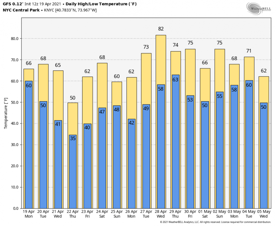
12Z GEFS claims today was the warmest day we will see for the next 15 days. Mean T goes up 5 degrees during this period so this would be sticker shock. There is a chance for an outburst about the 27th or so. Courtesy of WB.
-
The next 8 days are averaging 54degs.(47/61), or -1.0. Month to date is 52.7[+2.7]. Should be about 53.2[+1.3] by the 22nd. Looks dry after Sat. AM. 1.0"-1.5" rain to go. GFS again with a T of snow sometime---the 22nd this run. 48*(82%RH) here at 6am/7am(hazy blue) 52* by 9am. 59* by Noon. (thin overcast) 61* at 1pm. Reached 62* at 1:30pm but then sea breeze took over. Back to 57* by 3pm. Back up to 61* during 4pm-6pm. 58* by 10pm.
-
The next 8 days are averaging 53degs.(46/60), or about -1.0. Month to date is 52.6[+2.7]. Should be about 52.8[+1.5] by the 21st. 06Z GFS has 5 day heatwave now 4/24-28 with average high at 78. The attendent GEFS says we will have trouble reaching 60 during this same time frame. Keep up the good work boys. 2" of rain on all models for the next 10 days. 46*(84%RH) here at 6a, scattered overcast. 50* by 9am. 53* by 10am. 57* by 2pm, mostly sunny. 63* by 4pm. Reached 66* at 6pm. 60* by 8pm. 55* by 10m. 53* at 11pm.
-
The next 8 days are averaging 52degs.(45/58), or about -2.0. Month to date is 53.0[+3.3]. Should be about 52.5[+1.5] by the 20th. All models have 4" to 6" of rain over the next 10 days. 37/45 seems to be the range at the time possible snow may occur. But the nutty CMC has 31* out on the 21st.! 48*(87%RH) here at 6am, drizzle. 50* by 10am. 51* by 1pm. 51*/52* at 2pm. 49* by 6pm.
-
Second half of April? eke The rest of the week is in and out of clouds and showers, with snow Thurs. night for some nearby locations apparently.
-
The next 8 days are averaging 53degs.(47/58), or about -1.0. Month to date is 53.1[+3.6]. Should be about 52.8[+1.5] by the 19th. GFS/CMC have about 2" over the next 10 days and the EURO is headed toward 5" during this period. 55*(93%RH) here at 6am, FOG <0.2m. 59* by 1pm.
-
The next 8 days are averaging 50degs.(45/55)., or -3.0. Month to date is 52.3[+2.9]. Should be 51.2[a little AN] by the 18th. Rain has moved to the 15th. to the 17th. period. Very little before the 15th. now. Had quick lite shower yesterday about 4:30pm. Street looks wet this AM. BTW: CI rides etc. are open starting yesterday, supposedly by reservation. The Cyclone has been running with a full train, among other rides. Open now but ground fog comes and goes blocking my view. 52*(87%RH) here at 6am. (was 49* at 2am) 55* by 9am with breaks of sun. 57* at 10am. 59* by Noon. Back to 57* with ground level fog at 1pm. 56* at 2pm. 60* at 3pm. 62* at 4pm. (fog behaving and staying over water last 90mins. 54* at 9pm and FOG has totally taken over.
-
Days 11-15 and 16-20 both look like this and are colder than the so called wet snow of the 16th, which is already gone on the 18Z. Back on May 09, 1977, at about 7:30am, I saw huge snowflakes falling as my F Train was passing through the Smith & 9th. St. elevated station. By the time I got to the City and out onto the street it was already over. The 500mb heights in the Low overhead were 5275m, according to the historical map I just looked at.
-
And this they call the "new improved version" of the GFS:
-
The next 8 days are averaging 52degs.(47/57), or just Normal. Less than an inch of rain on all models again for 4/10 to 4/15. 50*(83%RH) here at 6am, overcast. 49* by 9am. Been 50* to 52* the last 6 hours.


