CIK62
-
Posts
5,227 -
Joined
-
Last visited
Content Type
Profiles
Blogs
Forums
American Weather
Media Demo
Store
Gallery
Everything posted by CIK62
-
The immediate southerly portion of storms has collapsed during the last hour. You have to go to Washington DC for the good stuff. Some rain within 30 mins.----for 30 mins.---- is all I think I am going to get:
-
For Liberty Bell: Compromise at 1:15pm.
-
The next 8 days are averaging 71degs.(62/80) or +5. Month to date is 61.5[-0.4]. Should be 64.1[+0.9] by the 30th. Reached just 83 here at 5:30pm. EWR 95, LAG 91, NYC 90, JFK 87. Today: 80-88, variable skies, wind w. to n., TS? between 6pm-midnight., 61 tomorrow AM. 74*(90%RH) here at 7am. 83* at Noon. 84* at 1pm. but 81* at 1:30pm. 78* at 2pm. 73* at 3pm. Back to 83* at 7pm.
-
At the 2:30pm peak for this map area: I was under 70* at this time !!!. Reached only 83* at 5:30pm.
-
The next 8 days are averaging 72degs.(62/82) or +6. Month to date is 60.7[-1.1]. Should be 64.0[+0.9] by the 29th. Reached 68 here yesterday. Today: 88-94, wind w., cloudy, foggy till Noon, then m.suuny, -10 degrees for coastal areas, 73 tomorrow AM. btw: That 'Nutty' T outburst from last evening, is down 15 degrees across the board now. Still 97,95 this weekend however. 61*(99%RH) here at 7am FOG<0.1mi. 68* here at 10am., hazy blue and about 5mi. visibility. Could not even see the early arrivals passing my building in the half-marathon till 9:30am. 72*(95%RH) at Noon. 74* at 1pm. 71*! at 2pm. 69*! at 3pm. 75* at 4pm. Finally hit 80* at 5pm. Reached 83* at 5:30pm. 79* at 7pm.
-
-
The next 8 days are averaging 73degs.(62/85) or +8. Month to date is 60.7[-0.9]. Should be 64 3[+1.7] by the 28th. Reached 68 yesterday. Today: 71-76, wind e. to s.,m. cloudy, rain late-till midnight, 67 tomorrow AM. I will say it again. The GFS---a model with no Quality Control or Self-Respect................. 59*(90%RH) here at 7am.{ 56 at 1am} 62* at 9am. 67* at 11pm. 63* at 1pm. 68* at 2:30pm. 62* at 4pm FOG<0.10mi.
-
The GFS finally steps off the top of MT. OLYMPUS........moves away from scaping 100. Well I forgot to mention it again---that today is the 60th anniversary of the highest T in May 99 in 1962. The day apparently started at 57. Anyone have the hourly figures for that day in Central Park? Thank You.......uncle W !!
-
The next 8 days are averaging 72degs.(62/83) or +7. Month to date is 60.7[-0.8]. Should be 64.2[+1.6] by the 27th. Reached 69 here yesterday. Today: 63-67, wind s. to n.w.,rain early, m. cloudy with breaks?, 62* tomorrow AM. Possible high T ranges for the weekend: Sat. Sun. 92-99 89-91 Deduct 10 to 20 degrees if you are near JFK, or in a similar environment. 56*(96%RH) here at 7am{was 55 at 6am.} 59* at Noon.
-
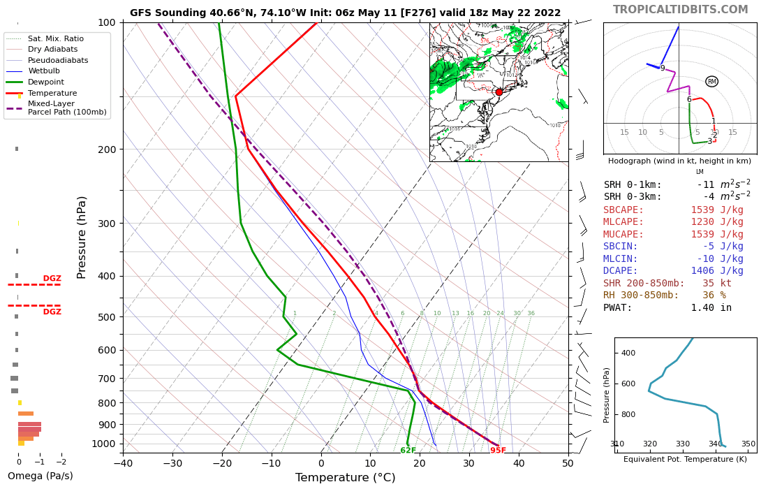
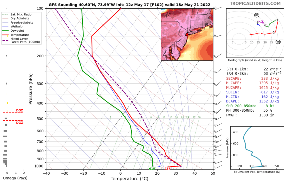
Check back Monday and see how your favorite model made out. As of latest runs available this evening. Some color to go with the forecasts. For the GFS: Looks like 20*C+ briefly for the 850mb T: Sat/Sun GFS 98,96 CMC 95,93 NDFD 92,90 NBM 91,89 ICON 88,89 EURO 87,74
-
The next 8 days are averaging 72degs.(62/83) or +6. Month to date is 60.5[-0.9]. Should be 64.1[+1.3] by the 26th. Since I am near the water, I could get screwed this weekend. EURO has JFK under 70 for the next 10 days!!! GFS has record heat on Sat./Sun., 99,98. EURO is 80,89. CMC is 91,93, but coolish every other day. Problem with the post processing of the MOS is what is behind this---would be my guess. Reached 79 here yesterday. Today: 66-71, wind w., m. sunny till the early afternoon, rain by 3am tomorrow, about 60 tomorrow AM. 57*(59%RH) here at 7am. 65* at Noon. 69* at 3pm. Reached 71* at 4pm. 62* at 7pm. 59* at 9pm.
-
But for JFK it has 71! 28 degree difference in less than 15 miles? GFS: The 90's Specialist. No quality control here. For me, it looks like this: Wind is SW and should limit sea breeze damage. Going to prepare for the beach and decide at the last moment probably.
-
The next 8 days are averaging 71degs.(60/81) or +6. Month to date is 60.1[-1.1]. Should be 63.8[+1.3] by the 25th. Reached 72 here late yesterday, 7pm, when there was finally a little shower. The flooding threat amounted to 0.12"--- not even the normal for 1 day. GFS is 98 on the weekend in CPK, but 77 at JFK. Your pick. 59*(78%RH) here at 7am. 68* at Noon. 71* at 12:30pm, but clouding up. 74* at 2pm, good n. west wind keeping T's uniform---this kind of setup will produce 90+ all around here this weekend, but........... 78*(28%RH) at 4pm. Reached 79*(26%RH) at 5:30pm.
-
Now to look at this one would think I just experienced a heavy shower..........but it was just some wind and the street did not even get wet............nor was there any thunder even. What gives----a mid-level shower that does not reach the surface?
-
The next 8 days are averaging 65degs.(59/71) or +1 Month to date is 59.6[-1.5]. Should be 61.5[-0.6] by the 24th. Big drop from yesterday's ADS's run. lol Reached just 67 in the fog here yesterday. Today: 70-75, wind s. to w., clouding up, rain and some TS? between 5pm-8pm., 58* tomorrow AM. 66*(99%RH) here at 7am, variable fog, hazy blue. but 61*(92%RH) at 8am. Back to 66* at 9am. 68* at Noon. 63*-70* during last 4 hours, 4pm. Reached 72* at 7pm. 64* at 9pm.
-
The next 8 days are averaging 73degs.(62/84) or +9. Over the next 10 days the highest T is 99 on the GFS, 84 on the CMC, and just 80 on the EURO again. GFS has been the star here for a week. The projection below is always based on the GFS so it could be wack-a-doo. Month to date is 59.0[-2.0]. Should be near 64.0[+2.0] by the 23rd. Reached 67 yesterday. Today: 68-75, wind w.-n.w., breaks in clouds by 1pm, 64 tomorrow AM. 58*(99%RH) here at 7am FOG <0.10mi.{was 57-60 overnight} 62* at 9am, still foggy. 68* at 11am and still foggy, but lifted some. 69* at Noon, fog mostly gone, some clouds, but 66* at 1pm. 65*-67* during last 3 hours, with good sun-but continually varying fog, 4pm.
-
A Hot Quickie on all the models. "ALEX" could pass by near the end of the period too.
-
The next 8 days are averaging 69degs.(59/78) or +5. Month to date is 58.5[-2.3]. Should be 62.5[+0.5] by the 21st. Reached 69 here yesterday. Today: 64-69, wind s.e., cloudy, fog, rain after 3pm. GFS,EURO have the 90's next weekend. CMC just 80. GFS has the most rain through Tues. now at about 1". It had the least formerly. JWB, April 26, 1865...... ......."USELESS, USELESS". 59*(99%RH) here at 7am, FOG <0.2mi. 65* at 10am. 67* at 11am. Fog variable. 59* at 8pm.
-
The next 8 days are averaging 69degs.(59/78) or +5. Month to date is 58.0[-2.7]. Should be 62.4[+0.4] by the 21st. Reached 69 here yesterday. Today: 65-70, wind e., cloudy, fog early,60 by tomorrow AM. HW Warning on again for May 20, 21, 22. Near 100x3??? Short, but spectacular---like May 19, 1962? 60*(99%RH) here at 7am, Fog<0.5mi. 62*/63* at 10am and still foggy. 68* at Noon, fog lifted.
-
The next 8 days are averaging 68degs.(59/76) or +4. Month to date is 57.2[-3.4]. Should be 61.7[-0.3] by the 20th. Reached 73 here yesterday. Today: 65-70, wind e., m. cloudy, 60 tomorrow AM. Friday to Tuesday could be variable clouds and drizzle. GFS spreads out P amounting to 0.20". CMC is 5x this. EURO is 0.50". Last four runs of GFS for May 21: 98 down to 74. The 98 is down from 100-----the EURO was 64 on that run. The atmosphere is pulling the panties and dirty underwear off these models to reveal all their 'foibles'(Rated G not XXX)! 58*(79%RH) here at 7am.{was 57 overnight} 61* at 9am. 62* at Noon. 64* at 2pm. Reached 69* at 5pm. 62* at 6pm., FOG <0.5mi. 60* at 8pm.-still foggy.
-
The next 8 days are averaging 66degs.(58/74) or +3. Month to date is 56.5[-3.9]. Should be 60.7[-0.9] by the 19th. Reached 73 here yesterday. Today: 65-70, wind e. and breezy early, increasing cloud cover, 57 tomorrow AM. As I predicted 5 days ago (file has been archived) when the GFS replaced 70's with 90's for one run ( a total of 4 90's)---that it would not be long before it showed the first 100. Well it has happened: Pesty showers Sat. to Tues. Some of this is actually last week's stuff-come back! Potential for 80 if clouds stay away Sun./Mon.? 55*(33%RH) here at 7am. 62* at 10am. 68* at Noon. 72* at 2pm. 73* at 2:30pm then strangely enough the sun came out full and stayed out......but T went down to 64*(62%RH) at 3:30pm! 66* at 4pm.
-
The next 8 days are averaging 65degs.(57/73) or +2. Reached 75(21%RH) here yesterday with the northerly wind. Month to date is 55.9[-4.4]. Should be near 60.2[-1.4] by the 18th. Today: 63-67, wind n.e. and breezy, p. sunny, low 50's tomorrow AM. 53*(32%RH) here at 7am. 56* at 9am. 61* at 11am. 63*(25%RH) at Noon. 71*(24%RH) at 3pm. 73*(23%RH) at 3:30pm. Has clouded up and the T, like the markets, has gone Downtown.......... 68*(37 %RH) at 4pm. 64*(42%RH) at 4:30pm. 60* at 8pm.
-
The next 8 days are averaging 64degs. (53/75) or about +2. Reached 62 here yesterday. Today: 65-70, wind n. and breezy, m. sunny, 49 tomorrow AM. Dry till the weekend. 48*(36%RH) here at 7am{was 46 at 5am}. 52* at 9am. 60* at Noon. 70*(24&RH) at 3pm. 72*(23%RH) at 3:30pm. Reached 75*(21%RH) at 5:30pm. 60* at 10am. 58* at 11pm
-
Only the GFS has an 80 degree day in the next 10: