Upstate Tiger
-
Posts
702 -
Joined
-
Last visited
Content Type
Profiles
Blogs
Forums
American Weather
Media Demo
Store
Gallery
Everything posted by Upstate Tiger
-
We’ve been stuck at 34/26 for last couple of hours. Wished I could stay up a couple more hours as I think we get a few flakes and some sleet before WAA takes over.
-
Temp falling like cheap lard in Cherryville. Down to 36/27 at 643. About 5 degrees colder than prog’d. Hmmm
-

Mid to Long Range Discussion ~ 2024
Upstate Tiger replied to buckeyefan1's topic in Southeastern States

-
Mid to Long Range Discussion ~ 2024
Upstate Tiger replied to buckeyefan1's topic in Southeastern States
The Pacific looks like its not going to cooperate. Will have to rely on HL blocking IMO. -
Mid to Long Range Discussion ~ 2024
Upstate Tiger replied to buckeyefan1's topic in Southeastern States
Ops not showing anthing to hang our hats on but with active pattern, arctic air in our hemisphere, blocking posibly showing up, who knows? It only takes one -
Mid to Long Range Discussion ~ 2024
Upstate Tiger replied to buckeyefan1's topic in Southeastern States
Looking at the last 24 hours of model runs leads me to believe the next 2-3 weeks are going to be a wild ride. -
Mid to Long Range Discussion ~ 2023
Upstate Tiger replied to buckeyefan1's topic in Southeastern States

-
Mid to Long Range Discussion ~ 2023
Upstate Tiger replied to buckeyefan1's topic in Southeastern States
European with a little something for next week. Temps need a little help.
-
Mid to Long Range Discussion ~ 2023
Upstate Tiger replied to buckeyefan1's topic in Southeastern States
Looks like a couple of opportunities over the next couple of weeks to track. Would love to see the pattern follow 79-80 given a possible relaxation. Snow and cold first week of January. 2 weeks of mild followed by a historic February. -
Mid to Long Range Discussion ~ 2023
Upstate Tiger replied to buckeyefan1's topic in Southeastern States
I'm a glass half full guy usually looking for some silver lining but the LR this morning is not good. Once again the Pacific is really screwing us in the east. This time it's causing mild Pacific air to flood Canada over the next couple of weeks. I'm always optimistic when Canada has cold air. When it doesn't, it's no bueno. -
Mid to Long Range Discussion ~ 2023
Upstate Tiger replied to buckeyefan1's topic in Southeastern States
Temps in Canada look better with afternoons runs for week of Christmas. This coincides with pattern change many have referenced. Probably not going to help us with next weekend and midweek storm afterwords but we’ll see. -
Mid to Long Range Discussion ~ 2023
Upstate Tiger replied to buckeyefan1's topic in Southeastern States
Both overnight GFS runs show opportunities beginning next weekend. The concern is the surface maps. Canada is pretty much devoid of arctic air on the 06Z. -
18 in Cherryville this morning. Pretty cold for the Piedmont in November.
-
Mid to Long Range Discussion ~ 2023
Upstate Tiger replied to buckeyefan1's topic in Southeastern States
Lots of cold air building in Canada over the next 10-14 days...poised to move into the west it looks like Can't catch a break with the PNA, at least yet. But hope springs eternal when it is only 6 hours until the next run... -
Mid to Long Range Discussion ~ 2023
Upstate Tiger replied to buckeyefan1's topic in Southeastern States
From KGSP. Will be a mess for early travelers, but we need the rain! This should kick off an active couple of weeks. This high will remain transitory into Mon and ridge down the east into the FA maintaining near normal temperatures. Meanwhile, northern stream Pac energy combines with the srn STJ over the West in a split flow regime, which then creates a well defined and deep mlvl trof across the MS Valley by Mon night. This trof will be highly dynamic as deep layered shear nears 100 kts and combines with good GOM moisture flux and creates a good set-up for sigfnt rainfall and possibly a few organized thunderstorms across the srn half of the area. There`s remains uncertainty with the amt of destabilization ahead of the llvl forcing, but the model trends are going up with the ECMWF and CMC models indicating arnd 200 J/kg of sbCAPE within the warm sector during max heating. So a high shear / low CAPE strong storm environment is looking more possible. Soundings also show very high levels of 0-3 km helicity (>600 m2/s2), however, this is mostly due to the aforementioned sfc wedge producing ne/ly at the sfc. But as usual, the wedge bndry areas will suspect for more organized cell development. In any case, this system looks to be a good precip producer, the best in the last few months, with possibly 1.5 to 2.0 inches of rain over many areas thru Tue night. With high cloud cover and ne/ly flow, highs Mon thru Wed will be held abt 5 degrees below normal with lows averaging arnd normal. -
Mid to Long Range Discussion ~ 2023
Upstate Tiger replied to buckeyefan1's topic in Southeastern States
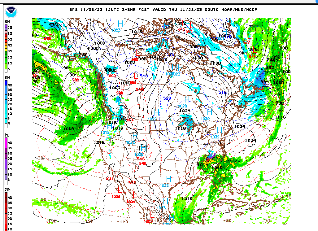
If the 12 GFS is to be believed, we enter a very active period beginning next Tuesday through the end of the run. Hoping it is right this time and we get the storms showing up on this run. https://mag.ncep.noaa.gov/Imageanis.php -
Mid to Long Range Discussion ~ 2023
Upstate Tiger replied to buckeyefan1's topic in Southeastern States
Thanksgiving fantasy. Honestley, I'd take anything wet falling from the sky.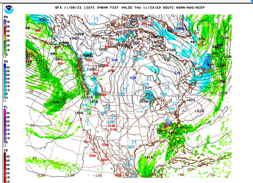
-
Mid to Long Range Discussion ~ 2023
Upstate Tiger replied to buckeyefan1's topic in Southeastern States
Looks like we could get a coastal low on Sunday. Not a moment too soon. .LONG TERM /SATURDAY NIGHT THROUGH MONDAY/... As of 110 PM EDT Tuesday: Rainfall will continue on Saturday as the surface front makes its way across the region...likely exiting to the southeast by late Friday night or early Saturday morning. Thereafter, deterministic guidance continues to depict it stalling, whereupon a robust upper shortwave will arrive and instigate cyclogenesis along the Carolina coast. This`ll give us another shot at some rainfall...with the new QPF forecast giving the SC zones another 0.25" or more on Sunday and Sunday night (more than half an inch per the 12z GFS, which ironically has trended toward stronger cyclogenesis than the ECMWF after barely developing the feature at all on the 06z cycle). All things considered, while this rain won`t quiet offset the ongoing drought, it`ll bring some much-needed moisture to the region.
-
33 in Cherryville in the piedmont of NC. No frost as winds were too brisk.
-
Mid to Long Range Discussion ~ 2023
Upstate Tiger replied to buckeyefan1's topic in Southeastern States
Like seeing the CPC 8-14 day hazard map with the blue here https://www.cpc.ncep.noaa.gov/products/predictions/threats/threats.php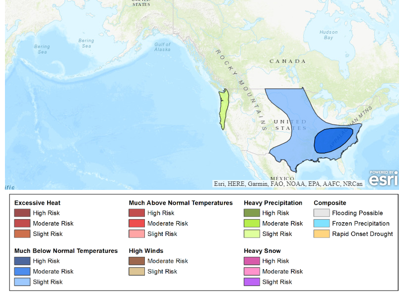
-
Mid to Long Range Discussion ~ 2023
Upstate Tiger replied to buckeyefan1's topic in Southeastern States
Hmmm. Another cold shot in two weeks after next weeks cold shot?
-
Finally saw our first patches of frost here in Cherryville this morning. Wasn't widespread but rooftops and yards in the low lying spots were white.
-
Mid to Long Range Discussion ~ 2023
Upstate Tiger replied to buckeyefan1's topic in Southeastern States
I was a senior in college in 87/88 and October was really cold in the upstate. I think GW posted a correlation between BN October’s in EN and wintery precip. I remember many days going to lunch with temps in the low to mid 50s. We had snow flurries on Halloween and big snow in January. 86/87 was a EN year too but don’t remember October being cold. Of course JFM were really good that year. -
Mid to Long Range Discussion ~ 2023
Upstate Tiger replied to buckeyefan1's topic in Southeastern States
Finally starting to see some colder air filter into central and western Canada at the end of the month and beginning of October. -
Mid to Long Range Discussion ~ 2023
Upstate Tiger replied to buckeyefan1's topic in Southeastern States
It’s never right at this range with a winter storm but watch it be right with a cat 4 hurricane.