Upstate Tiger
-
Posts
701 -
Joined
-
Last visited
Content Type
Profiles
Blogs
Forums
American Weather
Media Demo
Store
Gallery
Everything posted by Upstate Tiger
-

Mid to Long Term Discussion 2019
Upstate Tiger replied to Upstate Tiger's topic in Southeastern States
Yes but with so much of the country AN to our north and west, it won’t make much difference for us unfortunately. Not a big deal really. We really don’t start seeing any relief in the SE until after mid month anyway -
Mid to Long Term Discussion 2019
Upstate Tiger replied to Upstate Tiger's topic in Southeastern States
CPC out this afternoon with 14 day outlook and is not good if you want a cool down. Large are of central and eastern US in the deep reds. They are favoring the European with strong ridging versus GFS and troughiness. Since the heat always verifies in the long range and long range cold is like pixie dust, I am sure the heat will verify. https://www.cpc.ncep.noaa.gov/products/predictions/threats/threats.php -
Mid to Long Term Discussion 2019
Upstate Tiger replied to Upstate Tiger's topic in Southeastern States
Has anyone else had trouble accessing KGSP AFD? It has not been updated since Wednesday evening.... -
Mid to Long Term Discussion 2019
Upstate Tiger replied to Upstate Tiger's topic in Southeastern States
"Do not seek the treasure!" -
Mid to Long Term Discussion 2019
Upstate Tiger replied to Upstate Tiger's topic in Southeastern States
You know this season seemed to have so much promise. We seemed to have all the right players in place. Most of the experts predicted a rockin January, February and even March. After sitting pretty during the first week in December, the season never seemed to get back on track. We were told things would turn around in January. Then we were told things would turn around in February. Finally, we were told that March would be our month. Mercifully, NC State ended the Clemson basketball season today! -
Mid to Long Term Discussion 2019
Upstate Tiger replied to Upstate Tiger's topic in Southeastern States
You guys better watch it or Burns will put you on Double Secret Probation. -
Mid to Long Term Discussion 2019
Upstate Tiger replied to Upstate Tiger's topic in Southeastern States
Was it over when the Germans bombed Pearl Harbor???? -
Mid to Long Term Discussion 2019
Upstate Tiger replied to Upstate Tiger's topic in Southeastern States
Not good trends today for sure but still far from being settled. Below is long term AFD from GSP: At the surface, a low pressure system develops to our west on Sunday in response to the digging trough. Moisture and precip spread back into the area as the low moves east. However, the ECMWF is stronger, wetter, and farther north with the surface low. Therefore, it shows little in the way of wintry precip until the low pulls away on Monday with some brief NW flow type snow for the mountains. The thermal profiles suggest more of a mixed p-type scenario if enough low level cold air could move in Sunday night. The GFS still has widespread precip but is also colder with the low track closer to the Gulf Coast. That said, the cold air doesn`t move in until the back side of the low keeping any wintry precip confined mainly to the mountains, with some spillage out across the I-40 corridor Sunday night and again Monday night as the low is departing. The GFS indicates a potential mixed p-type problem initially turning to a rain or snow scenario as the colder air moves in. The GFS ensemble mean shows a rain or snow scenario with up to an inch of snow outside of the mountains with up to 4 inches across the mountains, but there is a wide spread in individual members across the area. Given the above problems, have limited any p-type concerns to rain or snow, but this is subject to change as the event approaches. Also, limited PoP to the chance range for any one period. The models also show a lingering inverted surface trough across the area for Tuesday. The ECMWF is dry while the GFS has light precip over the area in response. I have kept the forecast dry for now given the uncertainty. Model blend temps have come in warmer through the period, but blended with the previous forecast to avoid some big changes in the forecast. The warmer temps would limit the amount of wintry precip outside of the mountains as well. However, there are good indications of a cooling trend through the period. -
Mid to Long Term Discussion 2019
Upstate Tiger replied to Upstate Tiger's topic in Southeastern States
Well the northwest and Midwest are having epic winters. Cold and winter storms just set up west and north of us this year. Maybe we still get something this year. If not, maybe next year -
Mid to Long Term Discussion 2019
Upstate Tiger replied to Upstate Tiger's topic in Southeastern States
GSP keeps some idea of a wintry event next week for parts of the area. BTW...where are all the regular posters? This place is as dead as Williams Brice in the 4th quarter of Clemson - South Carolina game. The EC forecasts a stronger high to our north channeling in cool air as the deep moisture passes Tuesday and Tuesday night. Thus quite cool and quite wet with some wintry precip possible for northern parts of the mountains and foothills. Low pressures riding a front out of the Gulf will not move east of our area until early Thursday which is after the end of the current forecast period. -
Mid to Long Term Discussion 2019
Upstate Tiger replied to Upstate Tiger's topic in Southeastern States
From GSP AFD long term forecast: Monday night thru Tuesday...the cool air may set the stage for a wintry mess with the next storm system. The southern stream jet will start to amplify and lift northward slightly, placing strong entrance region upper divergence over the Southern Plains. So the signal is fairly strong on a very wet storm system developing somewhere across the southern states, bringing plenty of moisture into the region around New Day 7. Both the EC and GFS show a strong CAD developing and thicknesses supporting a mixed bag of precip types across much of the NC mountains and the I-40 corridor to the east. PoPs ramp back up to high-end chc to likely with temps mainly in the 30s to mid 40s. -
Mid to Long Term Discussion 2019
Upstate Tiger replied to Upstate Tiger's topic in Southeastern States
You know what that silly clown map reminds me of? The 93 Superstorm......aaahhh the memories. I guess that's all we're left with now! -
Southeast Sanitarium - A Place to Vent
Upstate Tiger replied to Jonathan's topic in Southeastern States
Well I just renewed my American Weather subscription for another year. If I don't get any snow by the end of March, can I get a refund? -
Mid to Long Term Discussion 2019
Upstate Tiger replied to Upstate Tiger's topic in Southeastern States
Right on cue, the NAO looks to go negative at the end of the month, hopefully soon enough to give the SE one more opportunity for a winter storm. More than likely it just means another cold wet spring. It seems like I have put down mulch and a aerated my yard in a cold rain each spring for the last 5 years. LOL https://www.cpc.ncep.noaa.gov/products/precip/CWlink/pna/nao_index_mrf.shtml -
Mid to Long Term Discussion 2019
Upstate Tiger replied to Upstate Tiger's topic in Southeastern States
Sorry. Just being sarcastic with something I saw posted on Facebook earlier today. -
Mid to Long Term Discussion 2019
Upstate Tiger replied to Upstate Tiger's topic in Southeastern States
Good news snow lovers! Some of my S.C. friends told me that WYFF said yesterday that the cold weather is over for this winter and an early spring is coming. -
Mid to Long Term Discussion 2019
Upstate Tiger replied to Upstate Tiger's topic in Southeastern States
I can't wait for CR to post these graphics in a month when it shows our annual springtime negative NAO! -
Mid to Long Term Discussion 2019
Upstate Tiger replied to Upstate Tiger's topic in Southeastern States
Well at least this weekend's storm looks to lay down some pretty good snow in the Midwest, on top of some areas that just got snow earlier this week. This should lay down the tracks for the cold air to come south without a lot of moderation. I know what the ops are showing but I am still not a 100% convinced the system late next week goes as far north as modeled. A lot of moving parts in play after this weekend make it hard to have faith in any specifics beyond 5 days. We do know, however, that there will plenty of cold air, s/w's entering the west and more favorable indices. I wouldn't jump off the cliff just yet..... -
Mid to Long Term Discussion 2019
Upstate Tiger replied to Upstate Tiger's topic in Southeastern States
Sure hope the latter comes to fruition Grit. The CPC 14 day outlook sucks this afternoon, although the NAO does look to go negative at the end. Of course, the possibility of a winter storm in the southeast this weekend shows how quickly things can change around here! Now, if only the Tigers can make a good showing tonight I'll be happy with whatever happens over the next couple of weeks.... -
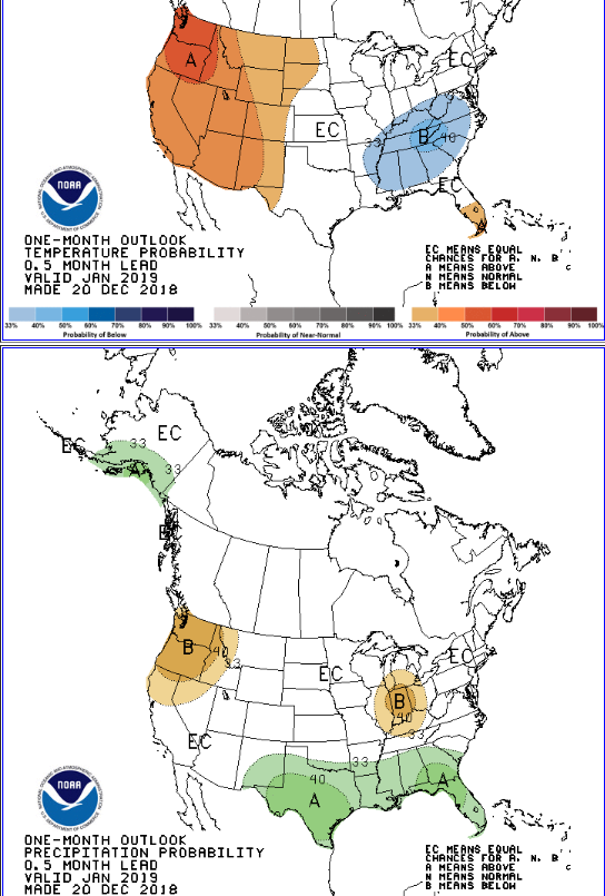
In my 7 years on here I have never started a thread. Maybe I can bring the MoJo. Indices and forecasts seem to be lining up for a wintry January in the Southeast.

-
December 8-10, 2018 Winter Storm
Upstate Tiger replied to Orangeburgwx's topic in Southeastern States
For those interested, here is the AFD from KGSP: https://forecast.weather.gov/product.php?site=NWS&issuedby=GSP&product=AFD&format=ci&version=1&glossary=1&highlight=off -
Snow pack is building nicely over the Northern Rockies and Northern Plains in the next week or so. Models hinting at some moderation in temps in the Southeast around the 15th. Hope that doesn't get pushed back. Ready for some fall temps. http://www.cpc.ncep.noaa.gov/products/predictions/threats/threats.php
-
Yep, it's the 3rd year in a row without traditional "fall", at least so far. In 2016 we had the warm fall and all the forest fires, 2017 was just plain warm until the 2nd week of November and this year has also been above average to date. Maybe see a cool down after next week. Highs in the 30's are starting to show up later this week in Montana and Wyoming.
-
Yep! They have a difficult job covering three different geographical areas and they are the best IMO. Just look at the complexity of this one event....