

Upstate Tiger
-
Posts
703 -
Joined
-
Last visited
Content Type
Profiles
Blogs
Forums
American Weather
Media Demo
Store
Gallery
Everything posted by Upstate Tiger
-
Obviously there is some science behind this annual ritual. Perhaps when I get a little less busy at the hospital I will do some research as to why we see the NAO go negative each spring but not from December to February. At this point it can't be coincidental or can it? What atmospheric conditions are causing the teleconnections to get stuck in this same pattern? During the 70's and 80's we had a predominantly negative NAO, now it seems we have flipped the script. https://www.cpc.ncep.noaa.gov/products/precip/CWlink/pna/nao_index_mrf.shtml
-
Not a stellar winter IMBY. We moved up to Gaston County from upstate in Jan. 2017 and had a 5" snow the first week we were here. Rest of that winter was terrible for winter weather. 17/18 we had the snow in December and snow and cold in January so it was a good winter. 18/19 we had 5" of snow in Dec. but nothing rest of winter. This year nada. However, this year wasn't as bad as 11/12. That was the worst winter since I started following winter weather in the SE in the mid 70's and believe me, I have seen some sucky winters. Not even one thing to track. I should add that we live in N. Gaston County near Lincoln County line. Of course, it wouldn't matter if I moved to Syracuse, NY, I seem to cause a snow drought wherever I go these days and heaven forbid I post about a potential event
-
Yep. I was a senior in high school in Easley S.C. in 83. Front came through on Wednesday and brought flurries after a warm week. Thursday was gray and cold with a strong NE wind. We had baseball practice in 42 degree windy weather that day. Try hitting a baseball with an aluminum bat in that weather. Friday morning the snow hit. 10” of wet snow. Some of the biggest flakes I’ve ever seen. Was an El Niño winter. Except that big snow it really wasn’t a snowy winter.
-
Wound up with just a dusting in Cherryville unless we get wraparound from coastal. Congrats to our Raleigh folks. GA and NW corner of SC along with central and eastern N.C. have now had snow. Now we need a I 85 special for us foothills and piedmont folks.
-

One More Shot: Feb 20-21 Event
Upstate Tiger replied to Tar Heel Snow's topic in Southeastern States
I don't get some of the wailing and gnashing of teeth. Radar returns west all the way into Ms. look pretty robust. I suppose the orientation and movement could result in some down-sloping. But I am just glad to have something to track after this crappy winter. Two weeks ago at this time we were hunkered down in the Emergency Operations Center with an EF2 tornado on the ground in the southern part of the county headed our way. It's sleeting outside now. Quite a difference. No complaints here......yet -
Rain and sleet in Gastonia and 42. Little surprising to see sleet this early with temp at 42
-
One More Shot: Feb 20-21 Event
Upstate Tiger replied to Tar Heel Snow's topic in Southeastern States
Yep. Dropped from 52 to 48 here in Cherryville since 430 PM, mostly clear now, and stiff NE wind. -
One More Shot: Feb 20-21 Event
Upstate Tiger replied to Tar Heel Snow's topic in Southeastern States
GSP AFD.....they are slowly increasing confidence in an event Thursday... All told, the best 2 to 3 inch snow accumulations for this relatively short duration event should affect the higher ridges of the NC mountains, with lighter accumulations east of the mountains and mainly northwest of I-85, but with a dusting southeast of the Interstate. Some wintry weather potential will be featured for most zones in the HWO this afternoon, but no Watches will be posted at present. https://forecast.weather.gov/product.php?site=NWS&issuedby=GSP&product=AFD&format=ci&version=1&glossary=1&highlight=off -
For those discounting NAM, do so at your own peril. Many times I’ve seen it out perform globals on SE winter storms. Feb 2014 is just one example. While European and others were calling for a snow apocalypse, NAM was screaming “the profiles are gong to be too warm for many”. It was exactly right. I am hoping it is right this time by forecasting the opposite.
-
https://www.cpc.ncep.noaa.gov/products/precip/CWlink/pna/nao_index_mrf.shtml Let me save you the trouble of clicking: NAO - Not suitable for small children AO - Don't look Ethel....at lease moving toward 0 after this week PNA - See AO Given the horrific indices this winter, it's amazing we have gotten any frozen precip. at all in the SE.
-
I'll start a thread tomorrow....
-
As crazy as this month has been already, who knows??? It is possible we could time up a winter storm on the backside of one of these monsoons since there is cold air in NA, albeit on the wrong side of the continent.
-
Congrats to all our peeps in GA and S.C. that scored today, especially the NW corner. Who knew northern GA was the place to be for snow in the SE. For the rest of us we better hope we can squeeze out a surprise this upcoming weekend. Looks like the western trough and SE ridge come back with a vengeance the following week.
-
Wished I was home to see it. Ground almost completely covered with some on the roads and drive.
-
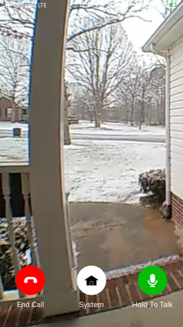
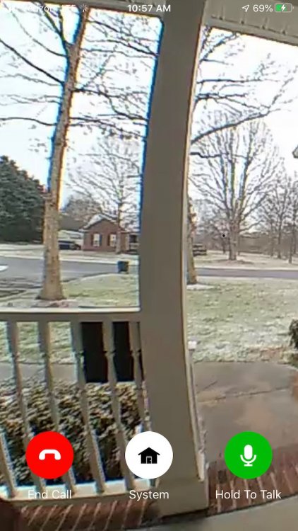
View from security camera at home in Cherryville. Good bit of white on the ground. Wife said roofs and grassy services covered. Just sleet and snow here at work in Gastonia
-
I feel bad for the younger posters. I was born in the 60’s and I would say from about 62 to 88 winters like 09/10 were the rule not the exception. In fact I remember snow on the ground in the upstate most of January in 77,78, 79, 82, 87, 88 and 80 and 83 were epic late season. We also had at least one single digit cold outbreak each winter. The last comparable winters to that were 09/10 and 10/11 in terms of multiple events. I guess 13 and 14 had a few events also. Sure miss the parade of Miller A’s each winter.
-
That's one crazy wind field. If that happens, better get your generator ready.....
-
Yep, the real cold is still locked up in Canada during this time. If the GFS is to be trusted, it shows a pretty good push of cold air south from Canada but not until the after this storm has passed. Still, something to keep an eye on as well as the following week (1st week of Feb.) with cold on the move.
-
Yeah right....I stand a better chance of seeing us beat the Tarheels in Chapel Hill than ever seeing a storm like that again.
-
Wow, posters on here are like Clemson defensive backs this morning....no where to be found! Surprising given the potential. Headed to Asheville this weekend, may see some token winter precip. early Saturday.
-
Awesome! Thanks for clarifying
-
Grit, Great stuff. Question, are the MJO plots/forecast based on ops/ensembles model data or actual obs? Reason I ask is that you referenced last Feb. I don’t recall the models giving us a sniff last Feb. or is my memory flawed?
-
LOL. I’m supposed to fly to Milwaukee for a business trip on the 28th. Might need to pack a jacket.
-
Super cold air in Canada over the next 10 days. While heights certainly rise over the west after next weekend, that negative PNA is hanging in there like a hair on a biscuit. At least there are some signs of a pattern change. Hopefully we see some solid model evidence in the next few days.
-
Good post Q. The cold coming east after the 16th or so is being pretty consistently modeled. Have no chance at significant winter storm in the SE without cold in the eastern half. Pretty frustrating seeing Portland getting ready for potential winter storms over the next 7 days when their annual average snowfall is 3".


