Upstate Tiger
-
Posts
702 -
Joined
-
Last visited
Content Type
Profiles
Blogs
Forums
American Weather
Media Demo
Store
Gallery
Everything posted by Upstate Tiger
-

Winter Storm Izzy Obs Thread
Upstate Tiger replied to Prismshine Productions's topic in Southeastern States
41/27 in Cherryville here in the western Piedmont. DP has continued to drop all morning on a stiff NE wind. -
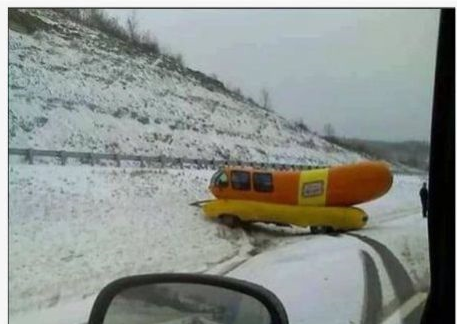
From GSP AFD "In classic Carolina winter storm fashion, cold air will be reinforced, if not enhanced Sunday morning by developing classical (or at least strong hybrid) cold air damming, as 1030-ish mb surface high pressure moves into New England beneath confluent upper flow." I know some are disappointed but for the older ones on the board, this is a classic SE winter storm that we experienced so often in the 60's, 70's, and 80's. Unless you were in the mountain, you got a few inches of snow, followed by sleet, and then freezing rain. You wake up the next day to a winter wonderland with the pines all encrusted in snow and ice.
-
Mid to Long Range Discussion ~ 2022
Upstate Tiger replied to buckeyefan1's topic in Southeastern States
Looks like an arctic outbreak after next weekend's storm on the 20th/21st. https://www.cpc.ncep.noaa.gov/products/predictions/threats/threats.php -
Thanks for posting Hky. Been some talk of a March 1980 analog. Saturday March 1, 1980, the upstate had a raging sleet storm all day with temps in the 20's while NC got hammered with snow. The upstate did pick up 4" of snow that Saturday night on the back side that made for good sledding.
-
Mid to Long Range Discussion ~ 2022
Upstate Tiger replied to buckeyefan1's topic in Southeastern States
One thing is for sure, the GFS has been pretty consistent with the monster storm around the 23rd and a really cold outbreak to follow. It’s been showing this for several days with little deviation. -
Mid to Long Range Discussion ~ 2022
Upstate Tiger replied to buckeyefan1's topic in Southeastern States
If this happens, they will be wearing 2 pairs of pajamas in the Cherryville Walmart...
-
Mid to Long Range Discussion ~ 2022
Upstate Tiger replied to buckeyefan1's topic in Southeastern States
Be patient low elevation peeps. There should be some opportunities over the next 2-4 weeks. -
Mid to Long Range Discussion ~ 2022
Upstate Tiger replied to buckeyefan1's topic in Southeastern States
Looks like winter pulled a UCLA in December and decided not to show up. -
Mid to Long Range Discussion ~ 2022
Upstate Tiger replied to buckeyefan1's topic in Southeastern States
Looking at the models for the next 2 weeks, Jan. 2 thru Jan. 6 is about the only period I see a slight chance for something frozen in the SE. During that period, there is cold air in the Midwest, the NAO remains negative, and the PNA relaxes a bit. I know...I am grasping at straws LOL. -
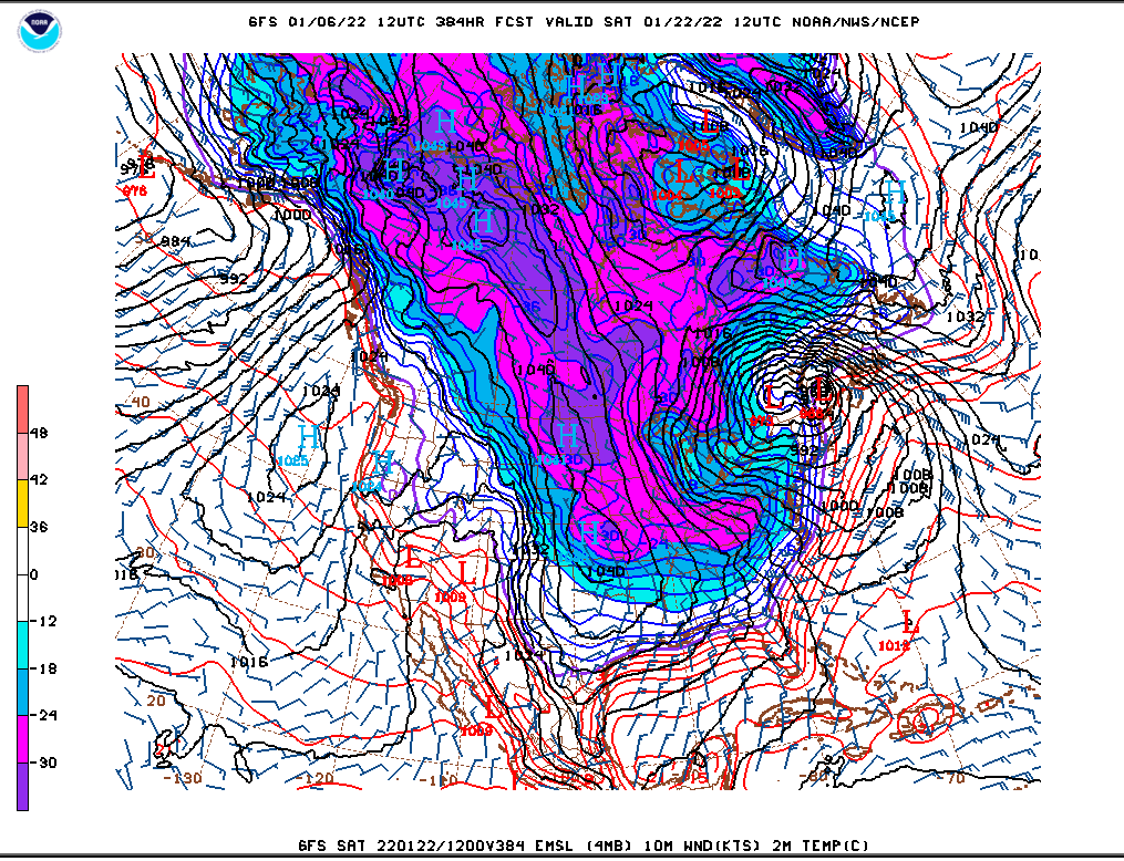
The super cold air in central and western Canada looks to be on the move south after New Years. How far south and east it goes is the question. At least we have cold air on this side of the hemisphere. Any buckle in the jet stream will open the flood gates. https://mag.ncep.noaa.gov/model-guidance-model-parameter.php?group=Model Guidance&model=GFS&area=NAMER&ps=area#
-
I caught a bit of the news tonight and it’s heartbreaking to see what our neighbors in Kentucky and the other states are going through. Kinda hard to root for a pattern change that would bring more misery to those poor people. For once, I’d be happy to see above normal temps and no precipitation.
-
NAO forecasts continue to show negative trends after next weekend while the PNA shows positive trends during the same time. May just be a temporary trend or signs of a real pattern change. At this point, it's about the only thing SE winter weather lovers can hope for... https://www.cpc.ncep.noaa.gov/products/precip/CWlink/pna/nao_index_mrf.shtml
-
Yes. If we could just get the PNA to move to neutral, I think we could see some opportunities in the south. There are some subtle signs that the PNA is moving toward neutral after next week. Will it get there? Who knows?
-
Or Seattle or San Diego.
-
Forecast to be below freezing each morning for the next 10 days IMBY. That will get rid of what bugs remain. Unfortunately, it looks dry. Very Nina like...
-
Looks like mountain peeps get some November accumulating snow Wednesday night and Thursday. https://forecast.weather.gov/product.php?site=NWS&issuedby=GSP&product=AFD&format=ci&version=1&glossary=1&highlight=off
-
2021-2022 Fall/Winter Mountains Thread
Upstate Tiger replied to BlueRidgeFolklore's topic in Southeastern States
The first snow map of the season. Awesome!! -
Looks like some could see their first freeze next week. NAO looks to continue in negative territory where’s it been for a while but the PNA is heading back down also.
-
39 this morning. Our first morning in the 30s here in the western Piedmont. 66 this afternoon. Great day to be outside.
-
Nothing much in the long term to indicate our first frost in the SE before at least third week of October. However, in a shocking development, the west is progged to be much below normal over the next two weeks. Maybe this signals a reversal in winter fortunes this year. Last year I remember taking some cold rides in October and November. https://www.cpc.ncep.noaa.gov/products/predictions/threats/threats.php
-
Read where the CPC is predicting 70% chance of weak La Nina from November through January. Weak La Nina's, generally speaking, are much better for the southeast than moderate or strong La Nina's. Years with weak LN's that produced bouts of wintry weather in the Southeast include 95/96, 83/84, and 00/01. Interestingly, 10/11 and 84/85 were moderate LN years and those were pretty active winters for the SE. Who knows. Not sure what I will see next...A SE snowstorm or a Clemson touchdown.
-
I am by no means the ENSO expert some on here are but it seems there is significant cooling in the 3.4 region of the pacific which would indicate another La Niña for late fall through winter. CPC has issued a Nina watch. Last winter was frustrating for winter lovers in the SE. It seemed the plains, Midwest, Tenn Valley and even mid Atlantic and NE had significant winter weather while we were under the curse of the SE ridge. Hopefully there is no repeat for this winter.
-
Left Myrtle Beach at 1130 AM and drove home to Cherryville. Temps were 92 or 93 from Florence through Hartsville, Pageland, and Lancaster. Rose to 95 in Rock Hill. That was highest I saw all day. Arrived home around 330 PM. It was 91 here in Cherryville.
-
Haven't you heard...it only snows now when it is 34 degrees F or higher
-