Upstate Tiger
-
Posts
703 -
Joined
-
Last visited
Content Type
Profiles
Blogs
Forums
American Weather
Media Demo
Store
Gallery
Everything posted by Upstate Tiger
-
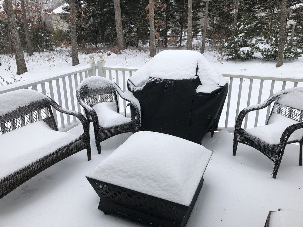
After watching neighboring areas receive rain over the last few weeks while we were shut out in our part of the western piedmont, we finally cashed in the last couple of days. .4 Tuesday, 1.4 Wednesday, and 1.5 overnight in Cherryville and we needed every drop! Tuesday's storm also had high winds and intense lightening.
-
101 in Gastonia this afternoon. Charlotte hit 100 for the first time since 2015.
-
Current temp at 54 headed down to low 40s. It was a great Mothers Day weather wise. As I mentioned in another post, yesterday marked the 30th anniversary of GSPs latest snowfall. I remember sitting at a red light on Woodruff Road in Greenville headed to work that morning when snow and sleet started hitting the windshield. I was thinking today that it snowed in 1992 only 8 weeks and 2 days before the 4th of July! Crazy when you think about it.
-
34 this morning in Cherryville. Oddly the winds were calm but there was no frost anywhere that I could see driving into work this morning. Shame we get these patterns now in the spring instead of Dec-Feb. Makes for cold beach and pool water when I make my annual pilgrimage to Myrtle Beach in mid- May. The flip side is these are some great golfing and riding days and the cold mornings are keeping the bugs at bay. Maybe we have a repeat on the 30th anniversary of the great snowstorm of May 1992. Remember sitting on Woodruff Road in Greenville May 7, 1992 with snow and sleet falling. Latest snow ever at GSP. Remember friends driving to Mt. Pisgah to see the 5' of snowfall that fell there. It stayed relatively cool all summer.
-

Mid to Long Range Discussion ~ 2022
Upstate Tiger replied to buckeyefan1's topic in Southeastern States
Just got back from Tampa St Pete. Was much warmer and more humid there this past week but cool at night. We actually rode horses in the bay and water was tolerable.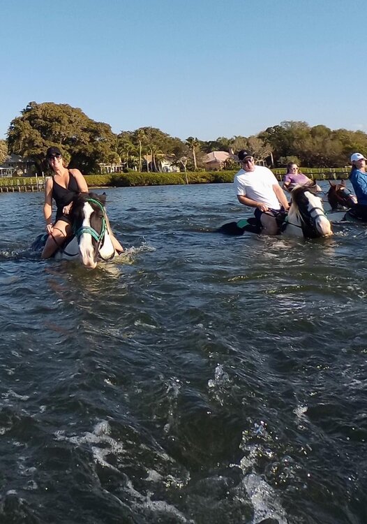
-
Mid to Long Range Discussion ~ 2022
Upstate Tiger replied to buckeyefan1's topic in Southeastern States
We may not see another area wide winter storm this season but the pattern over the next 2 weeks could very well produce a significant storm. This winter has defied many of the expectations from a typical Nina winter in the SE. It has certainly exceeded the last 2 winters in the SE. If we don’t get anything out of Mondays setup, there is another deep storm predicted to role over the Midwest at the end of next week that should drag a strong cold front south. This would be the next timeframe to watch. -
Mid to Long Range Discussion ~ 2022
Upstate Tiger replied to buckeyefan1's topic in Southeastern States
Nah. Sounds like Clemson football. Season started with great promise, every Monday I felt good about our chances, but each weekend just brought disappointment. -
30 and freezing rain in Cherryville this morning. Grass and trees covered in ice, broom straw bent over. Did not encounter any issues on my drive to Gastonia.
-
Mid to Long Range Discussion ~ 2022
Upstate Tiger replied to buckeyefan1's topic in Southeastern States
Still liking the set up for the period around the 12th - 14th. This overall set up has been pretty consistent on the GFS. Why not go for 5 weekends in a row with wintry weather in the SE? That would be rarity in my many years including the late 60's, 70's, and 80's. -
Potential 1/28-1/30 2022 winter storm
Upstate Tiger replied to Prismshine Productions's topic in Southeastern States
Light snow and 34 in Cherryville. 3rd weekend in a row with snow Imby -
Mid to Long Range Discussion ~ 2022
Upstate Tiger replied to buckeyefan1's topic in Southeastern States
Trying to remember a time in my 46 years of SE winter watching that true arctic air was in place before we had a winter storm. The only 1 event I recall where arctic air arrived 48 hours before the event (single digit lows and highs in 20's) was 1/13/82 storm. Two other events I recall where arctic air arrived 24 before the storm was the great President's Day storm of 79 and the big overrunning storm of 1/7/1988. Point well taken that with true arctic outbreaks in the SE, we generally need the cold air arrival to coincide with the low pressure development. I might add that I have seen arctic air arrive at the same time as a storm such Jan 87 and March 80 where temps fell into the middle teens during the storm. -
Potential 1/28-1/30 2022 winter storm
Upstate Tiger replied to Prismshine Productions's topic in Southeastern States
The GSP AFD link is broken. What did you guys do????? -
Potential 1/28-1/30 2022 winter storm
Upstate Tiger replied to Prismshine Productions's topic in Southeastern States

-
Mid to Long Range Discussion ~ 2022
Upstate Tiger replied to buckeyefan1's topic in Southeastern States
Burrel, was about to post the same thing. Ridge looks to build back after 1st week of February with cold still in Canada. It will have to come south and east. Something tells me we haven't seen the last of winter 22. On a positive note, maybe I can a round of golf in now. It's been about 3 weeks since I have been able to play. -
Potential 1/28-1/30 2022 winter storm
Upstate Tiger replied to Prismshine Productions's topic in Southeastern States
Agree. The 06 had another winter storm next weekend in the SE. -
29 and light snow in Cherryville. Happy for all the board members in central and eastern NC and SC who look to cash in tonight. Maybe a week from tonight we all can cash in!!!
-
Mid to Long Range Discussion ~ 2022
Upstate Tiger replied to buckeyefan1's topic in Southeastern States
Euro 12Z for next Friday.
-
Mid to Long Range Discussion ~ 2022
Upstate Tiger replied to buckeyefan1's topic in Southeastern States
Borderline Cat 3. -
Light rain mixed with snow here in Cherryville and 36 a few minutes ago. Now just light rain. Looks like the radar is really starting to blossom all the way back to the upstate. Has to bode well for those northeast of here.
-
Mid to Long Range Discussion ~ 2022
Upstate Tiger replied to buckeyefan1's topic in Southeastern States
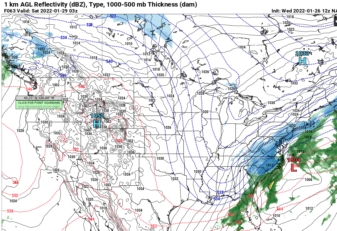
According to long term GFS, heights look to fall again in the west the first week of February so looks like we have another week to 10 days under the current pattern to score another storm in the SE before heights rise. With the unpredictability over the last couple of weeks, I don't think anyone can say with any degree of certainty what is going to happen over the next two weeks. Good news for winter lovers, is the cold remains across Canada in the long term poised to come south and east with with any height falls in the central and eastern U.S. -
Mid to Long Range Discussion ~ 2022
Upstate Tiger replied to buckeyefan1's topic in Southeastern States
No less than 4 chances for winter storms showing up on the GFS over the next 2 weeks starting next Wednesday. -
Mid to Long Range Discussion ~ 2022
Upstate Tiger replied to buckeyefan1's topic in Southeastern States
There will certainly be an abundance of cold air on this side of the continent over the next 10 days for anything that develops in the SE. https://mag.ncep.noaa.gov/model-guidance-model-parameter.php?group=Model Guidance&model=GFS&area=NAMER&ps=area# -
January 20-22 “bring the mojo” winter storm threat
Upstate Tiger replied to lilj4425's topic in Southeastern States
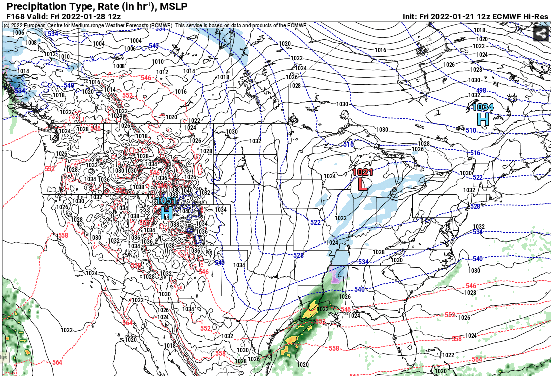
GSP still has wintery weather for the area Friday into Friday night. As of 215 pm EST Tuesday: The pattern will get active once again through the short-term period as a series of northern stream waves dive southeast through the Great Lakes region Wednesday night into Thursday and amplify a positively tilted trough from the Upper Midwest to the central Plains. The trough will help to drive a moist cold front into the southern Appalachians Wednesday night, which will slip southeast of the area through Thursday. Anticipate mainly liquid ptypes with the fropa, except at the higher peaks and increasingly along the Tennessee border in brief, post fropa northwest flow. Since the highest QPF over the western mountains should be one-half inch or less, this should not be sufficient for hydro issues to develop, even with some mountain snow melt. It has become questionable how much of a lull will develop between the cold fropa and redeveloping upglide over the stalling boundary. A consensus is building that a sharpening upper jetlet may develop along the southern Appalachians Thursday night through Friday. The amplifying upstream trough will be potent, but now appears less likely to cut off west of the Appalachians and more likely to get picked up by the northern stream. The main uncertainty during the Thursday night to Friday period is how vigorous any surface waves become along the stalled boundary draped to our southeast. The ECM has stronger development and pulls more moisture, and thereby QPF, over the region Friday, while the GFS has a more muted response. The ECMWF has trended slightly toward the GFS, but the GEFS ensembles have plenty of snowy members still. Will use an ensemble approach to profiles and keep mainly snow across the region, but with a snow, sleet, and freezing rain mention for the southeast third. This will be introduced into the HWO. Temps will be shaded below guidance as cold air damming develops Friday from 1040 mb high pressure over New England. The wintry precipitation will continue into the early extended period. -
January 20-22 “bring the mojo” winter storm threat
Upstate Tiger replied to lilj4425's topic in Southeastern States
Yep, Burrel that's a great summation. Seems we've seen energy get left in the SW often over the last decade. Euro will be very telling today. -
Winter Storm Izzy Obs Thread
Upstate Tiger replied to Prismshine Productions's topic in Southeastern States
Cherryville mostly sleet and has dropped to 23 with 10 degree wind chill.