

Upstate Tiger
-
Posts
703 -
Joined
-
Last visited
Content Type
Profiles
Blogs
Forums
American Weather
Media Demo
Store
Gallery
Everything posted by Upstate Tiger
-

Mid to Long Range Discussion ~ 2022
Upstate Tiger replied to buckeyefan1's topic in Southeastern States
Very well could be right but everybody was saying the same thing last January leading up to that storm and the GFS lead the way. -
Mid to Long Range Discussion ~ 2022
Upstate Tiger replied to buckeyefan1's topic in Southeastern States
Not sure either. Looked good to me -
Mid to Long Range Discussion ~ 2022
Upstate Tiger replied to buckeyefan1's topic in Southeastern States
Man the Euro is bringing in the cold starting this weekend with another big dump Christmas weekend. If we can get just a little bit of blocking over the next 2 weeks we could see a nice winter storm in SE. Speaking of cold, does it ever feel any colder than when it is raining and 39 degrees like today? -
Mid to Long Range Discussion ~ 2022
Upstate Tiger replied to buckeyefan1's topic in Southeastern States
CPC out this afternoon sticking with potential of a Miller A around Christmas. https://www.cpc.ncep.noaa.gov/products/predictions/threats/threats.php -
Mid to Long Range Discussion ~ 2022
Upstate Tiger replied to buckeyefan1's topic in Southeastern States
Agree also. I do not see anything in the Ops or Ens from overnight that should cause any cliff diving. We have seen far worse patterns this time of the year in recent years. -
Mid to Long Range Discussion ~ 2022
Upstate Tiger replied to buckeyefan1's topic in Southeastern States
Glad to see the rain but what a crappy run of weather. Must be what it's like to live in London. Gloomy, damp, and cold. Hopefully we see some sun next week. This could make a person depressed! -
Mid to Long Range Discussion ~ 2022
Upstate Tiger replied to buckeyefan1's topic in Southeastern States
CPC yesterday versus today https://www.cpc.ncep.noaa.gov/products/precip/CWlink/pna/pna.shtml -
Mid to Long Range Discussion ~ 2022
Upstate Tiger replied to buckeyefan1's topic in Southeastern States
As mentioned above, the change from yesterday's forecast in the PNA is the difference. Yesterday's PNA forecast has it moving to positive between the 10-15th. Today it keeps it negative. -
Mid to Long Range Discussion ~ 2022
Upstate Tiger replied to buckeyefan1's topic in Southeastern States
Good synopsis of the pattern in week two from the CPC. Basically agreeing with previous comments posted above: https://www.cpc.ncep.noaa.gov/products/predictions/threats/threats.php -
Mid to Long Range Discussion ~ 2022
Upstate Tiger replied to buckeyefan1's topic in Southeastern States
As other have posted the pattern looks really good around mid-month looking at the latest GFS. Also, NAO heading to really negative territory while the PNA moves toward positive. -
Very, very sad news today from Charlotte. This happened not too far from our hospital. Jason seemed like a great guy. https://www.wbtv.com/2022/11/22/wbtv-mourning-loss-meteorologist-jason-myers-pilot-chip-tayag/
-
Mid to Long Range Discussion ~ 2022
Upstate Tiger replied to buckeyefan1's topic in Southeastern States
NAO looking to go negative first week of December. Hopefully PNA continues to trend in a positive direction. https://www.cpc.ncep.noaa.gov/products/precip/CWlink/pna/nao_index_mrf.shtml -
Mid to Long Range Discussion ~ 2022
Upstate Tiger replied to buckeyefan1's topic in Southeastern States
Looks like flow is less amplified after next weekend but wow there is some really cold air building again in central and western Canada the last week of November. https://mag.ncep.noaa.gov/model-guidance-model-parameter.php?group=Model Guidance&model=GFS&area=NAMER&ps=area# -
Mid to Long Range Discussion ~ 2022
Upstate Tiger replied to buckeyefan1's topic in Southeastern States
I keep looking for some hint of some cold coming south through the middle of the month but nothing showing up. There will be some record breaking cold out west next week, especially across the northern Rockies and northern Great Plans. Lower heights out west should relax after next week. NAO looks to stay positive through the middle of the month. After below normal November's for the last few years, maybe we get a below normal December and January instead! -
Mid to Long Range Discussion ~ 2022
Upstate Tiger replied to buckeyefan1's topic in Southeastern States
At the end of the 12Z GFS, first week of November, looks like some good cold building in central and western Canada. -
Winter 2022-2023 Outlook Discussion
Upstate Tiger replied to WinstonSalemArlington's topic in Southeastern States
This combined with the data shared today on pre 1990 October freezes is pretty eye opening. Depending on perspective, one could assume a change is inevitable. I’m going to enjoy this awesome stretch of fall weather and hope for a good winter storm or 2. -
Was thinking that remaining in the mid 50s all day in Cherryville probably breaks the September lowest maximum of all time or has to be near the top.
-
Never mind, found it. 963 at 1100 advisory.
-
Does anyone know where you can find the latest central pressure? I have looked on the NHC Ian site and the 1100 update as well as weather channel but can't find one since 0800.
-
My Wolfpack friends might want to pack the rain gear for Saturday night. Probably not a good tailgating game. Shame with Gameday in town and national TV for top 10 matchup. Looks really nasty.
-
Mid to Long Range Discussion ~ 2022
Upstate Tiger replied to buckeyefan1's topic in Southeastern States
See some lows in the 50s showing up in the long range for the Piedmont. -
Mid to Long Range Discussion ~ 2022
Upstate Tiger replied to buckeyefan1's topic in Southeastern States
We had our 14th foggy morning in the month of August here in Cherryville. In anticipation of all the snow we are going to get this winter, I ordered this bad boy off Craig's List. A little ol lady in Jamaica had it for sale. She said it was barely used. Can't wait for it to get here. I will let you guys know how it works when we get our first snow in October.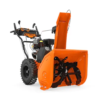
-
Mid to Long Range Discussion ~ 2022
Upstate Tiger replied to buckeyefan1's topic in Southeastern States
Pretty good early write up on upcoming winter. Seems reasonable to me if La Nina wains... https://www.wlfi.com/news/august-9-fall-winter-spring-2022-23-forecast-with-sneak-peek-regarding-thoughts-on-2023/article_93b83b22-1809-11ed-a2e6-0b4ed9cf3229.html -
Mid to Long Range Discussion ~ 2022
Upstate Tiger replied to buckeyefan1's topic in Southeastern States
Loving this pattern! Sometimes we get locked into these almost monsoon like August patterns in the SE. Rare, but looks like this may be one of those Augusts. Remember August of 1978 as one such August. On another note, looking like ENSO moves from La Nina to neutral in January. How quickly, if it happens at all, and its impacts on our winter weather prospects can't be known at this point. However, I'm thrilled to be moving out of La Nina! (allegedly ) https://www.cpc.ncep.noaa.gov/products/analysis_monitoring/enso_advisory/ensodisc.shtml -
Mid to Long Range Discussion ~ 2022
Upstate Tiger replied to buckeyefan1's topic in Southeastern States
Everything I am reading states that La Nina will continue into the fall and early winter months. Not great news for winter storm lovers in the SE. More importantly, we do not need another dry winter/spring. There are some indications that it breaks after December. We shall see. https://www.severe-weather.eu/long-range-2/fall-season-2022-early-weather-forecast-united-states-europe-fa/


