

Upstate Tiger
-
Posts
703 -
Joined
-
Last visited
Content Type
Profiles
Blogs
Forums
American Weather
Media Demo
Store
Gallery
Everything posted by Upstate Tiger
-

Mid to Long Range Discussion ~ 2023
Upstate Tiger replied to buckeyefan1's topic in Southeastern States
It’s never right at this range with a winter storm but watch it be right with a cat 4 hurricane. -
Mid to Long Range Discussion ~ 2023
Upstate Tiger replied to buckeyefan1's topic in Southeastern States
Of course it’s a historic anomaly. I’ll be at Myrtle Beach Saturday - Wednesday. -
Good analysis on Tennessee upcoming winter forum for those interested.
-
In Myrtle Beach on 6th floor of hotel. Storms right on our doorstep. Winds are making a creepy howling sound. Told the wife I can’t imagine what the wind would sound like in here in a hurricane.
-
Mid to Long Range Discussion ~ 2023
Upstate Tiger replied to buckeyefan1's topic in Southeastern States
Hope he's right Cary. BTW, just saw the other thread on 23/24 winter predictions... -
Mid to Long Range Discussion ~ 2023
Upstate Tiger replied to buckeyefan1's topic in Southeastern States
While we deal with this ongoing hot pattern...latest ENSO predictions increase chance for moderate to strong El Nino. 97/98 and 15/16 are analogs. Neither were stellar years in the SE FWIW but it only takes one! The most recent IRI plume indicates El Niño will persist through the Northern Hemisphere winter 2023-24 [Fig. 6]. Forecasters favor continued growth of El Niño through the fall, peaking this winter with moderate-to-strong intensity (81% chance of November-January Niño-3.4 ≥ 1.0°C). An event that becomes "historically strong" (seasonally averaged Niño-3.4 ≥ 2.0°C), rivaling the winters of 1997-98 or 2015-16, has an approximately 1 in 5 chance. In summary, there is a greater than 90% chance that El Niño will continue through the Northern Hemisphere winter [Fig. 7]. https://www.cpc.ncep.noaa.gov/products/analysis_monitoring/enso_advisory/ensodisc.shtml -
2023 Mountains Spring/Summer Thread
Upstate Tiger replied to Tyler Penland's topic in Southeastern States
Yeah, we were under it. About 3.5 hours moderate to heavy rain. Lost power for 2.5 hours. Not complaining. We were very dry. -
Mid to Long Range Discussion ~ 2023
Upstate Tiger replied to buckeyefan1's topic in Southeastern States
Figures. Was supposed to play in a golf tournament tomorrow lol. Can't complain too much. We finally had a nice weekend. -
Mid to Long Range Discussion ~ 2023
Upstate Tiger replied to buckeyefan1's topic in Southeastern States
Yep. I love the 76-80 weak nino! 4 straight epic winters from my youth! I believe that was a also a predominantly negative NAO. -
Mid to Long Range Discussion ~ 2023
Upstate Tiger replied to buckeyefan1's topic in Southeastern States
Looking ahead to fall and winter. Odds are increasing of a moderate to strong El Nino in the late fall and winter. Climatologically, not great for SE snow but has to be better than 3 years of Nina. I have posted the strong to moderate El Nino years below. There are some winners in the there for major storms... https://www.cpc.ncep.noaa.gov/products/analysis_monitoring/lanina/enso_evolution-status-fcsts-web.pdf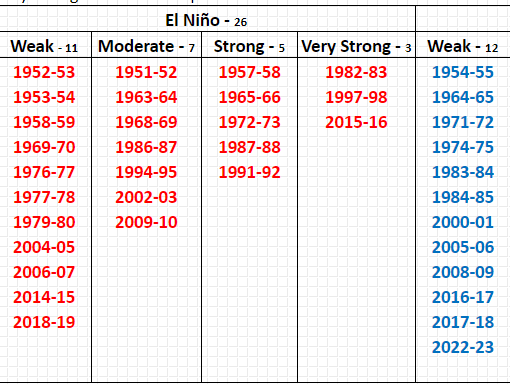
-
Mid to Long Range Discussion ~ 2023
Upstate Tiger replied to buckeyefan1's topic in Southeastern States
From KGSP AM AFD...can we ever get a flippin weekend with no rain? "Have higher chance PoPs the rest of the long term as guidance is generally trending wetter this weekend into early next week." -
Mid to Long Range Discussion ~ 2023
Upstate Tiger replied to buckeyefan1's topic in Southeastern States
BTW. The average global temp was down 1 degree. -
Mid to Long Range Discussion ~ 2023
Upstate Tiger replied to buckeyefan1's topic in Southeastern States
Most failed. Led to widespread food shortages in America and Europe. -
Mid to Long Range Discussion ~ 2023
Upstate Tiger replied to buckeyefan1's topic in Southeastern States
Reading some stuff this morning about 1816, the year without summer. Our current pattern is in no way similar to that global event brought on largely by the eruption of Mt Tambora. Nevertheless, fascinating reading. The New England states had frost every month that year and widespread snow in June. Philadelphia had frost on the 4th of July and Augusta Ga had a low of 43. Several other crazy anomalies that summer that are worth checking out. -
52 this morning in Cherryville. Unreal. Not complaining though!
-
Mid to Long Range Discussion ~ 2023
Upstate Tiger replied to buckeyefan1's topic in Southeastern States
Highs Saturday and Sunday may not get out of the low 50's. That would be 30 degrees below average and easily set records for low maximums. The pool is opening this weekend at the country club. Think we'll hold off a week. Probably won't be difficult to get chairs though... -
53 this morning in Cherryville. Very refreshing.
-
Mid to Long Range Discussion ~ 2023
Upstate Tiger replied to buckeyefan1's topic in Southeastern States
Would have been really interesting to have seen this weekend's setup in January or February. https://forecast.weather.gov/product.php?site=NWS&issuedby=GSP&product=AFD&format=ci&version=1&glossary=1&highlight=off -
39 this morning in Cherryville. Has felt like fall last several days. Hard to believe July 4 is 8 weeks away.
-
Mid to Long Range Discussion ~ 2023
Upstate Tiger replied to buckeyefan1's topic in Southeastern States
What a nice Easter weekend in store for us in the Carolinas... LONG TERM /THURSDAY THROUGH SUNDAY/... As of 300 AM EDT Monday: The alluded frontal boundary will sweep into the CFWA on Thursday. Most model guidance keeps a narrow band of showers and storms along the boundary as it pushes through the area. Some scattered showers and storms may develop just ahead of the main boundary, but the main focus will be along the frontal axis. With a slight uptick in shear parameters and global models/NAM depicting decent SBCAPE (750-1500 J/kg) values ahead of the boundary, most should expect some form of organized convection Thursday afternoon/evening, with a low-end severe threat, but confidence remains low on this development. Either way, temperatures will remain 10-15 degrees above-normal for highs on Thursday as most of the CFWA will settle under a stout warm sector. Major changes will be underway behind the front Thursday night as a strong surface high travels across the Central Plains and Midwest Thursday and into the OH Valley Thursday night. As the surface high sets up shop over the Mid-Atlantic early Friday, model guidance continue to place the CFWA under a hybrid CAD. With the flow aloft oriented from the southwest to northeast, deep moisture will continue to traverse over the CAD dome. Expect temperatures to dropoff nearly 20 degrees for highs on Friday compared to Thursday. The frontal boundary will stall south of the area, but moist upglide should keep PoPs elevated on Friday and through much of the weekend. By the weekend, the surface high should slip offshore the Mid-Atlantic coast and transition into more of an in-situ wedge, locking in the cold air through at least Sunday with temperatures remaining 10-15 degrees below-normal over the weekend for highs, with the potential for values to be even lower. Signs of CAD erosion doesn`t appear in model guidance until late Sunday into Monday as a shortwave trough pushes in from the Deep South and a surface wave travels underneath before deepening off the Southeast Coast during this timeframe. In this case, expect for a very cloudy and gloomy end to the week with well below-normal temperatures and continuous cloud cover through the end of the period following the fropa late Thursday. -
Mid to Long Range Discussion ~ 2023
Upstate Tiger replied to buckeyefan1's topic in Southeastern States
As has been previously mentioned, looks like a transition to El Nino by middle or end of summer. Would much prefer neutral enso as we head into fall but will gladly say goodbye to Nina! https://www.cpc.ncep.noaa.gov/products/analysis_monitoring/lanina/enso_evolution-status-fcsts-web.pdf -
Mid to Long Range Discussion ~ 2023
Upstate Tiger replied to buckeyefan1's topic in Southeastern States
Someone reminded me today that it was the anniversary of the March 28, 1984 Carolinas Tornado outbreak. I was on the 4th floor of a dorm room in Rock Hill. The thing I remember distinctly about that day was coming out of class in the afternoon and it was so hot and humid I could hardly breath. It was one of the worst outbreaks ever in this region. https://www.weather.gov/mhx/Mar281984EventReview -
Mid to Long Range Discussion ~ 2023
Upstate Tiger replied to buckeyefan1's topic in Southeastern States
Cold springs have become the norm over the last few years and this year looks no different. Silver lining is it keeps the bugs and humidity at bay a little longer but the fairways take longer to turn green and pool stays cold until the end of June. -
Mid to Long Range Discussion ~ 2023
Upstate Tiger replied to buckeyefan1's topic in Southeastern States
4 mornings in the past week 25 degrees or lower including two 23 degree readings. Pretty impressive for late March. Also, killed my Azaleas! -
Mid to Long Range Discussion ~ 2023
Upstate Tiger replied to buckeyefan1's topic in Southeastern States
What's wrong with the Euro? Winnies have it clogged up?


