

Upstate Tiger
-
Posts
984 -
Joined
-
Last visited
About Upstate Tiger

Recent Profile Visitors
7,620 profile views


-

Winter 2026-2027 Seasonal Outlook
Upstate Tiger replied to WinstonSalemArlington's topic in Southeastern States
From Glenn Burns. I know it is the middle of summer, however there are some clear signals already being seen about our upcoming winter. Early signs are emerging for more Polar Vortex disruptions. New long-range data shows a notable January weakening signal in the stratosphere. We have a Super El Nino changing global wind and weather patterns. Another MAJOR contributor is the melting arctic sea ice. The arctic is warming 4 times faster than the rest of the planet! Just look at the difference in sea ice from just 10 years ago. A 40% loss! With more exposed ocean we have more heat being absorbed. That heat is a major contributor to disruptions and weakening of the polar vortex, sending frigid arctic air south. With a Super El Nino providing a lot of moisture in the southeast, things could get very interesting this winter, especially late winter. A weaker or disrupted Polar Vortex does not guarantee cold and snow for everyone. But it does increase the chance that Arctic air can break out of the polar regions and reach us. Looking at the past three "Super" El Niño events—1982–1983, 1997–1998, and 2015–2016—the overarching theme for North Georgia was abundant moisture and a supercharged southern storm track. Because a strong El Niño parks the subtropical jet stream directly over the Southeast, a steady conveyor belt of Gulf moisture is virtually guaranteed. However, the temperature profiles and wintry outcomes varied drastically based on whether cold Arctic air was available to interact with that moisture. Here is how those three distinct winters played out across North Georgia: 1982–1983: The Frozen and Wet Super El Niño This event brought the classic combination of heavy precipitation and enough cold air to deliver significant winter weather. The Setup: The active southern storm track consistently collided with suppressed, cold air masses. The Weather: It was a chilly, highly active winter. Instead of just plain rain, North Georgia saw multiple wintry mix setups. Notable Outcomes: Atlanta recorded an impressive 10.3 inches of snow over the course of the 1982–1983 season. The active jet stream also spawned a severe coastal-tracking storm system in February 1983 that dumped massive snow further up the East Coast after clearing the Southeast. 1997–1998: The Warm, Soggier "Godzilla" El Niño The 1997–1998 event was one of the strongest ocean-warming anomalies on record, but a distinct lack of Arctic air kept North Georgia mostly out of the snow zones. The Setup: While the subtropical jet stream was incredibly intense and brought storm after storm, the polar jet stayed far to the north, locking the true winter cold up in Canada. The Weather: It was a cloudy, exceptionally wet, and generally mild winter. December saw near-normal temperatures, but January and February turned remarkably warm. Notable Outcomes: Instead of snow, this winter was defined by endless rain, mud, low solar days, and localized flooding. Wintry precipitation was remarkably rare across the region despite the endless moisture. 2015–2016: The Record-Breaking Warm and Flooded Winter This most recent Super El Niño shared many traits with 1997–1998, pushing the warm and wet side of the spectrum to historic extremes, particularly early in the season. The Setup: A dominant high-pressure ridge and a strong polar vortex kept cold air bottled up north, while a moisture-rich southerly flow relentlessly pumped air from the Gulf of Mexico. The Weather: December 2015 shattered records as the warmest and wettest on record for almost all of Georgia. Atlanta averaged a staggering 12.3°F above normal for the month, with high temperatures frequently climbing into the 70s. Notable Outcomes: Atlanta recorded 12.51 inches of rain in December alone (more than 8.5 inches above normal), leading to widespread river flooding and soggy soils. January and February finally cooled down closer to long-term averages, but the winter as a whole remained overwhelmingly warm, wet, and liquid. If you look at the baseline of a Super El Niño for North Georgia, you can safely bet on well above-average precipitation and active storm tracks. But as these three events show, the difference between a historic 10-inch snow season and a winter where people are wearing shorts on Christmas boils entirely to the wild card of the northern polar jet. That is why these early signals along the melting arctic sea ice gives us a better handle on what we might expect -
Winter 2026-2027 Seasonal Outlook
Upstate Tiger replied to WinstonSalemArlington's topic in Southeastern States
Good stuff! Thanks for researching. I was a senior in HS in 82/83. December was mild as I recall after a cool November. We had a small event of about 3” in early January from a Miller A. Another 3” event later in the month. Then we had the record breaker in March. So it was snowy winter in the upstate. The 1877/1878 is interesting. It is known as the Year Without Winter in the US. But your temp records seem to indicate a lot of BN in SE. This would align climatically with a Nino in the SE. I’m excited to see what is in store this winter! -
Winter 2026-2027 Seasonal Outlook
Upstate Tiger replied to WinstonSalemArlington's topic in Southeastern States
Not familiar with the author but interesting reading on a hot summer day regarding increased potential for positive PNA this winter and some of the data and science behind this potential pattern. https://www.severe-weather.eu/long-range-2/atlantic-anomaly-and-super-el-nino-shaping-early-winter-2026-2027-predictions-united-states-canada-europe-fa/ -
The notes say it was an unusually mild day for July.
-
A far cry from July 4, 1776. Weather report from the pen of Thomas Jefferson. Guess he would have been in the NE Forum...
-
Winter 2026-2027 Seasonal Outlook
Upstate Tiger replied to WinstonSalemArlington's topic in Southeastern States
I would be thrilled to see us have a wet winter regardless of precipitation type. But odds for sustained cold or multiple winter storms seem stacked against us. It only takes one like in 1983. The problem is our cold source region tends be depleted of arctic air during a strong nino.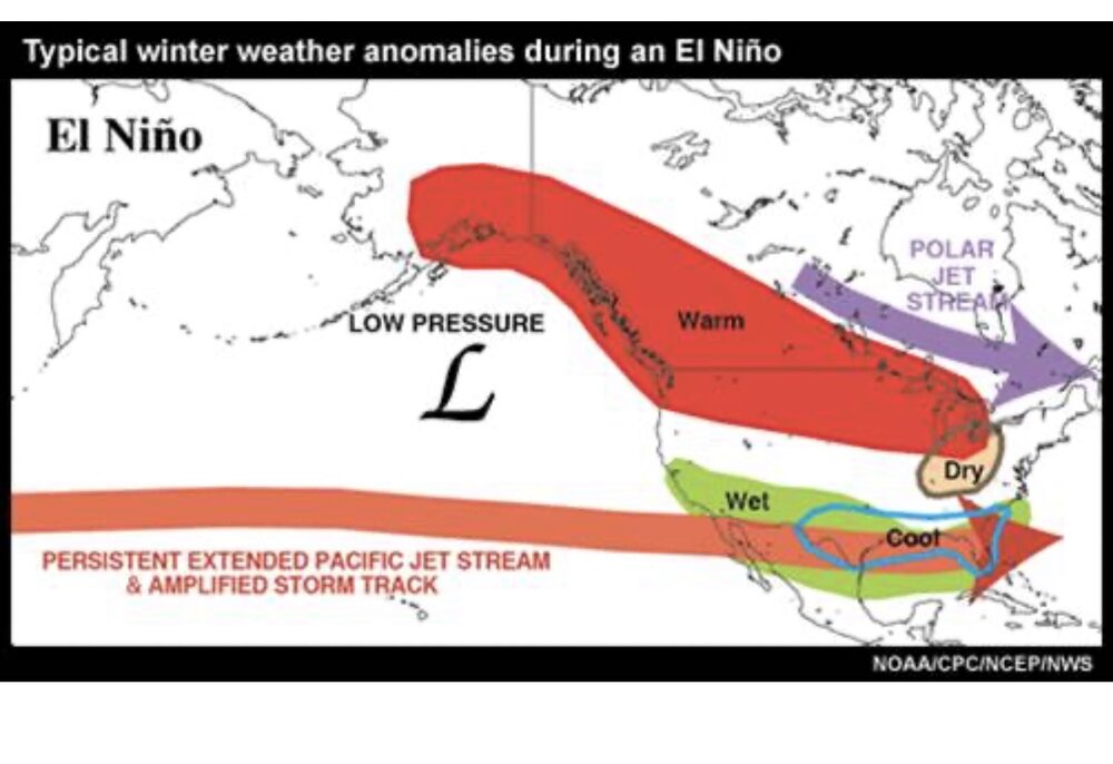
-
Glad for you all that are getting the rain! Much needed. We missed it by about 20 miles. Hopefully we get some tomorrow.
-
Winter 2026-2027 Seasonal Outlook
Upstate Tiger replied to WinstonSalemArlington's topic in Southeastern States
Hopefully not another 97/98 that was warm and had lots of severe weather including tornados. it only takes one cold air intrusion timed right to get a good winter storm. I would be surprised to see lots of below normal temps. -
Heard my first katydid this morning. Always reminds me of my grandmother. Like a lot of mountain people, she was always reciting folklore. One of them was that 16 weeks from the first katydid singing in the mountains of SC would be the first frost. It actually always works out pretty close…
-
Winter 2026-2027 Seasonal Outlook
Upstate Tiger replied to WinstonSalemArlington's topic in Southeastern States
So we have officially entered El Niño phase. Most agree it will be strong and possibly super El Niño. The strongest El Niño on record was the super El Niño of 1877/1878. It actually started in late 1876 and was fully established in spring 1877. The winter of 1877/1878 was known as the year without winter, especially in the Midwest and eastern US. Farmers actually planted in February. This El Niño is starting a little later and no two are the same but at this point, an above average temp winter would be a good bet. -
What an awesome day! Felt almost cool in the shade with the breeze. Probably the last day like this until September.
-
Wasn’t this the feature that nearly wrecked our 1/31 winter storm because it interrupted the gulf moisture transport?
-
Maybe we can get that back surgery dude to start the thread
-
My rain chances for tonight and tomorrow are falling like cheap lard. My yard is brown and crunchy.
-
Who would like to start the thread? On a more serious note, April 27 is the 15 year annivesary of the 2011 SE Super Outbreak....


