wxmeddler
-
Posts
6,558 -
Joined
-
Last visited
Content Type
Profiles
Blogs
Forums
American Weather
Media Demo
Store
Gallery
Everything posted by wxmeddler
-

2024 Valentines Day Who the Hell Knows - Comeback Thread
wxmeddler replied to DDweatherman's topic in Mid Atlantic
Interesting that the 12z Euro has a faster transition to negative tilt aloft. It's not as strong as the GFS but it's bending towards the GFS evolution. Still, relying on the cold conveyor belt for snow on a rapidly departing system is a bold move cotton. -
2024 Valentines Day Rain/Snow/Who The Hell Knows Thread
wxmeddler replied to WinterWxLuvr's topic in Mid Atlantic
There's no saving it with a further west neutral or even positive tilt system as it passes us. -
2024 Valentines Day Rain/Snow/Who The Hell Knows Thread
wxmeddler replied to WinterWxLuvr's topic in Mid Atlantic
I wanna know what the GFS is on, because it's good stuff whatever it is. It's got cooling 850 temps while warm air advection is happening. -
2024 Valentines Day Rain/Snow/Who The Hell Knows Thread
wxmeddler replied to WinterWxLuvr's topic in Mid Atlantic
Trend is definitely for a wetter system, but the trade off is that it goes negative tilt sooner, leading to a further west low. -
2024 Valentines Day Rain/Snow/Who The Hell Knows Thread
wxmeddler replied to WinterWxLuvr's topic in Mid Atlantic
If the GFS gets any more pinched off with the s/w we're just gonna get a bowling ball that runs too far south.. -
2024 Valentines Day Rain/Snow/Who The Hell Knows Thread
wxmeddler replied to WinterWxLuvr's topic in Mid Atlantic
I'm overall dubious about the cold air coming in hard from the E/NE late in the game as shown by the GFS. That might work if there was a modified arctic high sitting over Quebec, but there isn't here. -
Jan/Early Feb Medium/Long Range Discussion Part 3
wxmeddler replied to WinterWxLuvr's topic in Mid Atlantic
lol, didn't even have to look
-
Jan/Early Feb Medium/Long Range Discussion Part 3
wxmeddler replied to WinterWxLuvr's topic in Mid Atlantic
I can't wait till it comes north only for the CAD to be too dry and we get nothing before the WAA comes in and gives us rain. -
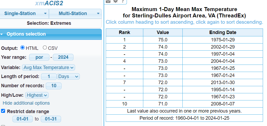
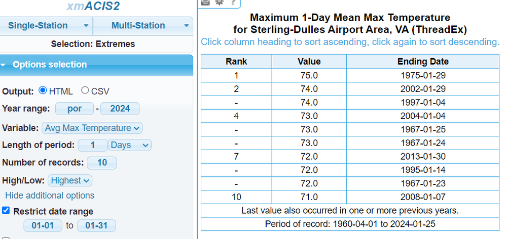
DC hit 77 that day.. Top 10: 1 79.0 1950-01-26 2 77.0 2002-01-30 - 77.0 1932-01-15 4 76.0 1975-01-29 - 76.0 1937-01-09 - 76.0 1932-01-14 - 76.0 1927-01-22 - 76.0 1907-01-07 - 76.0 1890-01-12 10 75.0 1975-01-11
-
No guidance had us getting into the upper 70's / flirting 80... We must really be mixing from up top.
-
Stafford AWOS has been on the fritz recently. Ignore.
-
Top 10 LWX/Dulles January Days
-
This former North Dakotan is DYING...
-
Favorite snow = convective snow with a big DGZ...
-
I'm gonna get the shaft between these 2 bands in Silver Spring. I can see the squall out my apartment window to the west by 2 miles.
-
Enjoy these last snow bands while you can... last heavy snow we're likely going to see until mid-Feb
-
By 21z our Sfc-700 lapse rates go up to about 6.5°/km and 7.5°/km from sfc-850. Those are excellent values for this region.
-
I see some measurements in the LSR's are measuring this event + the previous...
-
Jan 19th Snow on Snow: the this always works until it doesn't thread
wxmeddler replied to psuhoffman's topic in Mid Atlantic
Decent hit, inverted trough present at 700mb right through NE MD.. -
Jan 19th Snow on Snow: the this always works until it doesn't thread
wxmeddler replied to psuhoffman's topic in Mid Atlantic
So nice, Yoda posted it twice.. -
Clarksville MD Mesonet Station hit 2.1F... it's in a bit of a cold sink.
-
Jan 18-19 Storm Threat: Bob Chill made me do it
wxmeddler replied to stormtracker's topic in Mid Atlantic
Not worried. Euro Mean has had us at .2" liquid for awhile now. This will be a 1-3" and we'll be happy. Timing will be key though as we want the start before sunrise to get a base layer down.- 684 replies
-
- 10
-

-
Need winds to die down in order for the bottom to drop out..
-
Jan Medium/Long Range Disco 2: Total Obliteration is Coming
wxmeddler replied to Jebman's topic in Mid Atlantic
It's not like your name hasn't been plastered all over these boards since the days of Eastern...