wxmeddler
-
Posts
6,561 -
Joined
-
Last visited
Content Type
Profiles
Blogs
Forums
American Weather
Media Demo
Store
Gallery
Everything posted by wxmeddler
-
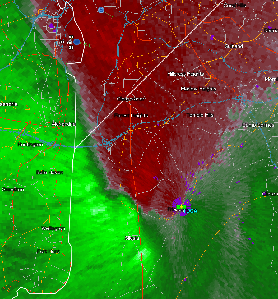
Tornado Warning for PG Co
-
Some silliness trying to happen south of Oxon Hill.
-
Thunder is very quality with the inversion.
-

January: Medium/ Long Range: May the Force be with Us....
wxmeddler replied to Weather Will's topic in Mid Atlantic
Well since the only thing it knows is history, its learned that we generally just get screwed. -
Light onshore flow from the bay will do that
-
My Prediction: Radar is gonna look worse than that surface. Even the 3KM NAM has dew pt depressions 7-10F in the AM. That said, it's gonna stick on roads that aren't treated.
-
Tiny bit of a shortwave at 500 moving through with some elevated moisture levels and clouds. Might put a pause on our cooling for a 3-4 hours. Still, longest night of the year. Someone is gonna get single digits east of the Blue Ridge.

-
Rates can overcome any ground temp. We just don't have the rates. Visibility hasn't dropped below a mile at DMW or FDK Edit: Which isn't surprising. Pretty abysmal thermodynamics going on.
-
Parr's Ridge is probably about the only place in the state that is accumulating right now..
-
Was snow when I left Silver Spring this morning, turned to rain as I went downhill into College Park. Very noticeable R/S line at ~300ft.
-
We work with local entities at every level. It's hard, but worth it. Wouldn't be possible without the crew we got going.
-
Snow TV achieved at 360' elevation in Silver Spring. Apparently still rain down in College Park (50').
-
As an FYI for everyone using this, the snow depth sensors are only accurate to about +/- half an inch. So use your common sense if it's just starting to stick and it says zero OR it says 0.3" and it's raining. We're working on better QA/QC to try and make those kinds of errors happen less often; but as we know, snow depth is about the hardest thing to measure accurately. In addtion, it's only measuring ONE point on the ground, it doesn't know the difference between a drift and a scour.
-
High water mark for me in this event is SnowTV down to the fall line, and at least an inch along Parr's Ridge.
-
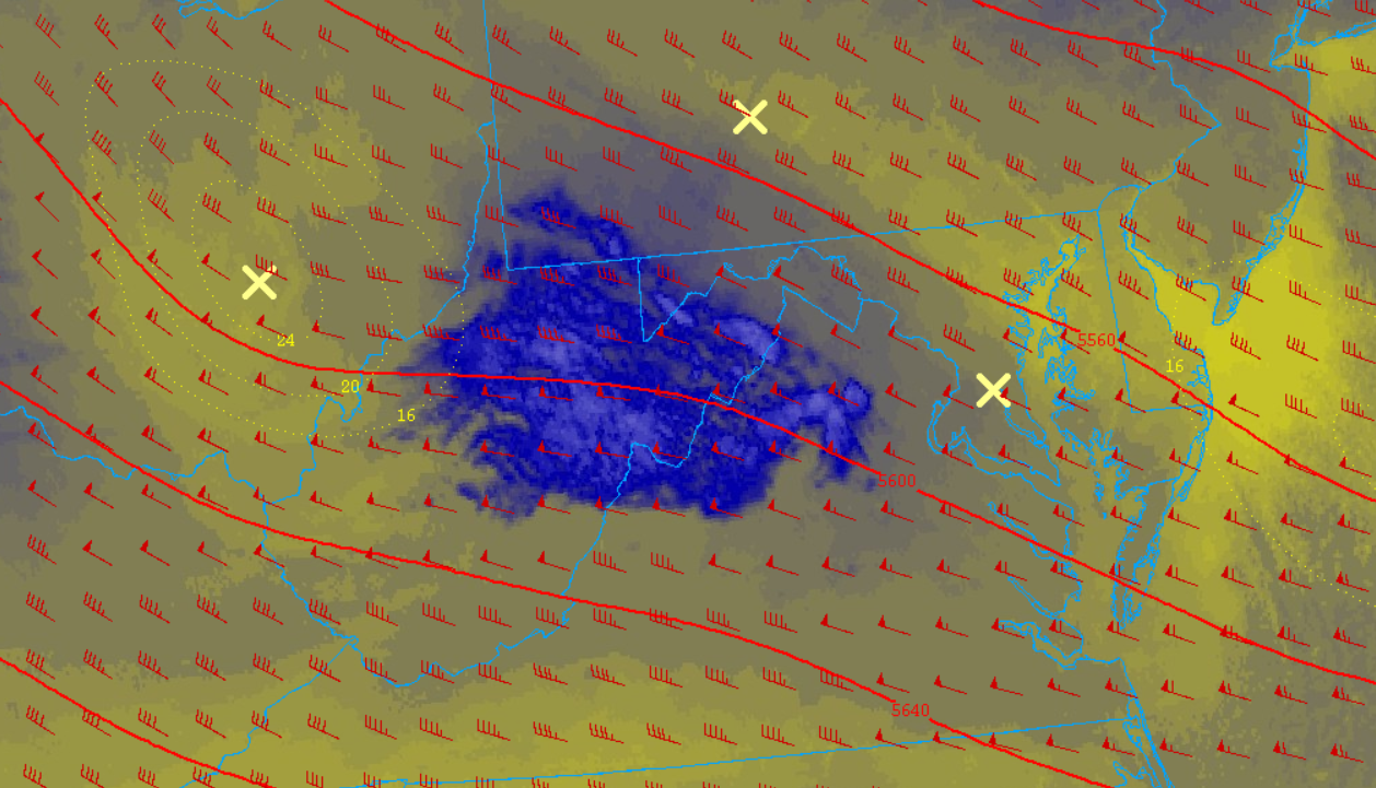
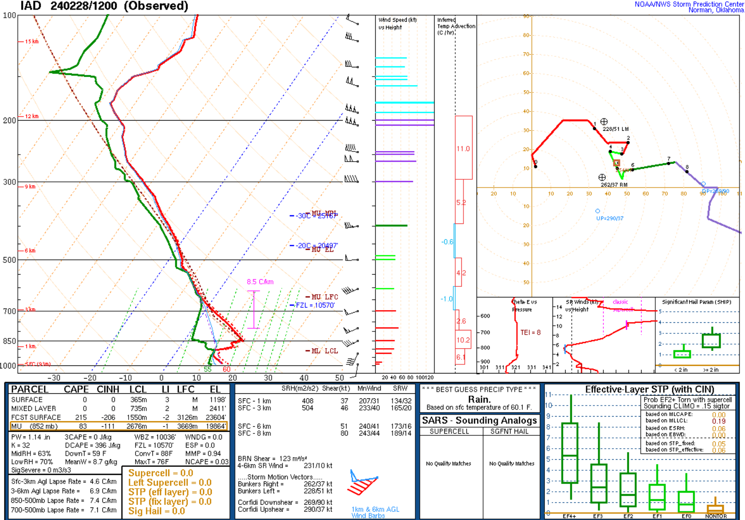
This morning's IAD EML, brought to you by... The Mexican High Plateau.
-
Weird that there is thunder... realtime guidance has no MUCAPE. lol
-
The Weekend Rule? Saturday 2/17 - The Icon Storm
wxmeddler replied to DDweatherman's topic in Mid Atlantic
Perfectly placed. Gonna "waste" about 45 min for it to move through.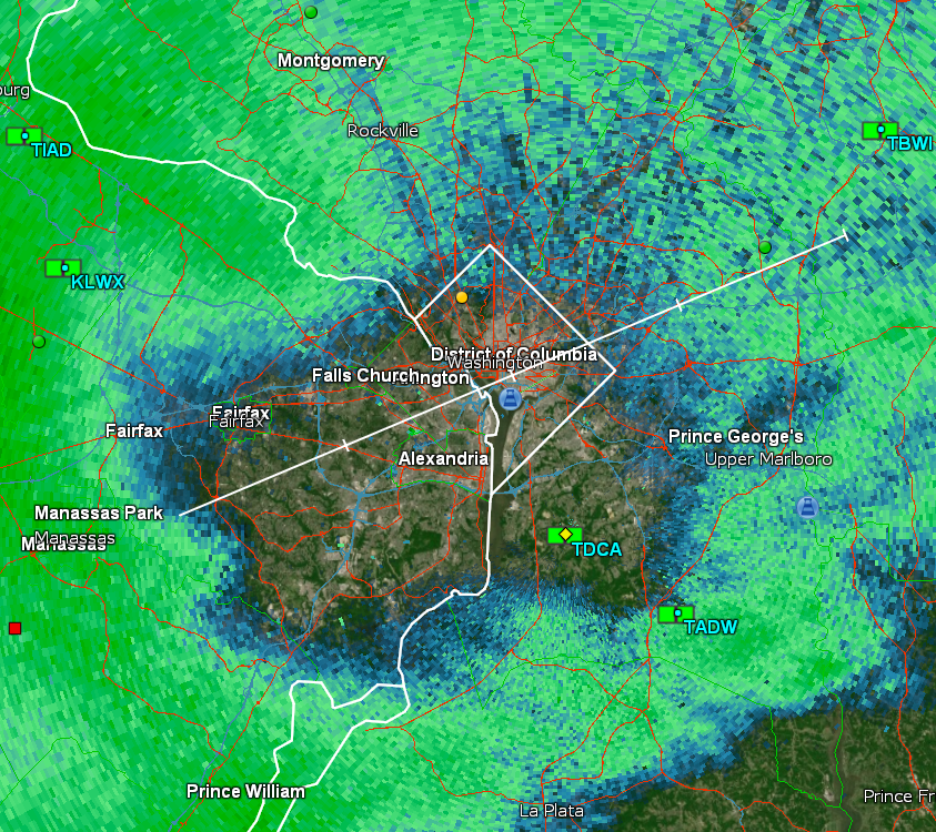
-
The Weekend Rule? Saturday 2/17 - The Icon Storm
wxmeddler replied to DDweatherman's topic in Mid Atlantic
Started as snow in Silver Spring. Pretty heavily sublimated though. Tiny flakes thus far. -
The Weekend Rule? Saturday 2/17 - The Icon Storm
wxmeddler replied to DDweatherman's topic in Mid Atlantic
12z GFS is bigger..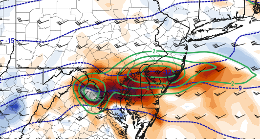
-
The Weekend Rule? Saturday 2/17 - The Icon Storm
wxmeddler replied to DDweatherman's topic in Mid Atlantic
There should be some good fluff to this, that's not a wet slop. -
The Weekend Rule? Saturday 2/17 - The Icon Storm
wxmeddler replied to DDweatherman's topic in Mid Atlantic
-
The Weekend Rule? Saturday 2/17 - The Icon Storm
wxmeddler replied to DDweatherman's topic in Mid Atlantic
Not sure what more you would want at this point with this wave. This is excellent, especially up near the Mason-Dixon, -12 at 700 overlapped with the best frontogenesis forcing is perfection.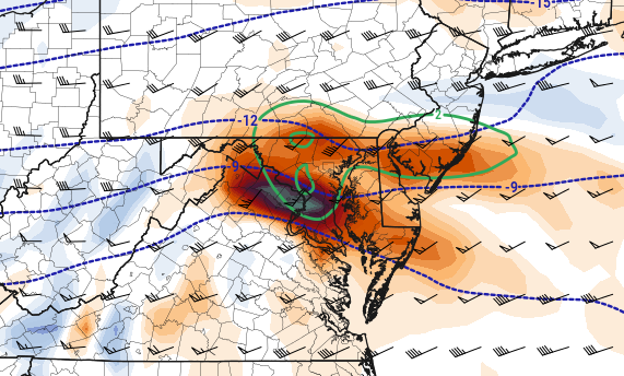
-
The Weekend Rule? Saturday 2/17 - The Icon Storm
wxmeddler replied to DDweatherman's topic in Mid Atlantic
Back in Fargo, we'd call this "another 2-4" event and everyone would shrug and go about their business. We're splitting hairs here at this point, this has been locked in for at least the last 36 hours. -
The Weekend Rule? Saturday 2/17 - The Icon Storm
wxmeddler replied to DDweatherman's topic in Mid Atlantic
Winds picked up with the FROPA and we're mixing out. -
The Weekend Rule? Saturday 2/17 - The Icon Storm
wxmeddler replied to DDweatherman's topic in Mid Atlantic