hawkeye_wx
-
Posts
6,260 -
Joined
-
Last visited
Content Type
Profiles
Blogs
Forums
American Weather
Media Demo
Store
Gallery
Everything posted by hawkeye_wx
-
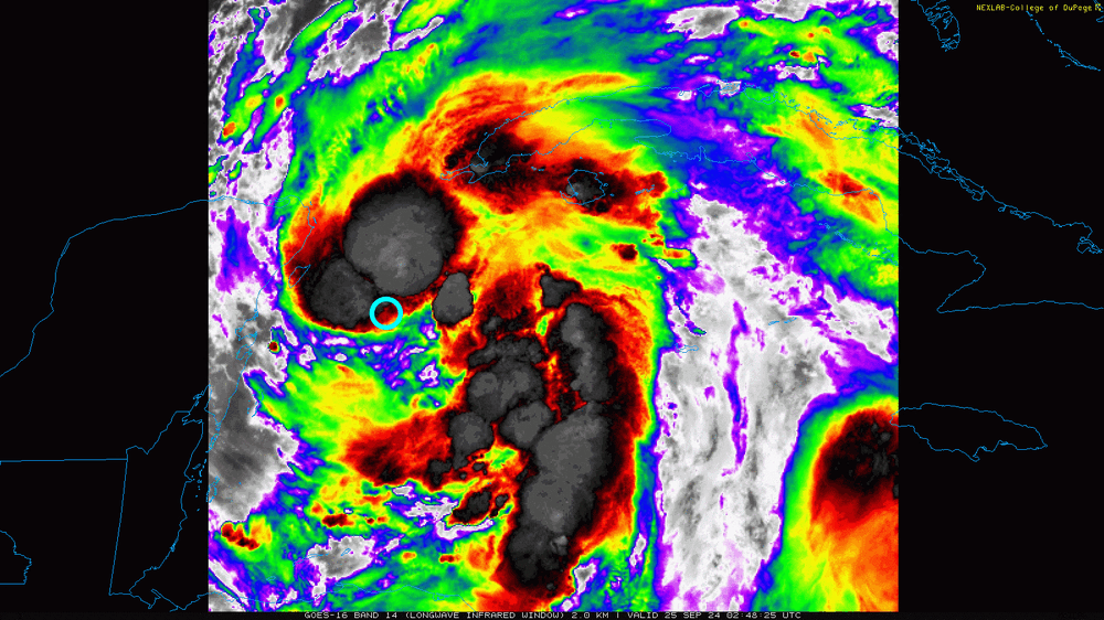
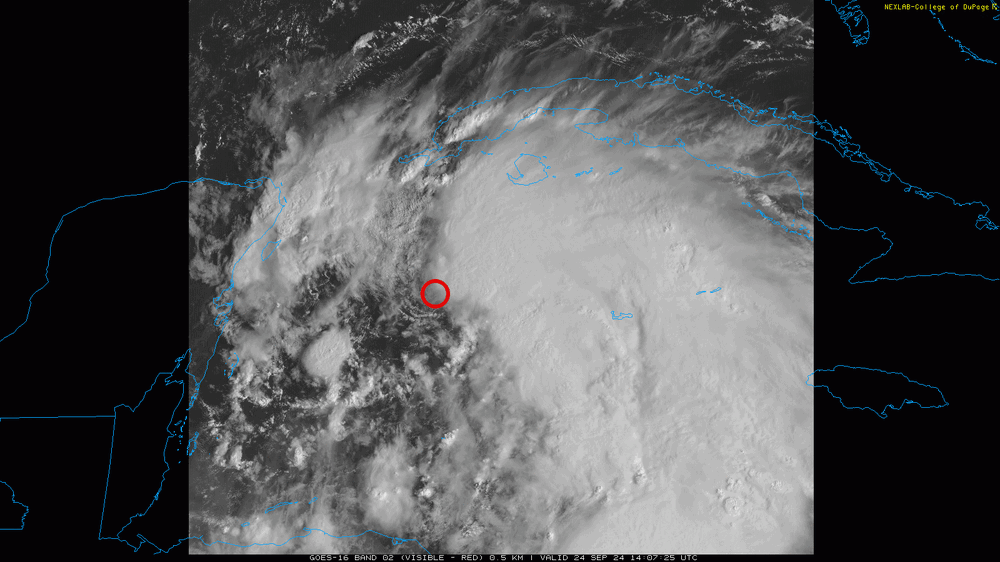
According to recon and satellite, the surface center is about where the blue circle is.
-
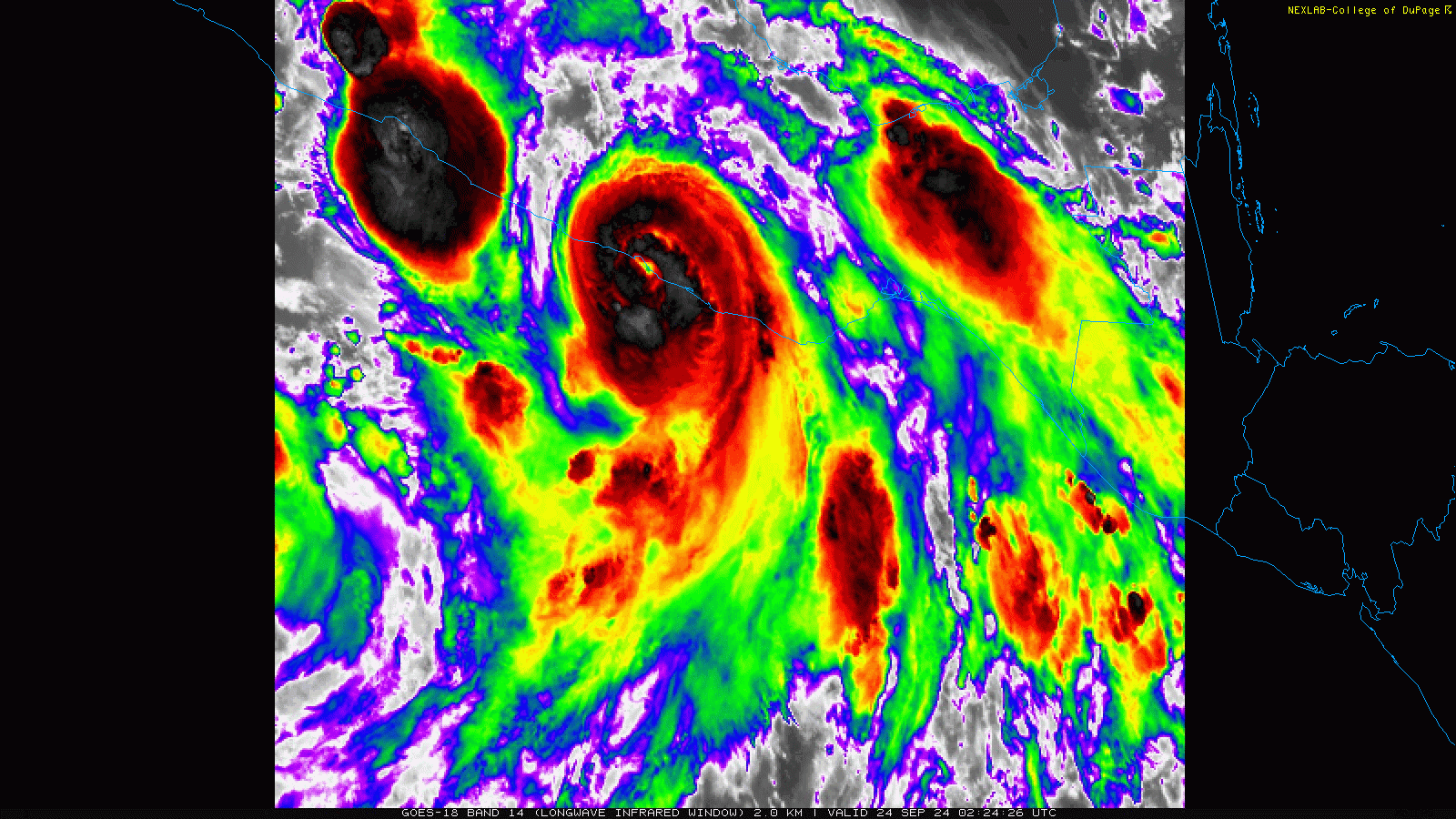
Recon is finding no wind anywhere close to hurricane force. Also, the surface center is still not even under the convection due to southerly shear.
-
The surface center is wobbling around a bit just south of the convection. Shear is certainly lower than this morning, but there is still enough to prevent the convection from wrapping over/around the center.
-
The newest recon pass actually found the center jogged a bit southwest since the last fix, so the surface center is not under that blob of convection, but just off the south edge. The dropsonde says 990 mb with 17 kt wind.
-
It appears the second recon plane, which took off from Biloxi a couple hours ago, encountered a problem while flying through the Yucatan Channel, so they had to end the flight and turn back.
-
Center dropsonde says 991 mb.
-
Ten minutes later, the buoy just dropped another full mb, to 992.9. The ball of convection over the center is doing some good work.
-
What's the deal with the GFS's depiction of Helene's vorticity, for the next two days, looking like a wobbly planet with a bunch of moons rotating around it? The other models all show one solid ball of vorticity.
-
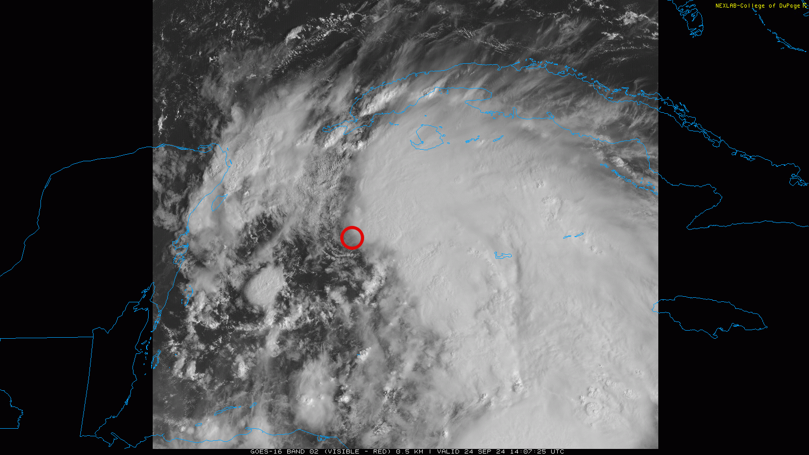
It appears a decent band of convection has begun to build just north and east of the surface center. The center is currently drifting nnw.
-
Helene currently has an interesting presentation. It has a well-defined center. There is convection up-shear and down-shear, but nothing near the center.
-
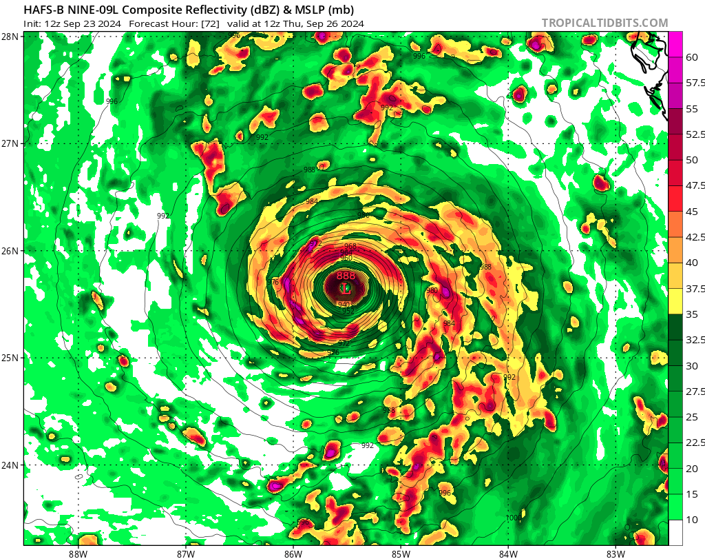
The HAFS models are both now much weaker over the eastern gulf, likely mostly due to Helene being de-cored over the Yucatan. A few hours over land is not a big deal, but twelve certainly is.
-
The 12z GFS shows several little pieces of vorticity pinwheeling around each other for the next couple days, which keeps Helene weak. It may be too weak.
-
The visible loop shows the surface circulation is becoming better defined. The center is right on the west edge of the convection. The recon extrap pressure is now creeping under 1000 mb.
-
The 06z Euro actually moves the center over the northeast tip of the Yucatan, where it only slowly moves for about 12 hours. Also, while the hurricane models insist on bombing it out over the eastern gulf, the Euro barely strengthens it at all.
-
The latest hurricane models are still bombing this thing over the loop current. What I don't understand is why these models continue to try to strengthen it so much today. I get that there is a disconnect when the system does not yet have a well-organized center, but why do these models seemingly not see the current shear?
-
I don't see much organization tonight. A blast of sw shear is preventing mid-level and surface alignment.
-
We have landfall. All the way up to landfall, the NHC never had John's forecast correct. It started as a TS tracking east, then transitioned to a cane moving northeast, then a major cane moving north. It ended up moving northwest.

-
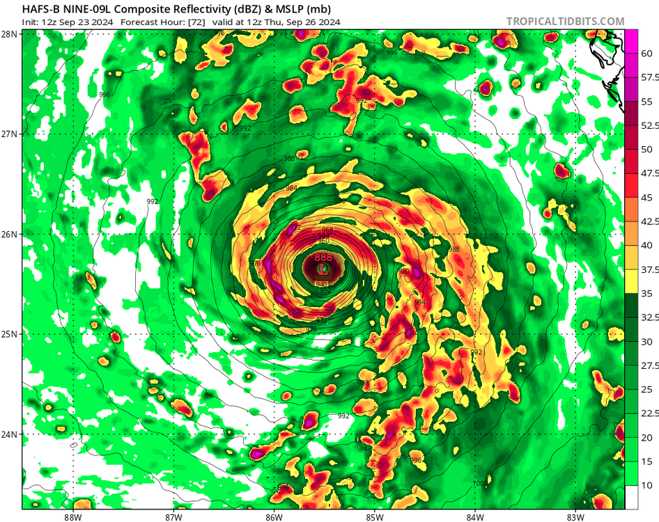
All of the hurricane models are much weaker at 18z because it takes a lot longer to organize. The HAFS-B is 90 mb weaker at 12z Thursday (888 mb to 978). The southerly shear in the nw Caribbean isn't going to help it organize.
-
The three recon passes found extrap pressure of 1008, 1006, and 1005 mb, so it's slowly dropping as the circulation develops.
-
All of the very-intense hurricane models have this system well-organized and deepening to 990 mb by 12z Tuesday. I'd say that is pretty unlikely.
-
Yeah, this isn't something we see every day. It's likely wildly overdone, but it's neat to look at.
-
The weak center of surface spin is currently located ssw of Grand Cayman, northwest of the convection.
-
It is likely the very intense hurricane models are organizing the system too quickly in the nw Caribbean. They are predicting a rapidly-strengthening hurricane before it even reaches the gulf. The Euro, on the other hand, has further-delayed the organization over the last two runs. It now has the system only slowly pulling the energy together over the next two days and reaching tropical storm status, 30+ mb weaker than the overzealous hurricane models at the Yucatan Channel.
-
The big weekend rain event was a massive bust for much of Iowa. I got 0.09". The airport got 0.00". It will likely be the driest September on record.
-
It's too hot and dry. Cedar Rapids hit 91º today, with full sun and no wind. Like Cyclone, we got no rain last night. The Sunday wave is fading on the models, so late Saturday is going to have to deliver.