hawkeye_wx
-
Posts
6,260 -
Joined
-
Last visited
Content Type
Profiles
Blogs
Forums
American Weather
Media Demo
Store
Gallery
Everything posted by hawkeye_wx
-
Cedar Rapids hit 60º. Des Moines hit 64º and Ames hit 65º.
-
Iowa is way over-performing today. A couple days ago it was supposed to be upper 40s here. This morning it was raised to the low 50s. It is currently 59º. Central Iowa is in the low 60s.
-

Fall/Winter '24 Banter and Complaints Go Here
hawkeye_wx replied to IWXwx's topic in Lakes/Ohio Valley
Zzzzzzzzzzzzzzzzzzz -
Winter 2024-25 Medium/Long Range Discussion
hawkeye_wx replied to michsnowfreak's topic in Lakes/Ohio Valley
The latest models have trended away from a good snow event. Instead, we get a fast zonal to nw flow that shears out any decent energy and suppresses moisture. This morning's Euro hardly has a sprinkle or flake here through ten days. -
November 2024 General Discussion
hawkeye_wx replied to SchaumburgStormer's topic in Lakes/Ohio Valley
I got 0.2" last night after dark when the temp fell below freezing. -
November 2024 General Discussion
hawkeye_wx replied to SchaumburgStormer's topic in Lakes/Ohio Valley
We are getting snow showers, but the flakes are tiny and it's too warm to accumulate. -
November 2024 General Discussion
hawkeye_wx replied to SchaumburgStormer's topic in Lakes/Ohio Valley
I received about 0.60" of rain from this system. It was a pretty big underperformer across the entire area. The model average was at least an inch. -
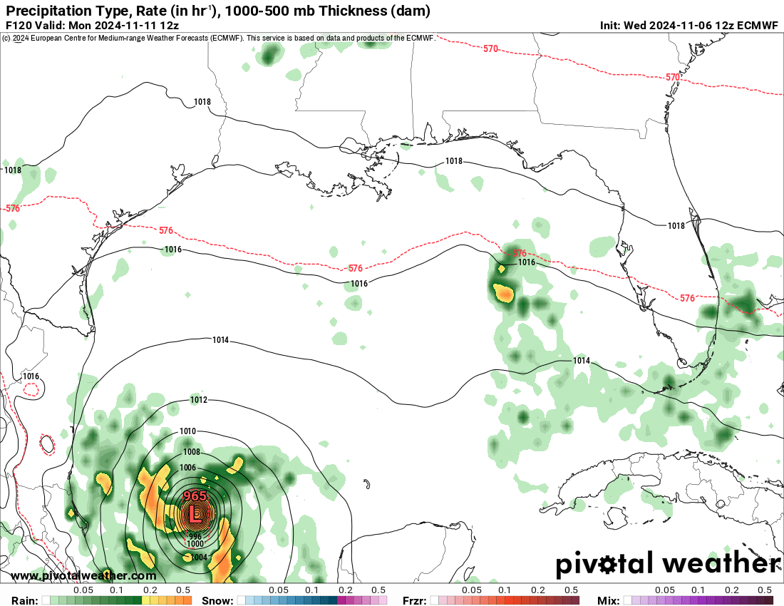
Tonight's ICON, UK, and Euro have all lost the strongly-digging second wave next week, which means no second storm or snow for Iowa. A second spin-up is delayed until much farther east.
-
I saw that the operational Euro got another upgrade a couple days ago. I didn't realize until today that range-extension was a part of it. The longer range for 06z and 18z is pretty nice. The 00z and 12z now going out to 15 days mostly just provides more fantasyland excitement, like the GFS. The day 8-10 maps are already low accuracy.
-
The Euro still brings this system back to life in the gulf after a long trek across the Yucatan. Florida gets a solid storm with rain and wind.
-
And now the Euro stalls this system on the Honduras coast and never develops it much. 24-48 hours ago this was looking pretty exciting to track, but it has come crashing down from that perspective.
-
This system is trending away from being a powerful hurricane over the open Caribbean and toward being a rain maker for Central America. The GFS has abandoned its earlier scenario of a quicker spin-up and stall (or even an eastward track) over the open water. The system is pretty broad and weak this morning, and south of earlier GFS runs. The ICON and AI Euro are showing a scrape of Honduras followed by Sara getting buried deep in the Yucatan.
-
The model trend is toward a farther west track. The non-GFS models had already trended to a track with significant Yucatan interaction. Tonight's GFS, while still east of the other models, now also shows a track into the Yucatan. The major difference between the GFS and other models is how quickly the system organizes. The GFS is much more aggressive, exploding the storm by Thursday night. Other models keep it weaker and drift it farther to the west before stalling.
-
The track of this system is very unclear. Where, exactly, it develops and stalls will determine the direction in which it tracks. If this point is a hair farther east, the storm gets pulled east before turning back to the west and nw. If this point is a hair farther west, it doesn't get pulled east, but instead heads west/nw into the Yucatan. The latest op Euro has flipped from the former to the latter. The new run develops the storm farther west and south, so it scrapes Honduras and moves westward into the Yucatan.
-
It appears there will be multiple forces trying to push and pull this system in different directions. The latest GFS pulls it nw then north and ne across the keys. The Euro has a stronger trough digging to the northeast, so the storm gets pulled east first, then a ridge builds in and it goes back west. How quickly it develops and how strong it gets will also factor in.
-
2024 Atlantic Hurricane Season
hawkeye_wx replied to Stormchaserchuck1's topic in Tropical Headquarters
It looks like there's a pretty decent chance the Caribbean system will try to develop. How strong it gets may come down to how much land interaction there is. Models are showing it at least scraping Central America. -
The op Euro and AI Euro have given up on the sw turn into the Bay of Campeche. They agree with the GFS now.
-
The 12z Euro no longer weakens Rafael in the gulf. In fact, it actually strengthens as it moves through the gulf. It remains pretty far south, away from the shear. It turns west and then southwest into the Bay of Campeche, almost a reverse Milton track.

-
965 mb now..... the flight wind is about 92 kt, so nothing outrageous, yet.
-
974 mb, 88 kt flight level wind 4 mb drop in about 90 minutes
-
The new recon plane found a 978 mb pressure, an 8 mb drop since the last recon plane left several hours ago.
-
Latest pass says 986 mb with a 79 kt flight level wind. Rafael has been upgraded to a hurricane by the NHC.
-
The core is coming together nicely, now. Convection is beginning to pinwheel around the eye. The Grand Cayman radar shows the center well. https://bmcnoldy.earth.miami.edu/tropics/rafael24/Rafael_5Nov24_Cayman.gif
-
November 2024 General Discussion
hawkeye_wx replied to SchaumburgStormer's topic in Lakes/Ohio Valley
Ok, it's getting pretty nuts here with regard to rain. Yesterday, models had pushed much of the last round of rain well to our east, leaving only a couple tenths for us along the dry low track. So what happened? I got another 1.49". We got a few tenths last evening, then the models really missed a narrow moderate to heavy band that popped up right through Cedar Rapids this morning into early afternoon. My 12-day total is a whopping 7.16". It's crazy how we've flipped from desert to rain forest in such a short period. -
We are finally seeing strengthening. The convection has improved around the center, and now the recon plane just found 73 kt flight-level wind and 989 mb.