hawkeye_wx
-
Posts
6,259 -
Joined
-
Last visited
Content Type
Profiles
Blogs
Forums
American Weather
Media Demo
Store
Gallery
Everything posted by hawkeye_wx
-
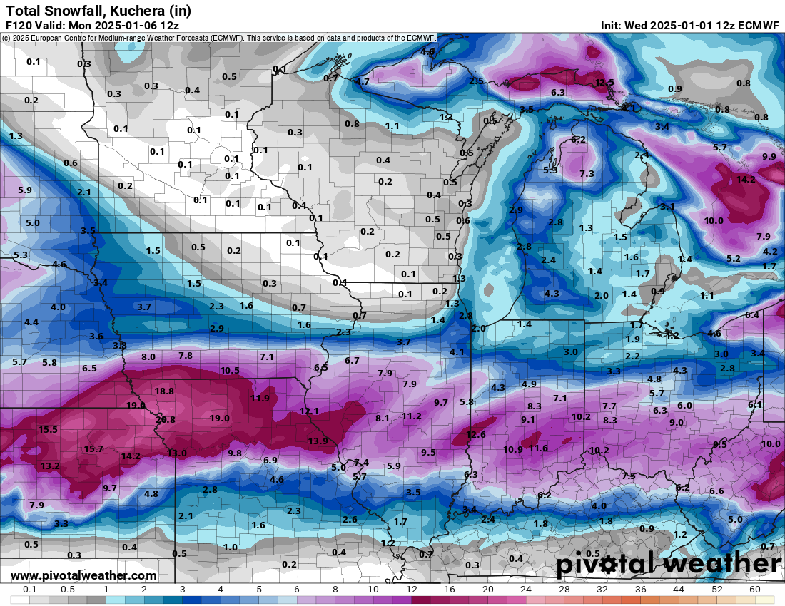
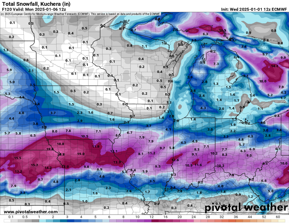
18z Euro is back south a bit.

-
I got 1.9" of snow today. I'm pretty happy with that. It's our first 1" snow event of the season.
-
We had some long dry stretches again this year, but I finished with 41" of precip, a whopping 16" more than 2023. Two periods that stand out are the very wet July (almost 9") and the 2-week period from late October to early November during which I received 7" of rain.
-
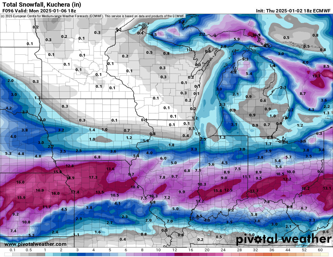
This storm has been as locked-in as any big storm gets days ahead of the event. Unfortunately, it's locked in south of Iowa. Northern Missouri should get crushed.
-
12z Euro... There is pretty good consensus with four days to go. The storm peaks in northern Missouri, then slowly fades as it heads east or even ese into the less favorable upper flow. That big dry pocket over MN/IA/WI/nIL makes me sad. As the storm organizes in Kansas, that would typically be very favorable for Iowa.
-
Those of us in the I-80 corridor really needed the big southeast Canada gyre to lift out, but it just isn't. It remains parked as the storm approaches, continuing the wnw flow across the lakes region.
-
The 00z GFS shows the eastern trough lifting out more than recent runs. That allows the storm to eject a bit farther north.
-

Winter 2024-25 Medium/Long Range Discussion
hawkeye_wx replied to michsnowfreak's topic in Lakes/Ohio Valley
Latest Euro... the model trend is clear. It will be difficult to get this up to the I-80 corridor with the big se Canada upper low holding strong.
-
I received 0.22" from this system. Some of the models were pretty bad, going back and forth from north to south. A few models, even up to last night, predicted several hours of light snow. We did not see a single flake.
-
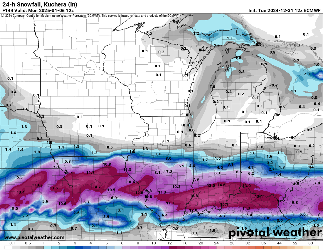
Models have all gone back south with tonight's system, so I will likely get nothing. Even southern Iowa won't get much, though... just some modest rain and a bit of wet snow.
-
Winter 2024-25 Medium/Long Range Discussion
hawkeye_wx replied to michsnowfreak's topic in Lakes/Ohio Valley
A change in the flow over the upper midwest on the latest op Euro appears to lead to the potential storm being weaker and well south of previous runs. -
Winter 2024-25 Medium/Long Range Discussion
hawkeye_wx replied to michsnowfreak's topic in Lakes/Ohio Valley
Booya! The 12z GFS has fully joined the Euro. A major wave moves into the pacNW, the eastern trough exits, but leaves cold air in place across the north, and we get a big snowstorm in the midwest.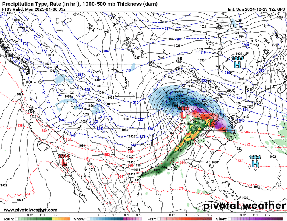
-
Winter 2024-25 Medium/Long Range Discussion
hawkeye_wx replied to michsnowfreak's topic in Lakes/Ohio Valley
It's still a week out, but, for the first time, the 06z GFS has joined the Euro in showing a much more amped wave moving into the pacNW, which then leads to a big event for the midwest. -
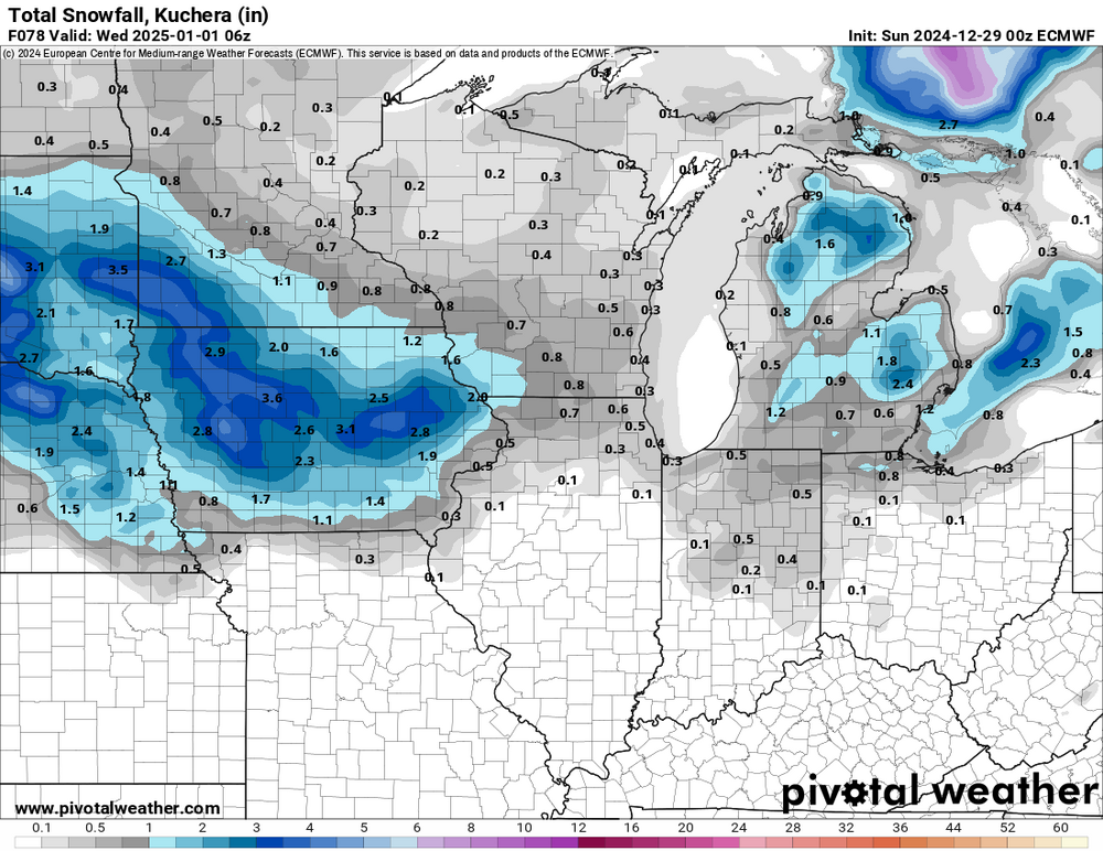
The Monday night/Tuesday system may end up a bit more interesting than it appeared yesterday. Models had mostly gone south, with both the GFS and Euro showing nothing here. However, the Euro has jumped back north quite a bit and now has 2-3 inches of wet snow through central Iowa. The NAM agrees with the Euro. Other models are still south.
-
We managed to reach the low 50s this afternoon thanks to a bit of sunshine.
-
Winter 2024-25 Medium/Long Range Discussion
hawkeye_wx replied to michsnowfreak's topic in Lakes/Ohio Valley
We are at least seeing the first tease of the season. The last couple Euro runs (and AI Euro) are the most bullish. The Euro then follows the storm with brutal cold... multiple days remaining below zero. -
Yesterday's rain system dropped 0.81" in my yard.
-
Fall/Winter '24 Banter and Complaints Go Here
hawkeye_wx replied to IWXwx's topic in Lakes/Ohio Valley
Not in our region, but certainly noteworthy.
-
Winter 2024-25 Medium/Long Range Discussion
hawkeye_wx replied to michsnowfreak's topic in Lakes/Ohio Valley
After the next week of mild air and light rain, the op Euro finally shows a major pattern change to active and cold...... and it STILL doesn't show a single dang flake of snow through the end of the run. It's unreal how difficult it can be to get snow around here. -
Fall/Winter '24 Banter and Complaints Go Here
hawkeye_wx replied to IWXwx's topic in Lakes/Ohio Valley
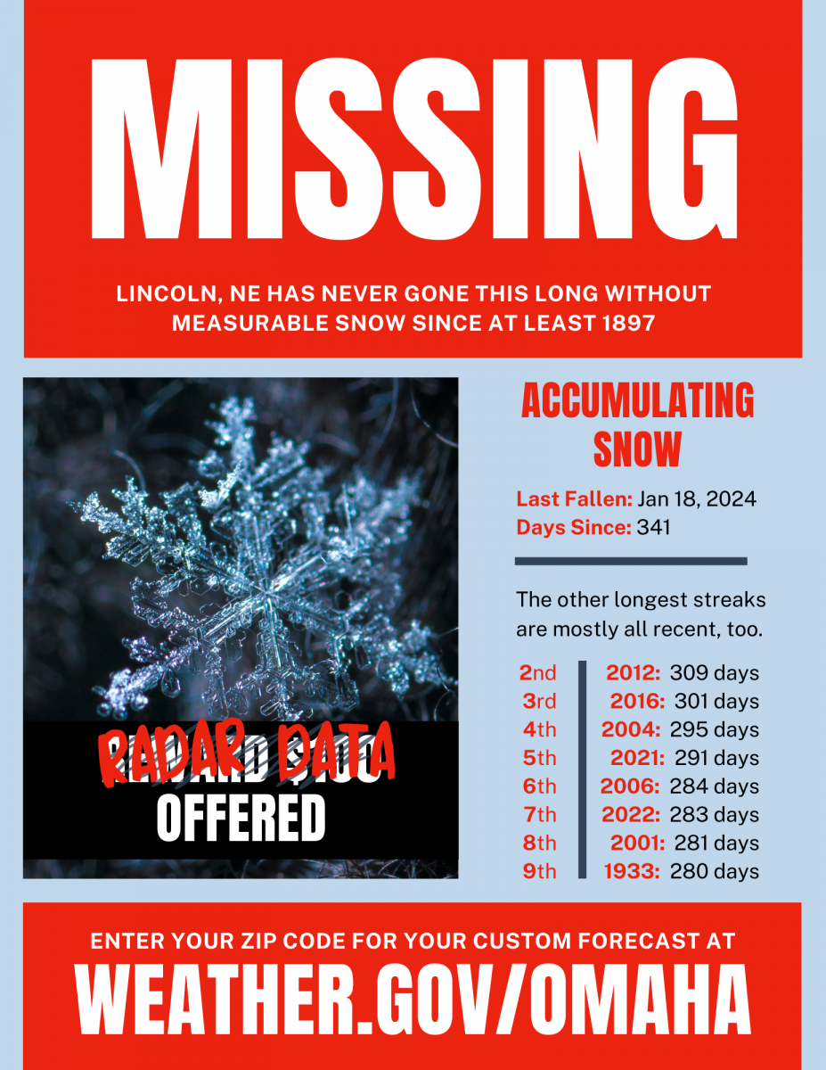
We will be going into the new year without a 1" snow event. We've received 1.5" total from four events... a few tenths here, a few there. -
I finished with 0.85" of rain. Locations around Ottumwa got 2+", which is why the ice was twice as thick down there.
-
We lost power for about 40 minutes. Tree branches have a good 1/4" of ice on them. There is up to 3/8" in spots. It's good that the icing is done. We have finally crept above freezing and the precip is diminishing. The worst icing was over southeast Iowa, where as much as 1/2 to 3/4" of ice built up on the trees.
-
We got a solid glaze overnight, but it's not a problem for trees so far. The surface is also rough/bumpy due to a little sleet that got mixed in. We should get one more batch of heavier precip before the temp rises above freezing.
-
Cedar Rapids hit 60º again today.
-
Cedar Rapids hit 60º. Des Moines hit 64º and Ames hit 65º.