hawkeye_wx
-
Posts
6,259 -
Joined
-
Last visited
Content Type
Profiles
Blogs
Forums
American Weather
Media Demo
Store
Gallery
Everything posted by hawkeye_wx
-
Our local NBC station recently announced a plan to dump all their mets and just use The Weather Channel, but they got backlash and halted the plan... for now.
-
We hit 54º today as the clouds moved in. That's three straight days of 50º. Mason City hit 62º today.
-
Models still disagree about Cedar Rapids. We could get a half inch or nothing. Most models have trended south, but a few are hanging on.
-

Fall/Winter '24 Banter and Complaints Go Here
hawkeye_wx replied to IWXwx's topic in Lakes/Ohio Valley
It definitely helps that the entire region has been snowless this winter. It would be much worse if I was sitting at 7" and Waterloo and Dubuque were at 35". -
We made it to the low 50s again today.
-
Winter 2024-25 Medium/Long Range Discussion
hawkeye_wx replied to michsnowfreak's topic in Lakes/Ohio Valley
Now models are punting the chance of any real snow until mid February. A few more punts are we'll be moving on to spring. -
Our low-water 3" of snow is vanishing quickly today.
-
Fall/Winter '24 Banter and Complaints Go Here
hawkeye_wx replied to IWXwx's topic in Lakes/Ohio Valley
Unsurprisingly, all the snow along the gulf coast is already gone. -
This weak disturbance barely showed up on some models, but it really over-performed across east-central Iowa. It started early this morning and it snowed here all day. My storm total is pretty solid 3.3". The first inch was 10:1 and the next two inches were 20:1.
-
Winter 2024-25 Medium/Long Range Discussion
hawkeye_wx replied to michsnowfreak's topic in Lakes/Ohio Valley
This morning's EPS is the first decent-looking run in a long time. In the 10-15 day range, it has a western trough, with snow-producing waves getting ejected into the midwest. -
Another nickel-and-dimer this morning. I've picked up 1.1" so far.. A bit more could fall through this afternoon.
-
Fall/Winter '24 Banter and Complaints Go Here
hawkeye_wx replied to IWXwx's topic in Lakes/Ohio Valley
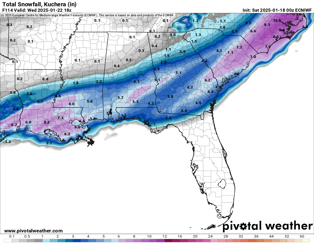
There are people in New Orleans showing measurements of 12". I have lived in Cedar Rapids for 50 years and I have never measured 12" from any storm. -
1/19/25 Eagles Playoff Winter Storm obs
hawkeye_wx replied to Ralph Wiggum's topic in Philadelphia Region
I was looking forward to watching heavy snow during the Eagles game, but so far it is rather disappointing. The precip is too scattered. -
Winter 2024-25 Medium/Long Range Discussion
hawkeye_wx replied to michsnowfreak's topic in Lakes/Ohio Valley
It's amazing how stuck the pattern is this winter. It doesn't seem to matter which phase the MJO is in. We just cannot get a trough in the west.
-
Fall/Winter '24 Banter and Complaints Go Here
hawkeye_wx replied to IWXwx's topic in Lakes/Ohio Valley
Man, this winter is really brutal for snow lovers. I can't remember anything like this. An entire winter with little to no hope of anything is astonishing. Day after day, the ensembles out to 15 days are bone dry. -
Fall/Winter '24 Banter and Complaints Go Here
hawkeye_wx replied to IWXwx's topic in Lakes/Ohio Valley
This is not a snowfall graphic we see very often.
-
We way over-performed today, warmed to 53º.
-
Fall/Winter '24 Banter and Complaints Go Here
hawkeye_wx replied to IWXwx's topic in Lakes/Ohio Valley
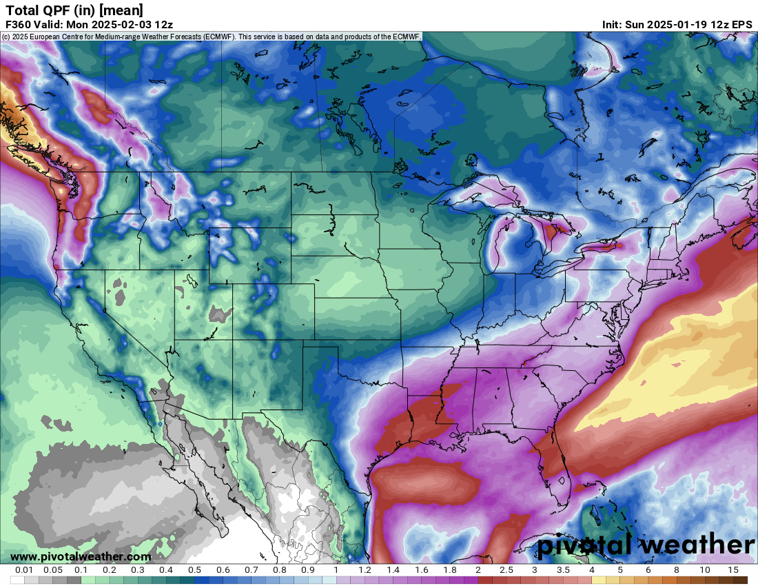
Houston and New Orleans may get accumulating snow early next week. -
0.9" of snow here this morning.
-
Winter 2024-25 Medium/Long Range Discussion
hawkeye_wx replied to michsnowfreak's topic in Lakes/Ohio Valley
Suppression, suppression, suppression... ad infinitum. The 12z deterministic Euro even has a strong deep south snow and ice storm. Ugh. -
Fall/Winter '24 Banter and Complaints Go Here
hawkeye_wx replied to IWXwx's topic in Lakes/Ohio Valley
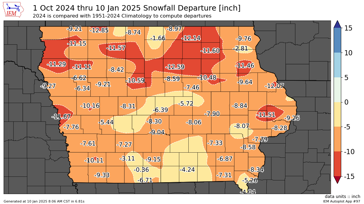
Parts of Iowa have still had no measurable snow this winter, and there is little to nothing in sight. Meanwhile, Birmingham and Atlanta are getting 2-3" this morning.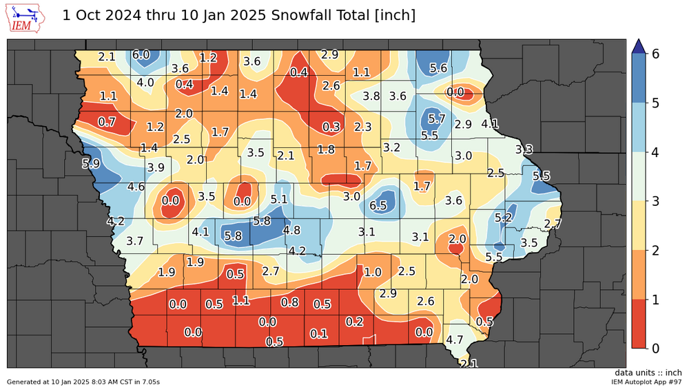

-
Winter 2024-25 Medium/Long Range Discussion
hawkeye_wx replied to michsnowfreak's topic in Lakes/Ohio Valley
Models have also really backed off of the extreme cold they were advertising a week ago. Now it just looks like some typical January cold. The latest model runs don't even have any sub-zero lows here. -
The deterministic/op Euro has actually shown a clear south and drier trend from 12z to 18z to 00z today.

-
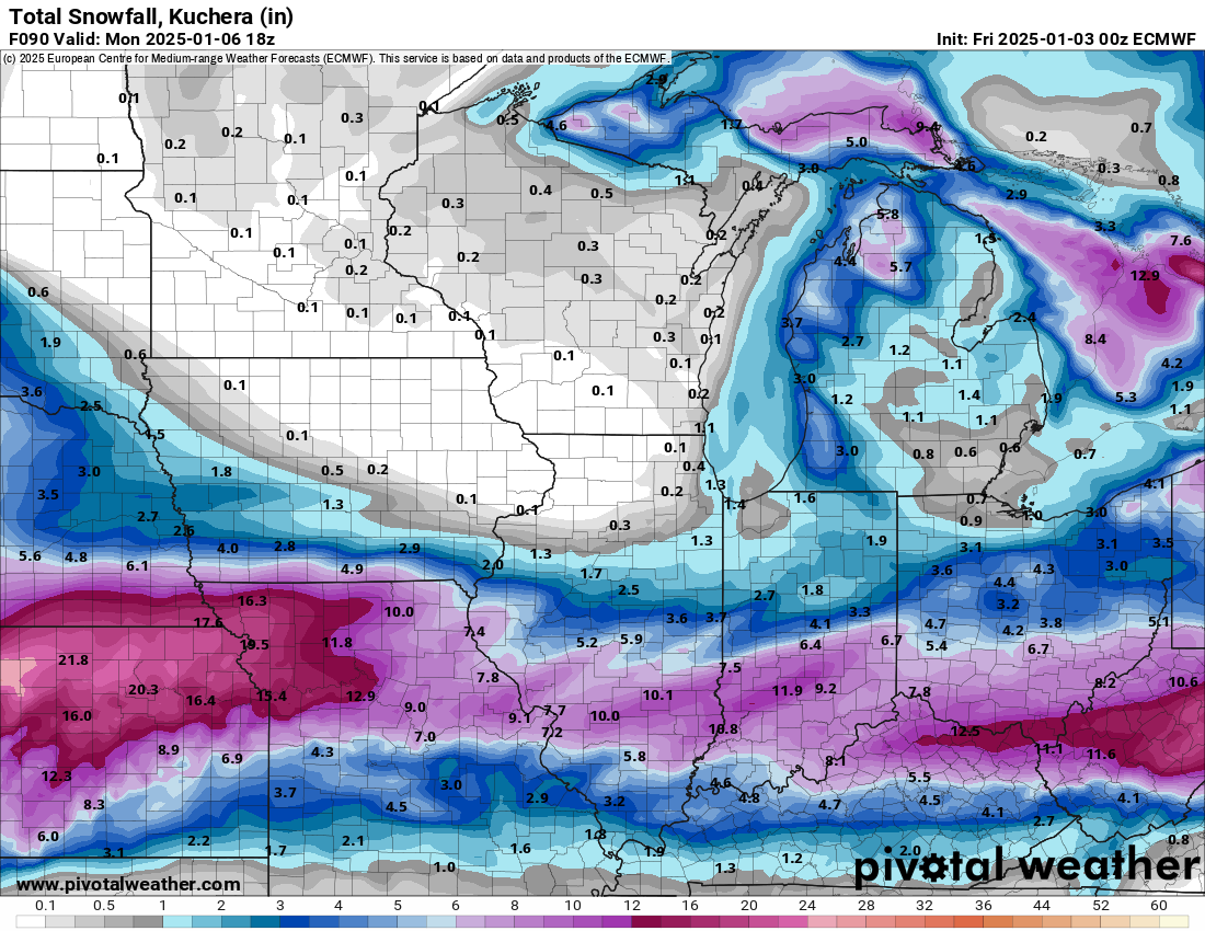
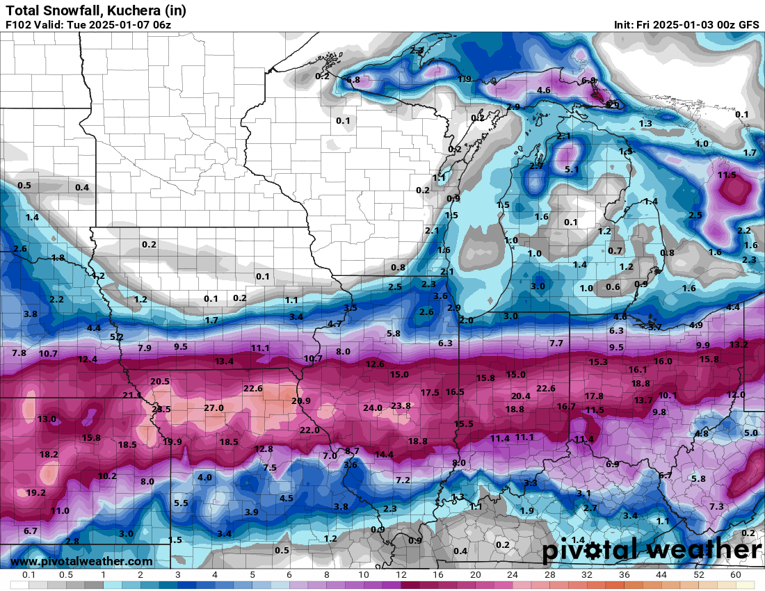
00z GFS.... south on the western end, north on the eastern end. The totals are wildly overdone, but I'm just following the track of the snow path.

-
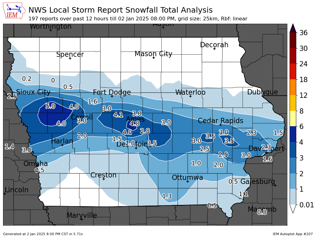
Here's the final Iowa snow map.