

hawkeye_wx
-
Posts
6,664 -
Joined
-
Last visited
Content Type
Profiles
Blogs
Forums
American Weather
Media Demo
Store
Gallery
Everything posted by hawkeye_wx
-
Why are the CAMs often bad with the lasting power and southward extent of an MCS like the one moving across Iowa this morning. Even as they rerun every 1-3 hours, they just can't see the south half of the line and keep trying to crap it out too quickly.
-
My rain total is 0.47", on the low end of guidance. This is about as awful as a June day can get. It feels like April. Let's get back to warm and humid with storms.
-
Models are trending south with the Sunday system. The CAMs are well south of my area with any storms. The Euro had been holding on a bit farther north, but it has caved this morning. I'm no longer expecting anything more than a light shower.
-
My rain total is 2.35". June is 8.37".
-
I've received another 2.1" of rain this morning. This puts June over 8". We are really getting clobbered this month.
-
60 mph is pretty common in severe storms. 74+ mph is not super rare, but it's much less common.
-
Here, farther north in the city, we got 50+ mph wind as the severe bowing missed a hair south. However, this is the second torrential comma head we've been under in the last week.
-
A bunch more rain behind the morning line boosted my daily total to 2.21". My June total is up to 5.97". Just about everyone in eastern Iowa got 1-2+", so the drought concern is fading.
-
No severe here, but we did get torrential rain. I got a very quick 1.25". At its peak it was close to 4"/hr, the heaviest rain I've seen in a while.
-
The MCV track looks south of what models have been predicting.
-
I got a quick half inch from the line racing northeastward out of Iowa. The wind was gusty, but below severe.
-
This week of high heat (DVN, a few days ago, had several days in the 90s, maxing at 96 today) is a bust. Monday-Wednesday we reached 80, 88, 83, with the rest of the week likely not even reaching 80.
-
There are no flood watches out, yet, but the CAMs are all dumping several inches of rain across parts of the se IA, n IL, ne MO area.
-
Despite a good-looking setup for eastern Iowa Wednesday into Wednesday night, all of the morning CAMs show almost all the storms forming northeast, east and south of this area.
-
On the visible satellite loop it looks like the remnant low of a tropical depression is lifting northward through eastern Iowa. The rain bands are very efficient. I got another 1.79" of rain overnight through this morning. The defo zone/pivot point of the meso low passed just west of me and produced a band of 3-4" of rain across that area. There was no thunder this morning, just tropical-style heavy rain. After getting only 1.90" of rain in May, I have already received 3.23" in the first week of June. The soil has been thoroughly replenished and the garden is thriving.
-
I hate when models back off as an event approaches. First, it was Friday (yesterday) that totally crapped out for this area. Now, the widespread 1-2" Sunday and Monday has been reduced to scattered showers, with more isolated heavy downpours. Some spots may get an inch, but others may get very little. Most of the rain on Monday has been shifted east.
-
I was fortunate to get 0.94" overnight and this morning because, overall, this disturbance did not drop the widespread 1-3" some models were advertising a day or two ago. Areas from Iowa City east and south got almost nothing. There was also zero lightning/thunder with this rain. It had also looked like Friday night would be a good storm/rain event across the area, but now that appears to be gone south, so there are some spots in ec/se Iowa that will get nothing from both nights.
-
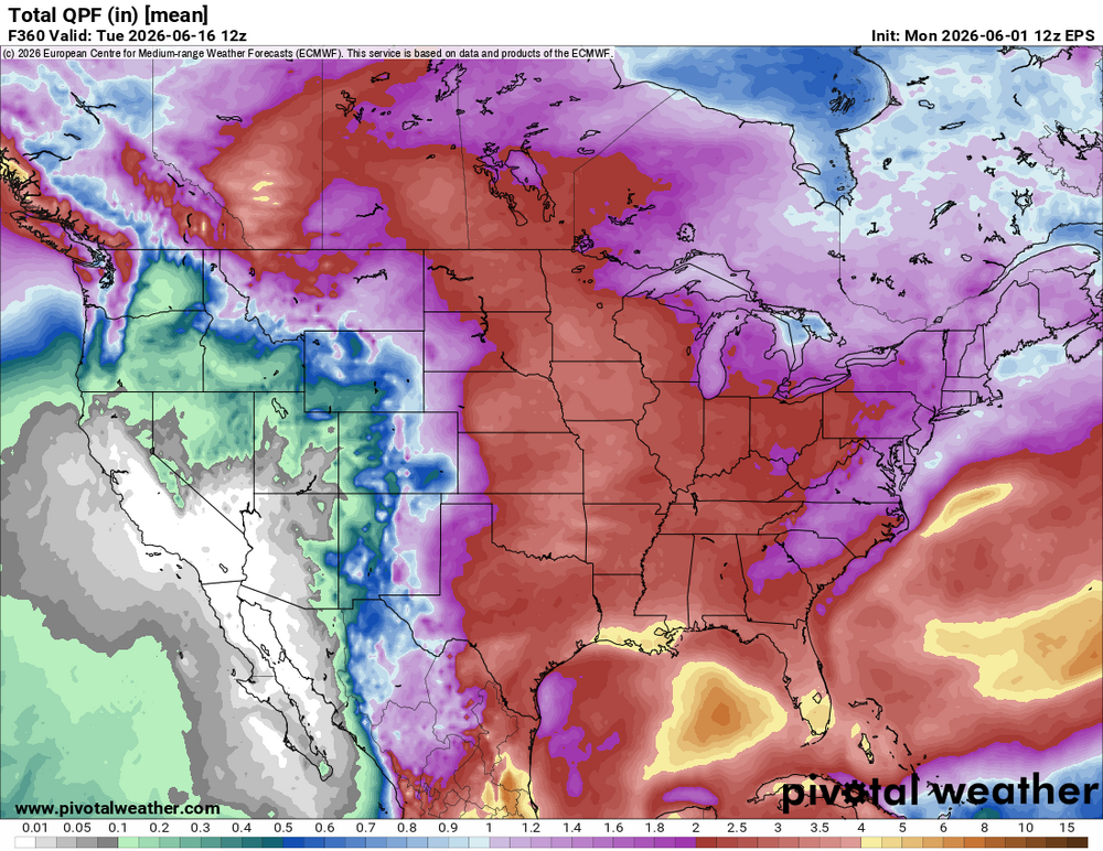
The lawns here are very noticeably browning. However, all the ensembles are spitting out an average of 2.5+" of rain over the next two weeks, which should hold off any drought for a while.
-
The low dews are leading to spectacular mornings and evenings. While it feels great, no humidity means no rain. This is the second time in five weeks we've gone two weeks without rain.
-
There is definitely some hope on the horizon. The pattern switches to wetter Friday. It feels like an eternity since we've had a thunderstorm. EPS mean
-
A super-dry blocking pattern in the middle of peak storm season sucks.
-
We're going into peak severe season and it's going to be snoozeville for at least the next two weeks.
-
The CAMs were wrong about everything getting stuck in Missouri and nothing getting up here. There were no strong storms around here, so in that regard the weekend was a dud. However, another round of solid rain dropped 0.64" in my yard overnight. Four decent rounds of rain through the weekend added up to 1.86". The rest of the month is looking drier and fairly boring again.
-
The Friday-Monday warmth has been underwhelming. DVN had every day in the 85-87º range, but we've come up a few to several degrees short each day. Today's it's only in the mid 70s.
-
Got another 0.47" overnight into this morning, so at least we are getting something from each round. My weekend total is 1.22". Models are still suggesting almost everything will be down in Missouri later today.


