hawkeye_wx
-
Posts
6,260 -
Joined
-
Last visited
Content Type
Profiles
Blogs
Forums
American Weather
Media Demo
Store
Gallery
Everything posted by hawkeye_wx
-
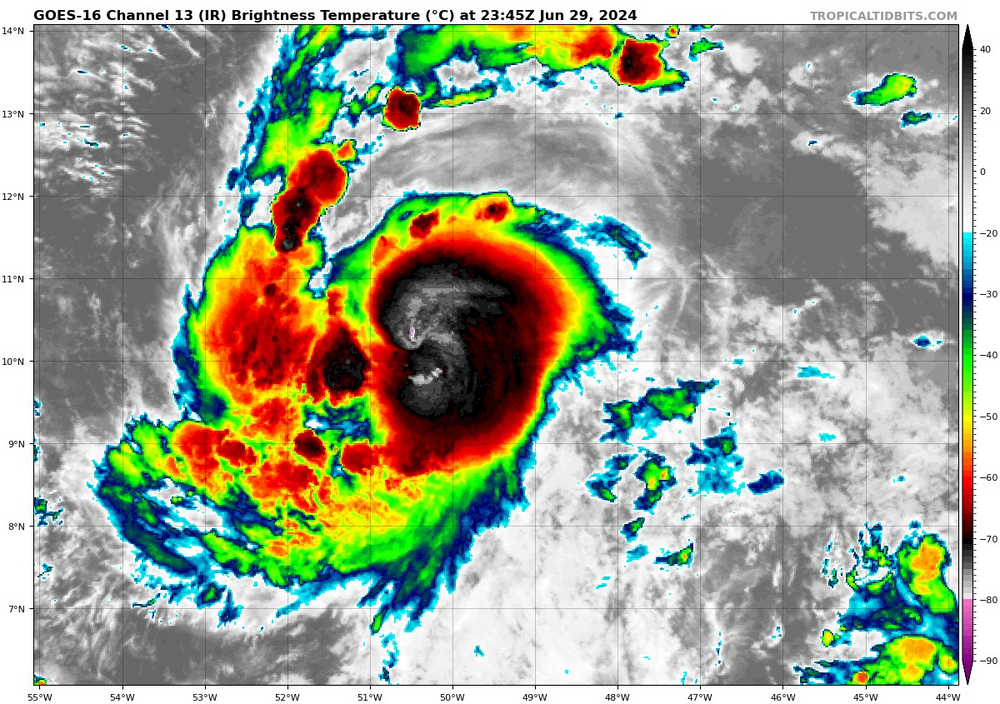
 The second recon pass found 965 mb with a dropsonde.
 -
Dropsonde says about 963 mb, so it's an 11 mb drop since the last recon report several hours ago.
-
The models are all too far south with the track today. The eye of Beryl is now near the point that is due south of the Isle of Youth and west of Grand Cayman. None of the GFS, Euro, Canadian, ICON, are that far north. And, the Cayman radar shows the wnw track has not stopped.
-
This evening's heavy rain event was a big bust for the Ames to Cedar Rapids corridor. The line had a break in it that passed directly over me, so I only got 0.38". My daily total is 0.92".
-
Remnant light to moderate rain from the western Iowa storms dropped 0.48" here this morning. It has been quite a while since we've had a good storm.
-
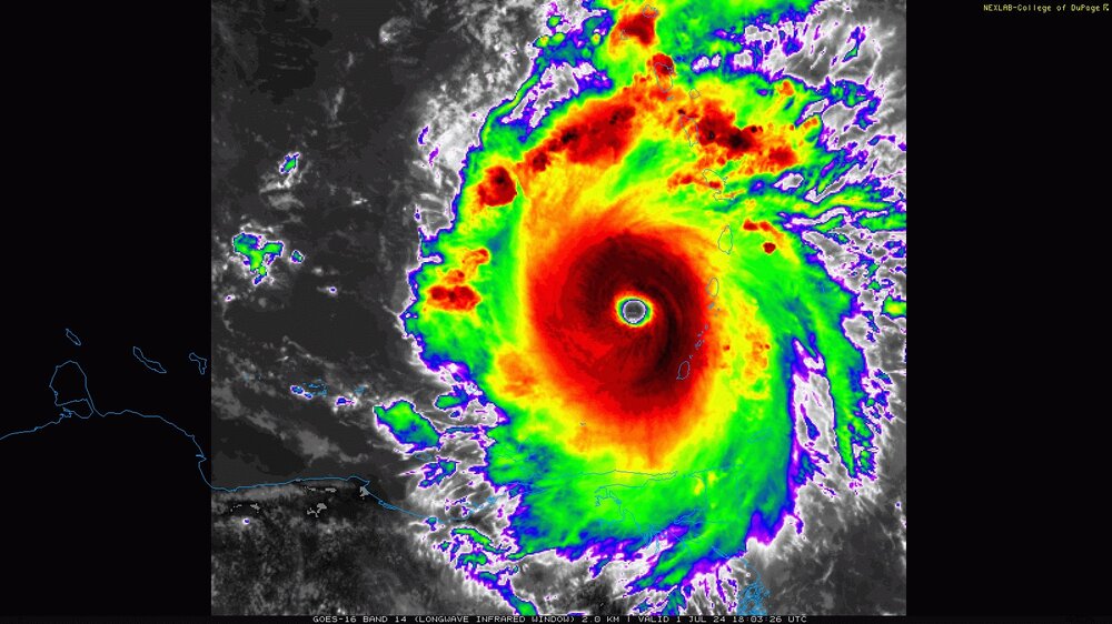
NHC officially says 938 mb, 155 mph.
-
Recon is scheduled to be in there in only 2.5 hours from now. It should still be at/near peak. The planes are flying from St. Croix, so it's a very short flight at this point.
-
Remember the days before the GOES-R satellites, when we got images every 15 minutes with a delay (and a couple times a day there was a 30+ minute break between images), and the old GOES satellites did not even give us any image below the north half of the Caribbean? Now we get a full, beautiful image every minute, in real time. GOES-R has been amazing for hurricane tracking.
-
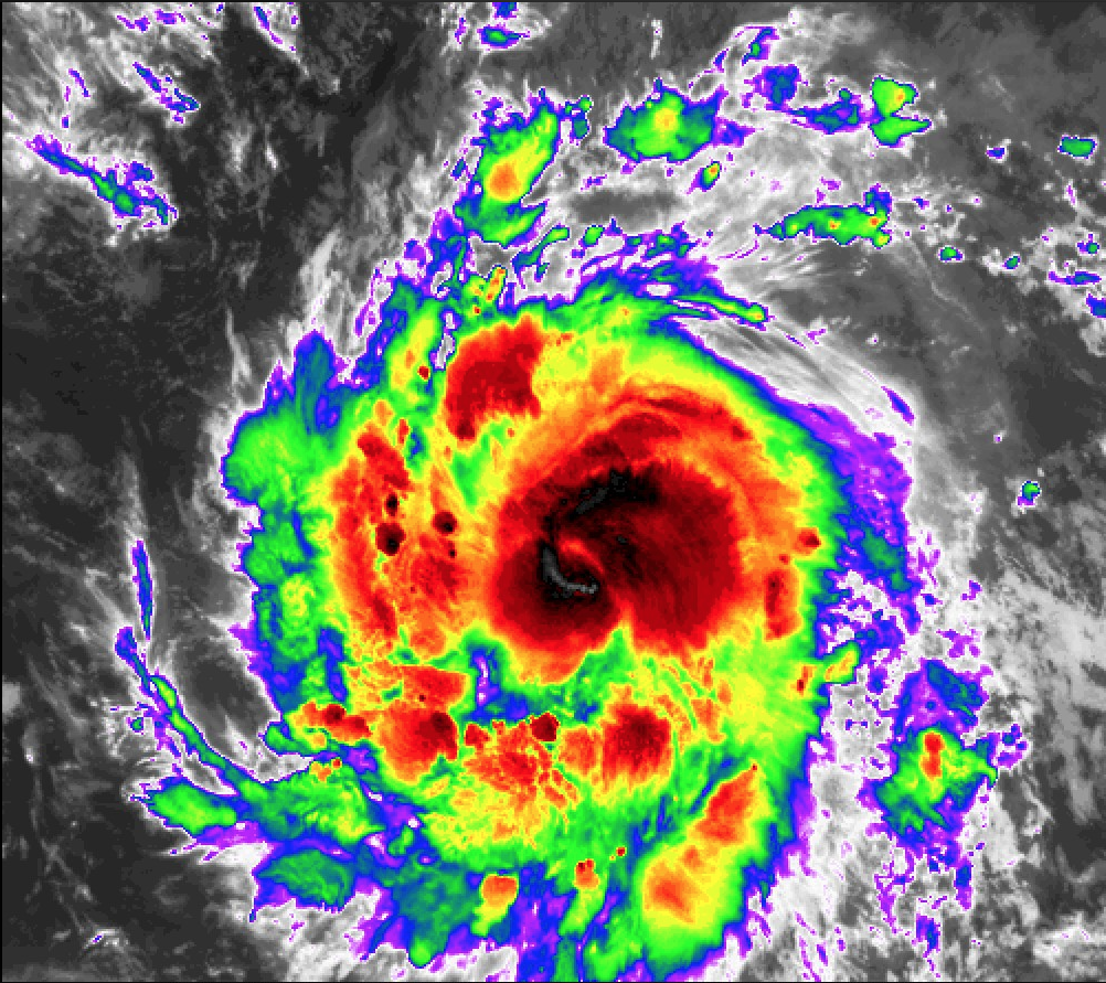
Beryl continues to strengthen as it moves out into the Caribbean. The CDO and eye are becoming more circular and crisp. The next recon plane is scheduled to be in the storm at 23:00z.
-
I don't recall there being a hurricane in this far south location since Ivan in '04. It doesn't happen often. The vast majority of storms that form in the MDR lift northward away from 10N pretty quickly as they organize.
-
Barbados is very fortunate that Beryl has tracked a good degree farther south than earlier projected.
-
960 mb extrap, 132 kt SFMR on latest recon pass.
-
Beryl is not wasting time tonight. It has developed a nice eyewall and it is about to pop the eye on satellite.

-
After working all day to moisten up the north side of the core, Beryl has finally managed to wrap the convection initiation point around.
-
I finished with 1.44" of rain today. I will still finish June ~1.50" below avg, but this was a nice win. Tuesday looks like another chance of good rain.
-
Yay, this morning's rain event did not crap out. I am approaching an inch, which is very much needed. There is no lightning/thunder, so it's not exciting, but I'll take a gentle soaker.
-
The storms popped just barely south of me today, so I got nothing. We average over 5 inches in June, but I've only received 2".
-
All the storms went around me this evening.
-
At the last minute this evening, as isolated cells were dying out, one more heavy cell popped right over me and dumped 0.43". My daily total is 1.16". We needed that.
-
An area of decent rain popped in my area overnight into this morning. I picked up a welcome 0.73". Much heavier rain fell just south, where some locations got 2-3".
-
The rain really shut off when the calendar flipped to June. I've received only 1.03", with most of that falling on June 1st. Ottumwa has received only about 0.20" all month. The overnight rain was another bust. The storms out west crapped out long before reaching eastern Iowa. There's just not much support.
-
It was 92º with a dew in the upper 60s here today, with wind, so it's wasn't bad.
-
Summer 2024 Medium/Long Range Discussion
hawkeye_wx replied to Chicago Storm's topic in Lakes/Ohio Valley
The next ten days look wet and exciting in the nw sub, while the rest of the sub sees little or nothing.
-
I only received 0.11" of rain from the early week system, so pretty much a bust. Today the wind is gusting over 45 mph. I had to move a bunch of my newly-planted flower pots into the garage to prevent them from being ripped apart.