hawkeye_wx
-
Posts
6,662 -
Joined
-
Last visited
Content Type
Profiles
Blogs
Forums
American Weather
Media Demo
Store
Gallery
Everything posted by hawkeye_wx
-

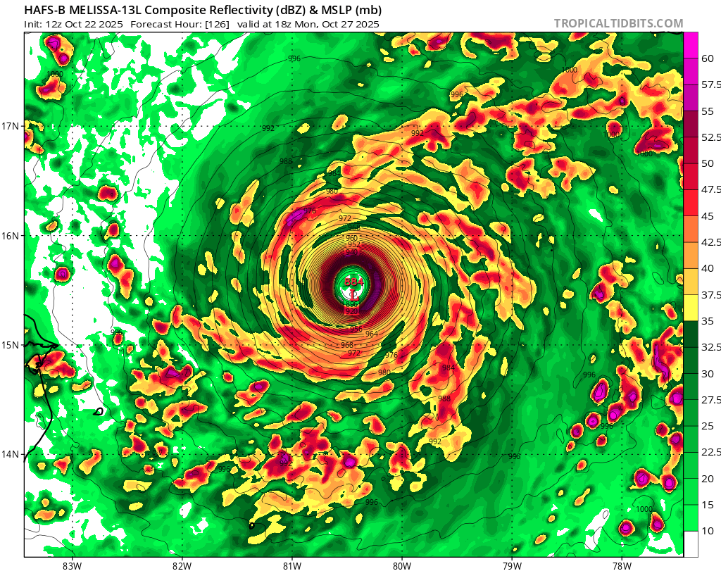
Major Hurricane Melissa - 892mb - 185mph Jamaica landfall
hawkeye_wx replied to GaWx's topic in Tropical Headquarters
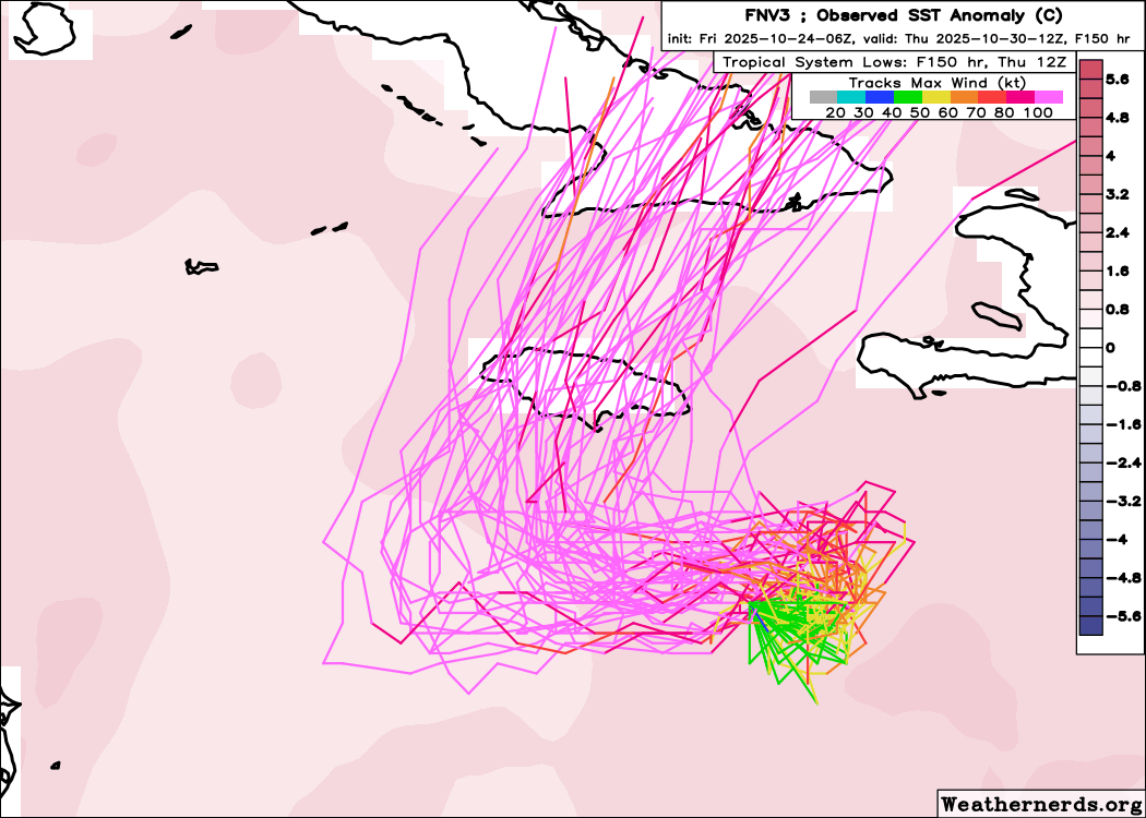
06z Google.... almost all tracks now over Jamaica.
-
Major Hurricane Melissa - 892mb - 185mph Jamaica landfall
hawkeye_wx replied to GaWx's topic in Tropical Headquarters
This is a weak and messy circulation.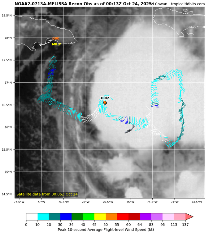
-
Major Hurricane Melissa - 892mb - 185mph Jamaica landfall
hawkeye_wx replied to GaWx's topic in Tropical Headquarters
Google DeepMind ensembles have shifted back west and south again.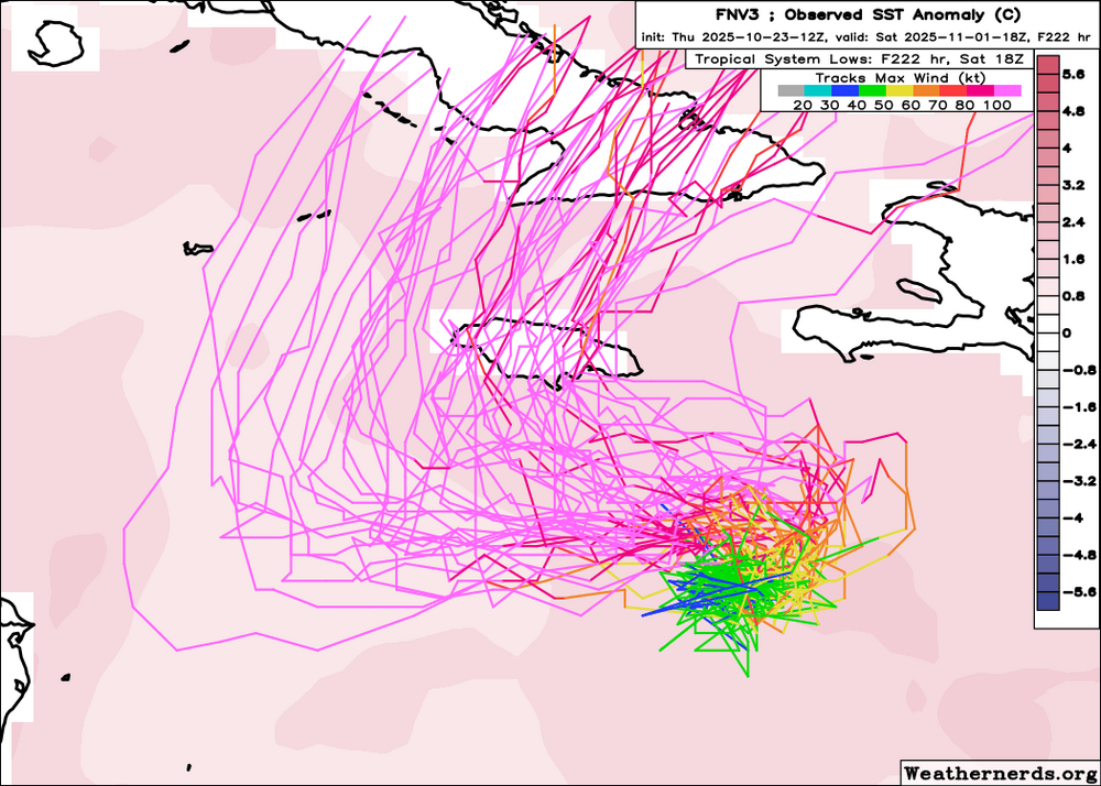
-
Major Hurricane Melissa - 892mb - 185mph Jamaica landfall
hawkeye_wx replied to GaWx's topic in Tropical Headquarters
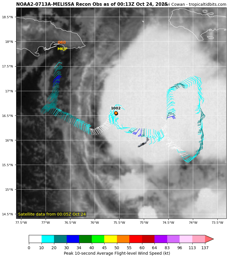
Based on the final recon pass and the visible loop, it appears the center has jogged northwest, and is now west of the NHC forecast. -
Major Hurricane Melissa - 892mb - 185mph Jamaica landfall
hawkeye_wx replied to GaWx's topic in Tropical Headquarters
HAFS models have jumped northeast again this morning. Now they hit Jamaica from the east. -
Upper 20s were scattered across western, northern, and east-central Iowa this morning. The Cedar Rapids airport briefly hit 28º. Here in the city there was just a light skin of ice on the bird bath and some light frost. Tomorrow morning should be a bit colder.
-
Major Hurricane Melissa - 892mb - 185mph Jamaica landfall
hawkeye_wx replied to GaWx's topic in Tropical Headquarters
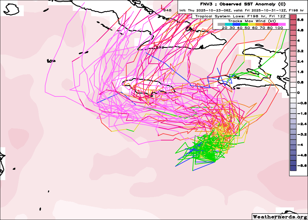
There has been a northeast shift on the models overnight. The Google DeepMind ensembles have come into much better agreement that Melissa will now get pulled northeastward first before it turns west. All of yesterday's tracks that went well southwest of Jamaica are gone. The HAFS models agree with this.
-
Major Hurricane Melissa - 892mb - 185mph Jamaica landfall
hawkeye_wx replied to GaWx's topic in Tropical Headquarters
12z Google model.... more tracks missing Jamaica to the west
-
Major Hurricane Melissa - 892mb - 185mph Jamaica landfall
hawkeye_wx replied to GaWx's topic in Tropical Headquarters
HAFS-B... when it's well sw of Jamaica.
-
Major Hurricane Melissa - 892mb - 185mph Jamaica landfall
hawkeye_wx replied to GaWx's topic in Tropical Headquarters
Latest Euro The new HAFS is going sub-900. -
Major Hurricane Melissa - 892mb - 185mph Jamaica landfall
hawkeye_wx replied to GaWx's topic in Tropical Headquarters
The surface center has once again been spit out toward the west as the convection is unable to hold onto it. -
As often happens, our low temp the next couple mornings has been gradually lowered as it approaches. Now we may get to near freezing. I have to get the rest of my garden cuttings today before plants get zapped.
-
Major Hurricane Melissa - 892mb - 185mph Jamaica landfall
hawkeye_wx replied to GaWx's topic in Tropical Headquarters
Here's the latest Google model. -
Major Hurricane Melissa - 892mb - 185mph Jamaica landfall
hawkeye_wx replied to GaWx's topic in Tropical Headquarters
It appears the surface center was pulled a bit northeast by the overnight convection, but the future track has not changed. The 00z and 06z Euro show what will happen if Melissa can stay far enough sw to get caught under the building ridge this weekend. It would likely explode into a spectacular hurricane. -
Major Hurricane Melissa - 892mb - 185mph Jamaica landfall
hawkeye_wx replied to GaWx's topic in Tropical Headquarters
The surface center continues to track sw of the NHC forecast. -
Major Hurricane Melissa - 892mb - 185mph Jamaica landfall
hawkeye_wx replied to GaWx's topic in Tropical Headquarters
This is a very weak system. As you say, if it's even closed it's just barely. All of the convection was lost this morning, so it may even be weakening. It will likely have another nice convective blow-up just east of the center tonight. -
Major Hurricane Melissa - 892mb - 185mph Jamaica landfall
hawkeye_wx replied to GaWx's topic in Tropical Headquarters
12z Euro -
Major Hurricane Melissa - 892mb - 185mph Jamaica landfall
hawkeye_wx replied to GaWx's topic in Tropical Headquarters
The new Euro is more like its ensembles. It tracks a bit farther sw over the next couple days, which then allows it to get caught under the ridge and turned toward the wsw. It also blows up south of Jamaica. -
Major Hurricane Melissa - 892mb - 185mph Jamaica landfall
hawkeye_wx replied to GaWx's topic in Tropical Headquarters
The surface center is leaving the convection behind again this morning. -
Major Hurricane Melissa - 892mb - 185mph Jamaica landfall
hawkeye_wx replied to GaWx's topic in Tropical Headquarters
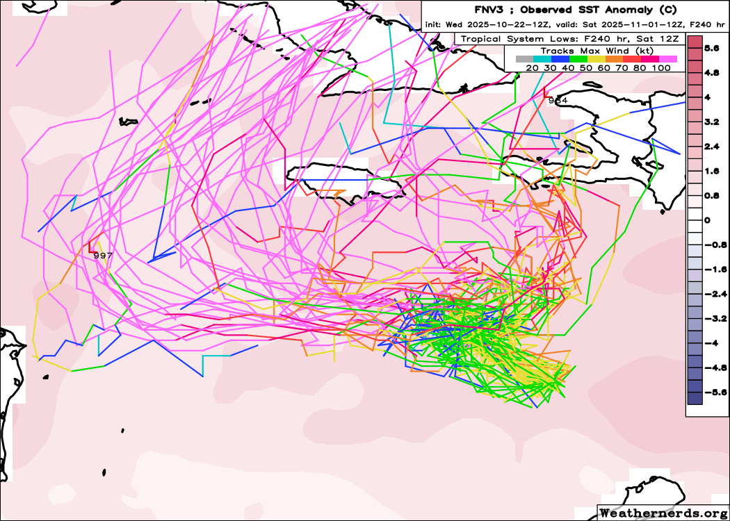
12z Euro is similar to past runs.... stays relatively weak and is able to not get pulled north early, then blows up south of Jamaica and is quickly yanked north by the next trough. -
Major Hurricane Melissa - 892mb - 185mph Jamaica landfall
hawkeye_wx replied to GaWx's topic in Tropical Headquarters
The GFS and ICON show the large differences that occur on Wednesday. At that point, when this system is south of Hispaniola, the GFS suddenly blows it up into a rapidly-strengthening hurricane and drives it north across the island. The ICON, on the other hand, does not develop it much until Sunday. It still feels a northward tug, but it remains too weak and shallow to get pulled further north, so it waits for the ridge to build in and turn it westward, at which point it blows up. Regarding the current state of the system, I'm not seeing any close surface circulation this morning. The center of surface spin is out ahead of most of the convection. -
Major Hurricane Melissa - 892mb - 185mph Jamaica landfall
hawkeye_wx replied to GaWx's topic in Tropical Headquarters
So this system does appear to be organizing earlier than some models were predicting. They now mostly develop it before it reaches the central Caribbean. However, there are still two camps. The GFS and Euro AIFS are still lifting it northward over Hispaniola, while the Euro and ICON begin to turn it north, but then a rebuilding ridge to the north causes the system to stall and turn back to the west. -
A series of decent showers added up to 0.40" here overnight.
-
Major Hurricane Melissa - 892mb - 185mph Jamaica landfall
hawkeye_wx replied to GaWx's topic in Tropical Headquarters
The GFS has a piece of energy in the sw Caribbean that competes with the energy coming in from the east. That also causes it to stop much earlier and end up much farther northeast. The Euro, on the other hand, has the main wave remaining the dominant energy, and also has stronger ridging to the north, which keeps the system moving westward. -
We got a little rain yesterday, enough to wet the surface, but then overnight a nice soak boosted my total to 0.60".