hawkeye_wx
-
Posts
6,260 -
Joined
-
Last visited
Content Type
Profiles
Blogs
Forums
American Weather
Media Demo
Store
Gallery
Everything posted by hawkeye_wx
-
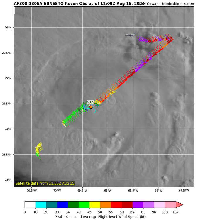
Based on the new recon data from the east/southeast side, 90 mph may be generous.
-
The final recon pass tonight found ~977 mb with a dropsonde.
-
38º in Davenport this morning.
-

2024 Atlantic Hurricane Season
hawkeye_wx replied to Stormchaserchuck1's topic in Tropical Headquarters
This wave is fading on models, at least until it reaches the western Caribbean. -
We really needed rain. After nearly 9 inches in July, we had only received an inch in August. Fortunately, Cedar Rapids hit the jackpot overnight. Storms trained over the area for a few hours. I picked up 2.41". Radar suggests 3+" fell on the east side of the city.
-
It is currently 94/81/115 here in Cedar Rapids. The NWS has had 98º for our high for a few days, but they are always too hot on the hottest days. It's extremely rare for CR to reach the upper 90s. Frankly, while I'm very glad to have air conditioning, I actually get cold inside so I go outside once in a while. This oppressive heat feels great for a few minutes at a time.
-
This summer has not been hot at all. June had seven 90º days, July had two, and August has had zero, with none in sight. The summer high temp was 93º back in mid June.
- 231 replies
-
- 1
-

-
- absolute trainwreck?
- abandon all hope?
- (and 1 more)
-
I was able to get almost an inch of rain overnight into this morning. It was well-timed because the first two weeks of August were very dry and the next week or two looks dry as well.
-
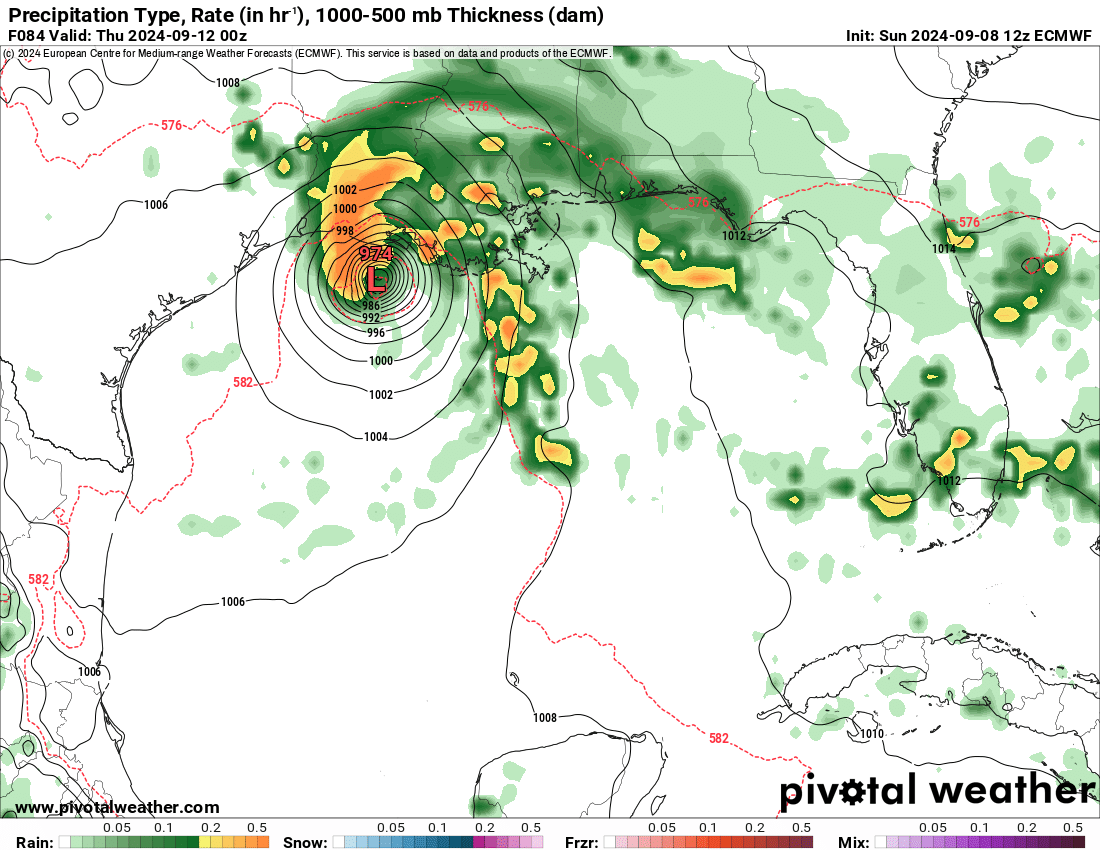
The storm has broadened, so the core is lagging a bit. Recon is finding only tropical storm wind on the west side, and even within the core on the right side. Hurricane-force wind is displaced well east of the center.
-
The surface center is still weak and displaced to the wsw of the nice mid-level center we see on radar.
-
Last night's line of storms held together better than I expected. I got a nice storm out of it, with rain that totaled 0.58". My final July rain total is 8.66".
-
Tonight's big event for my area has kinda been ruined by all the recent action to the southwest. All we have this evening is an outflow-dominated, bubbly line moving through central Iowa. There probably won't be much left when it gets here later.
-
The MCS train has not budged from its track through Ottumwa the last few days. Ottumwa has received 6-7" of rain.
-
As expected, I only got some light anvil rain like Cyclone... about 0.15". The MCS track has been locked in for the last few days. Ottumwa had been the driest spot in Iowa, getting missed repeatedly over the last couple months, but they've been hit by at least five MCSs this week that have dropped several inches of rain.
-
The morning MCS activity across the sw half of Iowa likely ended any chance of storms here until Wednesday night.
-
I finished last night with 1.01". It was heavier just south of me where the storms trained. My July total is up to 7.97", which makes this my wettest July since I began keeping records in 2007. This is just one of those months in which we are maxing out every event. We aren't done, either. There may be more MCS activity Tuesday and Wednesday nights.
-
One more batch of bubbly showers and storms this morning boosted my rain total to 2.05". My July total is 6.96". This is our wettest July since 2008 and the first wet July since 2017. The last several have been well below average.
-
We've had small cells pop up for the last few days. The last two days I only got a tenth or so from each, but we got lucky early this morning when a potent cell blew up over Cedar Rapids. We got vivid lightning, some wind, and very heavy rain that totaled 1.74". My July total is 6.65".
-
2024 Short/Medium Range Severe Weather Discussion
hawkeye_wx replied to Chicago Storm's topic in Lakes/Ohio Valley
I got 2.56" of rain (still raining lightly), the most from a single storm in about ten years I think. Unfortunately, the wind blew it against the house for an hour, so it ran down the foundation and into the basement. -
2024 Short/Medium Range Severe Weather Discussion
hawkeye_wx replied to Chicago Storm's topic in Lakes/Ohio Valley
97 mph gust reported just west of Dubuque. -
2024 Short/Medium Range Severe Weather Discussion
hawkeye_wx replied to Chicago Storm's topic in Lakes/Ohio Valley
It is real nasty here. Torrential rain, wind sustained at 40 mph, gusting to 60 mph for the last 10+ minutes.... easily our worst storm since the derecho. -
2024 Short/Medium Range Severe Weather Discussion
hawkeye_wx replied to Chicago Storm's topic in Lakes/Ohio Valley
Severe wind has now hit Cedar Rapids. My trees just held on during some big gusts. -
2024 Short/Medium Range Severe Weather Discussion
hawkeye_wx replied to Chicago Storm's topic in Lakes/Ohio Valley
Well, the sw tail of the storm is building back to the wsw, so I'm getting hit good now. There have been a bunch of close lightning strikes, something we don't often see from late-night MCSs. One strike knocked my power out for a second. The sirens are going off. -
2024 Short/Medium Range Severe Weather Discussion
hawkeye_wx replied to Chicago Storm's topic in Lakes/Ohio Valley
I just went out and put supports on a bunch of plants, getting drenched in the process (81º dew). I come inside and the radar shows this first severe line is going to miss north.