hawkeye_wx
-
Posts
6,274 -
Joined
-
Last visited
Content Type
Profiles
Blogs
Forums
American Weather
Media Demo
Store
Gallery
Everything posted by hawkeye_wx
-
I lost a strip of shingles from the corner of my roof yesterday during the howling wind. The forecast had 20 gusting to 35, but we got 30 gusting to almost 50.
-
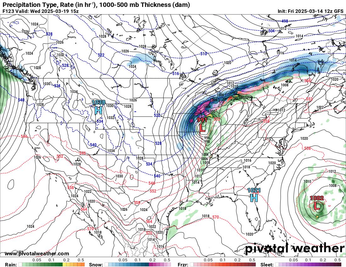
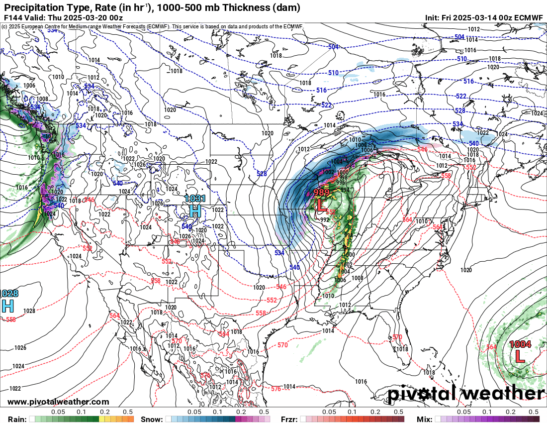
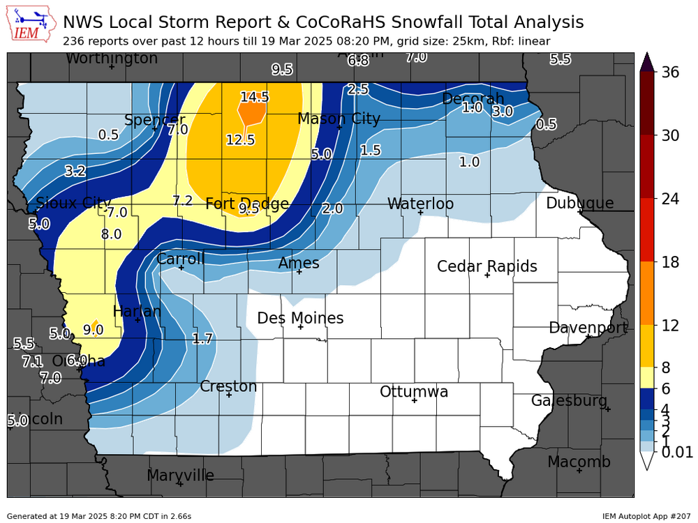
Some real nice snow totals in Iowa.
-
There was a nw trend with the snow band a day or two ago. Over the last few model runs, it has reversed and is trending back southeast, away from MSP.
-
2-4" of snow fell overnight in the southeast corner of Iowa.
-

March 14-15 Severe Weather Outbreak
hawkeye_wx replied to HillsdaleMIWeather's topic in Lakes/Ohio Valley
I'm on the west side. The red cell moved right over my house, but it didn't produce anything noteworthy... maybe 50 mph? with some decent lightning and not much rain. -
March 14-15 Severe Weather Outbreak
hawkeye_wx replied to HillsdaleMIWeather's topic in Lakes/Ohio Valley
Really? Here in the city it was no big deal. -
March 14-15 Severe Weather Outbreak
hawkeye_wx replied to HillsdaleMIWeather's topic in Lakes/Ohio Valley
I got some lightning, thunder and some gustiness, but overall a big dud for much of eastern Iowa. -
March 14-15 Severe Weather Outbreak
hawkeye_wx replied to HillsdaleMIWeather's topic in Lakes/Ohio Valley
For a week all models have shown a strong line moving through eastern Iowa this evening. So far, the line approaching my area is weak crap. The 40s dews are not helping. -
March 14-15 Severe Weather Outbreak
hawkeye_wx replied to HillsdaleMIWeather's topic in Lakes/Ohio Valley
The Weather Channel has a Torcon of 9 out of 10 for Jackson, MS tomorrow. -
Cedar Rapids is up to 81º.
-
Spring 2025 Medium/Long Range Discussion
hawkeye_wx replied to Chicago Storm's topic in Lakes/Ohio Valley
The GFS looks nearly identical to the Euro, with this morning's run being a bit farther south.
-
March 14-15 Severe Weather Outbreak
hawkeye_wx replied to HillsdaleMIWeather's topic in Lakes/Ohio Valley
v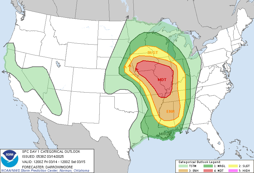
-
Spring 2025 Medium/Long Range Discussion
hawkeye_wx replied to Chicago Storm's topic in Lakes/Ohio Valley
Models are getting a bit frisky with the midweek storm. The new Euro is stronger and farther south. Other models are farther north. This Euro run has 70º here Tuesday and then heavy snow and wind Wednesday.
-
Spring 2025 Medium/Long Range Discussion
hawkeye_wx replied to Chicago Storm's topic in Lakes/Ohio Valley
Models continue to tease some snow across Iowa mid next week, right after we hit 70º again early in the week. -
March 14-15 Severe Weather Outbreak
hawkeye_wx replied to HillsdaleMIWeather's topic in Lakes/Ohio Valley
This line is going to race northeastward across eastern Iowa, will be in and out in a flash. -
A batch of high clouds earlier in the day held us back a little, but they cleared and we have surged to 74º. Southwest Iowa is in the low 80s.
-
The first red-winged blackbird showed up on my seed feeder this morning. Robins will surely arrive this week.
-
Daffodils should be shooting up by the end of the week.
-
Tuesday is now looking like the coolest day of the week. The Euro has upgraded both Thursday and Friday to 70+.
-
It snowed pretty hard here for several hours this morning. However, it took 0.47" of liquid to get 2.3" of snow. Iffy temps really cut down on the total.
-
The north models were wrong this morning. The heavier snow band remained parked through Cedar Rapids. I finished with 2.3". It probably would have been double that if the temp was a couple degrees colder.
-
The GFS had been the one model bringing a cold front through Monday night, which would ruin our chance at 70s Tuesday. Other models kept pushing the big warmth, even the Euro. It appears the GFS was correct. We'll still be warm, but maybe not quite as warm as models had been suggesting.
-
I got 1.5" of snow overnight. Last hour, huge flakes were dumping down. Now in between bands, it will likely start to melt. The marginal temp across the state is making it difficult to accumulate well.
-
Models have shifted the Iowa snow band north today, maybe putting me on the southern edge. 1-3" looks like a good range.
-
I picked up 2 inches of snow this morning. My storm total precip is a real nice 1.90".