

mahantango#1
-
Posts
3,278 -
Joined
-
Last visited
Content Type
Profiles
Blogs
Forums
American Weather
Media Demo
Store
Gallery
Posts posted by mahantango#1
-
-
National Weather Service State College PA 1214 PM EDT Sat Aug 3 2024 PAZ006-010>012-017>019-024>028-035>037-041-042-045-046-049>053- 056>059-063>066-040200- /O.NEW.KCTP.FA.A.0005.240803T1614Z-240804T0200Z/ /00000.0.ER.000000T0000Z.000000T0000Z.000000T0000Z.OO/ Potter-Elk-Cameron-Northern Clinton-Clearfield-Northern Centre- Southern Centre-Cambria-Blair-Huntingdon-Mifflin-Juniata-Fulton- Franklin-Tioga-Northern Lycoming-Sullivan-Southern Clinton- Southern Lycoming-Union-Snyder-Montour-Northumberland-Columbia- Perry-Dauphin-Schuylkill-Lebanon-Cumberland-Adams-York-Lancaster- Including the cities of Lewistown, St. Marys, DuBois, Clearfield, Newport, Mansfield, Wellsboro, Bloomsburg, Berwick, Renovo, Trout Run, Williamsport, Sunbury, Altoona, Philipsburg, Mifflintown, Carlisle, Lewisburg, State College, Emporium, Lebanon, Chambersburg, McConnellsburg, Lancaster, York, Huntingdon, Johnstown, Selinsgrove, Pottsville, Ridgway, Coudersport, Laporte, Harrisburg, Mount Union, Hershey, Shamokin, Gettysburg, Danville, and Lock Haven 1214 PM EDT Sat Aug 3 2024 ...FLOOD WATCH IN EFFECT UNTIL 10 PM EDT THIS EVENING... * WHAT...Flash flooding caused by excessive rainfall is possible. * WHERE...A portion of central Pennsylvania, including the following areas, Adams, Blair, Cambria, Cameron, Clearfield, Columbia, Cumberland, Dauphin, Elk, Franklin, Fulton, Huntingdon, Juniata, Lancaster, Lebanon, Mifflin, Montour, Northern Centre, Northern Clinton, Northern Lycoming, Northumberland, Perry, Potter, Schuylkill, Snyder, Southern Centre, Southern Clinton, Southern Lycoming, Sullivan, Tioga, Union and York. * WHEN...Until 10 PM EDT this evening. * IMPACTS...Excessive runoff may result in flooding of rivers, creeks, streams, and other low-lying and flood-prone locations. * ADDITIONAL DETAILS... - National Weather Service Meteorologists are forecasting heavy rainfall over the burn scar, which may lead to flash flooding and debris flows. - http://www.weather.gov/safety/flood PRECAUTIONARY/PREPAREDNESS ACTIONS... You should monitor later forecasts and be prepared to take action should Flash Flood Warnings be issued. && -
5 minutes ago, Bubbler86 said:
It is leaves Florida and the center stays off the coast while inching up the coast going through RI (like many of those depictions show), it will not be good for the beaches. That happened in Florida when I was down there and it changed the coastline and destroyed thousands of buildings as just a non RI Cat 1. I love the backwards moving big yellow arrow!
Yes a tropical storm, slow moving would do a lot of damage.
-
 1
1
-
-
-
Just now, Bubbler86 said:
If we got tropical influence deform bands, anyone could flood. Even Rou. But I am just regurgitating models. Anyone who says they can 100% forecast what a tropical system will do 48 hours out, much less this amount of time, is selling you a line.
Anytime a tropical system is involved there is potential. Seen it too many times. And if the models are showing it a week out imo it will happen.
-
1
-
-
3 hours ago, Bubbler86 said:
.02 in the books. After the models have looked more optimistic for MYR, this Euro depiction is a vacation canceler. Allegiant will not fly down in that situation. GFS a flooder here.


So, you implying some of Pa. could go from drought to flood within less than a week?
-
Hazardous Weather Outlook
National Weather Service State College PA
448 AM EDT Sat Aug 3 2024

PAZ036-051>053-056>059-063-064-040900-
Franklin-Montour-Northumberland-Columbia-Perry-Dauphin-Schuylkill-
Lebanon-Cumberland-Adams-
448 AM EDT Sat Aug 3 2024

This Hazardous Weather Outlook is for central Pennsylvania.

.DAY ONE...Today and tonight.

There is an elevated risk of excessive rainfall later this afternoon
into the evening that could result in isolated flooding particularly
in urban areas.

A couple of strong to severe thunderstorms capable of localized
damaging wind gusts are also possible this afternoon and evening.
-
 2
2
-
-
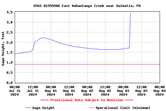
I got up this morning and usually hear the creek if it's low. But this morning I didn't hear the creek. So I looked down at the creek and seen that it has risen quite a bit since last evening (2ft) Wonder if we'll get heavy rain today to raise the creek even more? I only got .36 yesterday so it must have rained quite a bit more somewhere else to raise the creek. Nws says theres an elevated risk of excessive rainfall today.
-
1
-
-
2 hours ago, Jns2183 said:
Much more
 than the crap here. We will have to flood pillow out to get back to normal
Sent from my SM-G970U using Tapatalk
Don't flood Pillow out, you'll pay downstream.
-
Dewpoint 78.4 here and rain
-
At home. Picked up .10 rain overnight.

-
From our friend DT:
-
For the month of July I'm at 5.15in of rain. Feeling bless about that. Hopefully a lot more areas can get much needed rain the next few days.
-
5
-
-
13 minutes ago, Voyager said:
Thing with the rain last night was that I didn't see the heaviest of it. I was coming up from Allentown and was seeing lightning to my northwest. I then got to our fuel location, which is 10 miles south of Tamaqua, and still dry. Checked my station while fueling, and I had about 1.25". Got to our shop which is southeast of Tamaqua, parked the truck, did paperwork, and felt the first drops while walking to the Jeep. Drove home in a few downpours, but missed the brunt of it as the super heavy stuff trained right through Tamaqua. Areas near my work location didn't get half what I got at home.
So are the days of the Tamaqua split over? Has the curse been finally broken?
-
Seen got .61 at home. Nice thunderstorm out over the ocean this morning. Always nice watching a thunderstorm out over the ocean especially at night.
-
3
-
-
37 minutes ago, Bubbler86 said:
Sounds like maybe it is a good way to end the weekend vs. feeling down. Lot's of people get down on Sunday evening.
Is this what you mean by "get down on it"? Or are you talking bout "getting down"?
-
 2
2
-
-
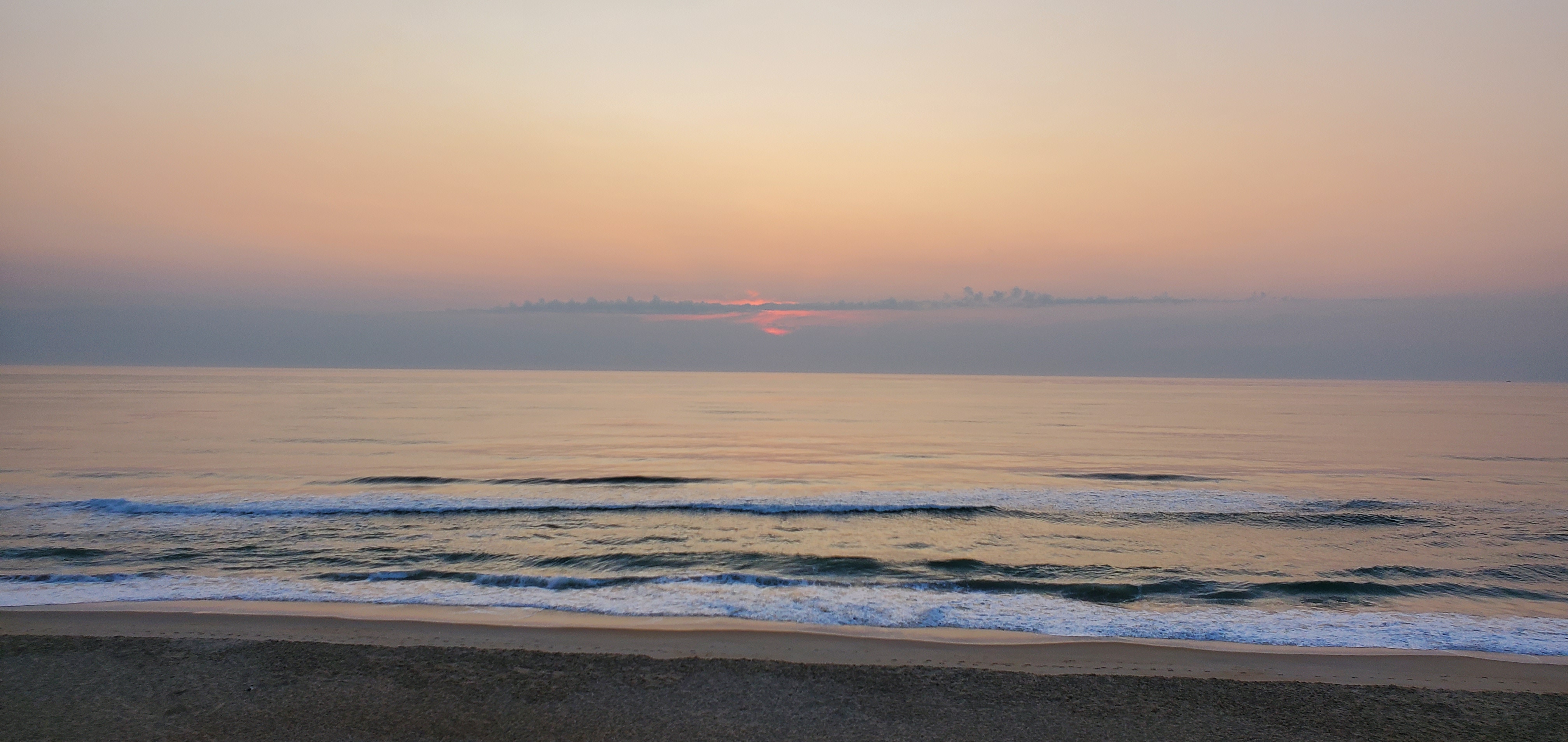
The wife and I are in Nags Head for a few days. Nice weather here. But maybe in a week or so it might not be so nice weather wise.
-
1
-
-
My view this morning.

-
5
-
-
14 minutes ago, mitchnick said:
Funny you mention this, I check this site almost every day. Has some pretty cool info. Just put in your zip code for your back yard.
https://www.timeanddate.com/sun/@4558482
I have that site on my phone.
-
3
-
-
4 minutes ago, Bubbler86 said:
Sorry for your and @Voyager loss. How did the light switch magic act go?
I wasn't up to the carnival, I was up for the parade on Tuesday and the parade was half hour long.
-
1
-
-
Summer is fading faster then we think. We have lost 39 min. Of daylight since the summer solstice.
-
 1
1
-
-
14 minutes ago, Bubbler86 said:
54 this Am. Perfect temps for a good Ninja soak. Saw a jogger go by dressed like it was winter.
54 here as well.
-
1
-
-
-
15 minutes ago, Bubbler86 said:
Wow, Impressive. 40's near Dubois. 62 for the low here. Windows open.

Blizz will be happy to see the downward trend in temps...snow maps won't be far behind.
-
3
-
1
-
-
55 this morning.
-
1
-


Central Pa. Summer 2024
in Upstate New York/Pennsylvania
Posted
.01 rain today.