

mahantango#1
-
Posts
3,278 -
Joined
-
Last visited
Content Type
Profiles
Blogs
Forums
American Weather
Media Demo
Store
Gallery
Posts posted by mahantango#1
-
-
Sounds like a lot of damage from that storm this morning in Harrisburg.
-
7 minutes ago, Atomixwx said:
Thank you for not using the image of the index card game. I would have had to come throw you through a window lol
That sounds like a penalty to me.
-
3 minutes ago, Bubbler86 said:
I had 1.8" last evening and it had not rained much until this AM. The storm went WAAAAAAAY west of me....dry slotted in some manner. I am fine with what I have. I scored big in the pregame with the 1.8".
It's good to have you back in the game!
-
 2
2
-
-
Just now, Bubbler86 said:
It is pouring. Looking at around 2.5" event total now. It did not rain at all after last evening...until now.
You must live in some restricted rain zone controlled by DT or the government. Your only allowed to get precipitation when they say. I thought you'd have more till morning.
-
1.09 rain since yesterday.
Creek hasn't risen very much.

-
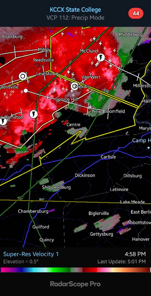
TORNADO WATCH OUTLINE UPDATE FOR WT 616
NWS STORM PREDICTION CENTER NORMAN OK
615 AM EDT FRI AUG 9 2024

TORNADO WATCH 616 IS IN EFFECT UNTIL 200 PM EDT FOR THE
 FOLLOWING LOCATIONS

PAC001-011-015-017-025-029-037-041-043-045-067-069-071-075-077-
079-081-089-091-093-095-097-099-101-103-107-109-113-115-119-127-
131-133-091800-
/O.NEW.KWNS.TO.A.0616.240809T1015Z-240809T1800Z/

PA
.    PENNSYLVANIA COUNTIES INCLUDED ARE

ADAMS                BERKS               BRADFORD
BUCKS                CARBON              CHESTER
COLUMBIA             CUMBERLAND          DAUPHIN
DELAWARE             JUNIATA             LACKAWANNA
LANCASTER            LEBANON             LEHIGH
LUZERNE              LYCOMING            MONROE
MONTGOMERY           MONTOUR             NORTHAMPTON
NORTHUMBERLAND       PERRY               PHILADELPHIA
PIKE                 SCHUYLKILL          SNYDER
SULLIVAN             SUSQUEHANNA         UNION
WAYNE                WYOMING             YORK
$$
-
.16 rain so far today.
-
Just now, Voyager said:
I'm still on the outside looking in...

Bring your tanker down here, I'm sure you'll be able to fill it up.
-
I see they expended the Flood watch. To put some counties on the east side of the Susquehanna River.
-
11 minutes ago, Bubbler86 said:
He denied me water per his post. He was hoarding and said something about "us skooks need to take care of skooks first"
I'm disappointed. I was looking forward to Voyager doing a video of him opening that back valve on the tanker and emptying the entire tanker of 8000 gallons of water in your yard.
-
2
-
-
9 minutes ago, Bubbler86 said:
Yes, it has been a soaker. Counting last evening there has been around 1.2". Ninja watering may be done for the year if the GFS/GEFS has any clue about much of the rest of August. A lot of rain and little in the way of heat.
.02 here yesterday. Glad your getting rain. I hope it's not too late to cancel your Voyager delivery of water.
-
1
-
-
29 minutes ago, Bubbler86 said:
About .6-.65.
Sounds like you'll need a load or two of water from Voyager to catch up to almost everyone else.
-
1
-
-
My creek this morning, not bad. So the Mahantango Creek watershed area east of me didn't get the rain I got last evening. But it's muddy nonetheless.
Most recent instantaneous value: 2.57 08-07-2024 06:00 EDT

-
1.56 rain yesterday
1.93 for the month
6.05 rain the last 30 days
31.65 rain for the year* but my internet was down for a few days in May so i'm missing about .50
-
 4
4
-
-
-
Are we gonna get what's in western PA. Or will that fall apart till it gets to the Susquehanna Valley?
-
My rain rate was 4.51 in hr. In that thunderstorm. 1.25 fell. Currently up to 1.41 for the day.
-
1
-
-
My rain rate was a bit ago 4.51 in hr.
-
2
-
-
Thunderstorm Warning
PAC043-067-075-097-099-107-109-062200-
/O.NEW.KCTP.SV.W.0149.240806T2123Z-240806T2200Z/
BULLETIN - IMMEDIATE BROADCAST REQUESTED
Severe Thunderstorm Warning
National Weather Service State College PA
523 PM EDT Tue Aug 6 2024
The National Weather Service in State College PA has issued a
* Severe Thunderstorm Warning for...
Northern Dauphin County in south central Pennsylvania...
Northeastern Juniata County in central Pennsylvania...
Northwestern Lebanon County in south central Pennsylvania...
Southwestern Northumberland County in central Pennsylvania...
Northeastern Perry County in south central Pennsylvania...
Southwestern Schuylkill County in central Pennsylvania...
Southeastern Snyder County in central Pennsylvania...
* Until 600 PM EDT.
* At 520 PM EDT, a severe thunderstorm was located over Millersburg,
moving east at 30 mph.
HAZARD...60 mph wind gusts and quarter size hail.
SOURCE...Radar indicated.
IMPACT...Hail damage to vehicles is expected. Expect wind damage
to roofs, siding, and trees.
* Locations impacted include...
Valley View, Millersburg, Lykens, Elizabethville, Williamstown,
Tower City, Port Trevorton, New Buffalo, Klingerstown, Leck Kill,
Urban, and Dehart Dam.
This includes Interstate 81 from mile markers 78 to 83.
PRECAUTIONARY/PREPAREDNESS ACTIONS...
Stay inside a well built structure and keep away from windows.
To report severe weather, contact your nearest law enforcement
agency. They will send your report to the National Weather Service
office in State College PA.
-
2 minutes ago, Jns2183 said:
Jealous

Sent from my SM-G970U using Tapatalk
That's headed my way!
-
Had .15 rain earlier. Then sun came out with a dewpoint of 80.
-
Is it me, or are some of the models trending a little higher on precipitation?
-
1 minute ago, Voyager said:
From Walt Drag in the NYC forum. If any of this even comes true, and I'm not sure of the timing of Debby's remnants, it's going to be ugly for some folks. The fact that Drag kind of agrees with this scenario ( highly respect his met skills) speaks volumes to the potential magnitude of this event...
2011 in September had a similar set up before Lee came . We were in a drought and we had thunderstorms roll through that dumped over 2 in. of rain. WE were at Kipona in Harrisburg to see the fireworks. Well you could see the lightning in the distance that seemed to be nonstop. Harrisburg said they will start the fireworks early because some of those storms were severe with heavy rain. On the way home we got caught in those storms in Dauphin. It was very hard to see driving with the intense rain coming down. I remember the creek was very low at that time. I remember the creek was high the day after those thunderstorms rolled through then a few days later Lee rolled in...the rest is history. So I wonder if the same thing will happen again. I hope not but anything is possible.
-
4 minutes ago, Voyager said:
I just woke up, but I finally, just NOW, saw what you did there...

She'd have made a great 'cane to do the Gulf up into Texas, that track to the metroplex. The innuendos would have been off the charts.
It took you awhile!
-
2
-


Central Pa. Summer 2024
in Upstate New York/Pennsylvania
Posted
Flood Warning National Weather Service State College PA 834 AM EDT Fri Aug 9 2024 PAC001-041-043-067-097-099-109-133-091530- /O.NEW.KCTP.FA.W.0007.240809T1234Z-240809T1530Z/ /00000.0.ER.000000T0000Z.000000T0000Z.000000T0000Z.OO/ Adams PA-Cumberland PA-Dauphin PA-Juniata PA-Northumberland PA- Perry PA-Snyder PA-York PA- 834 AM EDT Fri Aug 9 2024 ...FLOOD WARNING IN EFFECT UNTIL 1130 AM EDT THIS MORNING... * WHAT...Flooding caused by excessive rainfall is expected. * WHERE...A portion of central Pennsylvania, including the following counties, Adams, Cumberland, Dauphin, Juniata, Northumberland, Perry, Snyder and York. * WHEN...Until 1130 AM EDT. * IMPACTS...Flooding of rivers, creeks, streams, and other low-lying and flood-prone locations is imminent or occurring. * ADDITIONAL DETAILS... - At 833 AM EDT, Doppler radar indicated heavy rain returning to the area. Flooding is ongoing or expected to begin shortly in the warned area. Between 1.5 and 3.5 inches of rain have fallen. - Some locations that will experience flooding include... Harrisburg, Carlisle, Lower Allen, Hanover, Colonial Park, Weigelstown, Sunbury, Progress, Mechanicsburg, Camp Hill, Gettysburg, New Cumberland, Parkville, Linglestown, Enola, Steelton, Selinsgrove, Lemoyne, Northumberland and Hampton. - http://www.weather.gov/safety/flood PRECAUTIONARY/PREPAREDNESS ACTIONS... Turn around, don`t drown when encountering flooded roads. Most flood deaths occur in vehicles. && LAT...LON 4084 7718 4087 7706 4086 7702 4088 7696 4088 7681 4089 7681 4089 7678 4042 7677 3972 7678 3972 7724 4013 7723 4057 7732 $$ Evanego