

mahantango#1
-
Posts
3,942 -
Joined
-
Last visited
Content Type
Profiles
Blogs
Forums
American Weather
Media Demo
Store
Gallery
Everything posted by mahantango#1
-

Central PA - Winter 2021/2022
mahantango#1 replied to Bubbler86's topic in Upstate New York/Pennsylvania
My NWS forecast low Friday night is -2. Brr! -
Central PA - Winter 2021/2022
mahantango#1 replied to Bubbler86's topic in Upstate New York/Pennsylvania
Snowing here abut a half inch, everything covered temp 31. -
Central PA - Winter 2021/2022
mahantango#1 replied to Bubbler86's topic in Upstate New York/Pennsylvania
raining here and on top of the cold ground it is ice, temp 34 it was 29@900pm last night. So it went up during the night. -
Central PA - Winter 2021/2022
mahantango#1 replied to Bubbler86's topic in Upstate New York/Pennsylvania
I'm in it for the longhaul. -
Central PA - Winter 2021/2022
mahantango#1 replied to Bubbler86's topic in Upstate New York/Pennsylvania
To me it's the wind that makes winter not so enjoyable and add wind chill to the mix...ugh. But i'll have to enjoy the month and and a half of winter that will be upon us. At least the sun is rising earlier and setting later which makes it a little easier to cope, -
Central PA - Winter 2021/2022
mahantango#1 replied to Bubbler86's topic in Upstate New York/Pennsylvania
Winter is here looking forward to spring at this point. But I think winter has other ideas. -
Central PA - Winter 2021/2022
mahantango#1 replied to Bubbler86's topic in Upstate New York/Pennsylvania
Do you think this will come a little more north more then is modeled? -
Central PA - Winter 2021/2022
mahantango#1 replied to Bubbler86's topic in Upstate New York/Pennsylvania
According to my weather station with the snow that melted and the rain I had 1.16 liquid equivalent. Had 3 in of snow before the sleet showed up. -
Central PA - Winter 2021/2022
mahantango#1 replied to Bubbler86's topic in Upstate New York/Pennsylvania
27 here -
Central PA - Winter 2021/2022
mahantango#1 replied to Bubbler86's topic in Upstate New York/Pennsylvania
I have my doubts also! -
Central PA - Winter 2021/2022
mahantango#1 replied to Bubbler86's topic in Upstate New York/Pennsylvania
S&S storm chasing on Facebook -
Central PA - Winter 2021/2022
mahantango#1 replied to Bubbler86's topic in Upstate New York/Pennsylvania
About 40 min ago. -
Central PA - Winter 2021/2022
mahantango#1 replied to Bubbler86's topic in Upstate New York/Pennsylvania
Within the last hour I believe -
Central PA - Winter 2021/2022
mahantango#1 replied to Bubbler86's topic in Upstate New York/Pennsylvania
Good Ole S&S forecast!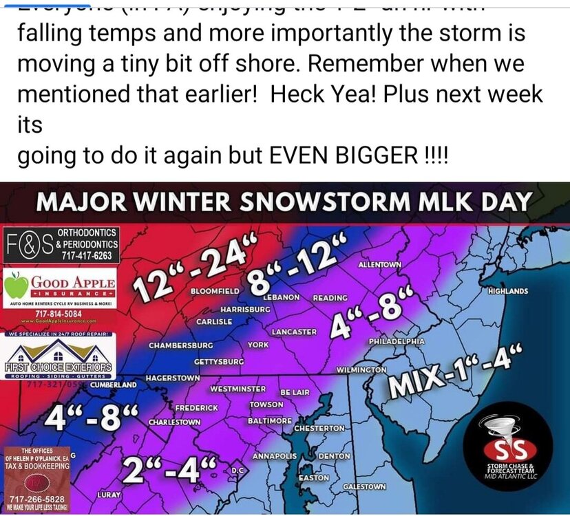
-
Central PA - Winter 2021/2022
mahantango#1 replied to Bubbler86's topic in Upstate New York/Pennsylvania
WHTM 27 just said another 2-3 hrs of snow before changeover. -
Central PA - Winter 2021/2022
mahantango#1 replied to Bubbler86's topic in Upstate New York/Pennsylvania
2 in here. -
Central PA - Winter 2021/2022
mahantango#1 replied to Bubbler86's topic in Upstate New York/Pennsylvania
Holding at 22 for 2 hours. -
Central PA - Winter 2021/2022
mahantango#1 replied to Bubbler86's topic in Upstate New York/Pennsylvania
Snow has commenced in Pillow area. -
Central PA - Winter 2021/2022
mahantango#1 replied to Bubbler86's topic in Upstate New York/Pennsylvania
Anyone see that S&S forecasting update they are going way out on the limb. -
Central PA - Winter 2021/2022
mahantango#1 replied to Bubbler86's topic in Upstate New York/Pennsylvania
Temp 20 dp 12 @1230pm -
Central PA - Winter 2021/2022
mahantango#1 replied to Bubbler86's topic in Upstate New York/Pennsylvania
From HenryMargusity this morning: The storm is underway and has overachieved in many areas of Arkansas into Tennessee and Mississippi. Snowfall has been over 7 inches in many locations and it’s still snowing hard across Tennessee into parts of Mississippi. Snow is also heavy across the western Carolina’s with ice also heavy in many areas of the Carolina’s this morning. Severe storms including tornadoes are moving across south Florida where SPC took a major bust on the severe weather potential. The surface map shows that low pressure is developing across southern Georgia and a reflection of low with the upper level system is back over Mississippi. With the wedge of cold air so entrenched, I think the low will have to go toward the coast despite the models saying that the low center is going to attack the cold and just ride through it warming everyone up above freezing. We have to see just how much that cold air will hold it’s ground as the low comes up. Heavy snow with rates of 1 inch per hour will come north up the mountains today into this evening. We may have a few hours of snow evaporating due to the dryness of the air. Heavy snow will move into western PA, NY, Northeast and Ontario tonight and last into Monday morning. These areas will see 12 inches perhaps more snow due to high ratios. Next weekend, we may have to go through this all over again. -
Central PA - Winter 2021/2022
mahantango#1 replied to Bubbler86's topic in Upstate New York/Pennsylvania
Just wondering if the low level will hold on a while longer then forecast. Sometimes models are too fast on eroding it. But what do I know. -
Central PA - Winter 2021/2022
mahantango#1 replied to Bubbler86's topic in Upstate New York/Pennsylvania
I guess the beginning of the kiss of death for snow lovers. Maybe with each passing hour till we get to go time. HHHr wont have any for the burg. -
Central PA - Winter 2021/2022
mahantango#1 replied to Bubbler86's topic in Upstate New York/Pennsylvania
Even with temps jumping into the 30s very early tomorrow morning, hard not to believe there wont be problems on the roads with it being below freezing 48 hours prior to this event. -
Central PA - Winter 2021/2022
mahantango#1 replied to Bubbler86's topic in Upstate New York/Pennsylvania
1 here


