

mahantango#1
-
Posts
4,243 -
Joined
-
Last visited
Content Type
Profiles
Blogs
Forums
American Weather
Media Demo
Store
Gallery
Posts posted by mahantango#1
-
-
The breeze started an pushed the temp to 49 from 38 all within an hour
-
 1
1
-
-
6 minutes ago, Bubbler86 said:
It is already 54 here. After the torch started off timidly Mon and Tue, it is kicking in full gear now. I would expect a 70 reading or two with those panels.
Wow only 38 here.
-
43 minutes ago, anotherman said:
Saw a honeybee today and smelled the ramps coming up in the woods. By my estimation, we are a full month ahead of schedule, if not more.Honeybees will come out from the hive during warm spells. They wer out in the beginning of January when it was warm. I have 1 hive of honeybees.
-
 2
2
-
-
Some pics showed up on my Facebook from 5 years ago. that was any icy mess all ice under that snow. Maybe that should make the snow lovers reminisce of what it could have been this winter.


-
4
-
-
3 minutes ago, Blizzard of 93 said:
The 6z GFS was close for the LSV this weekend. I think a low taking this track from NC to the DelMarVa would have more precip in general on the northwest side.


Everything seems to be against us this winter. Even when it starts looking good for a storm with potential, somehow some way it just seem to go away or misses us. Maybe we should think about spring, then maybe, just maybe we'll get pummeled by a storm thats forecast to miss us.
-
!st day of rain for the month last eve. But not even enough to register in the guage...just enough to wet the ground.
-
1
-
-
18 this morning...totally unexpected.
-
2
-
-
1 minute ago, Bubbler86 said:
33 here this Am. Lots of radar returns overnight in the Eastern LSV? Anyone see snow? May not have reached the ground.
30 here nothing here. Zero precip for the month here, bucking the trend from the previous 3 months.
-
1
-
-
8 was the low this morning
-
16 minutes ago, Blizzard of 93 said:
Lots of time to sort out details with track, precip type & timing, but hopefully we get a favorable trend this time when we get to 5 days out and under.
Maybe February will deliver, one thing I noticed is this is the first month since November we didn't start out above normal with rain. So maybe the pattern is changing...somewhat.
-
1
-
-
Winds have gotten stronger the last hour.
-
3 minutes ago, Bubbler86 said:
Just your basic -99 Wind Chill and 130MPH Gust day.
Crazy, I wouldn't want to be up there in the winter. Might be nice to experience it for a few minutes, but that would be enough for me.
-
1
-
-
Mount Washington New Hampshire forecast from NWS:
https://forecast.weather.gov/MapClick.php?lat=44.27049000000005&lon=-71.30345999999997#.Y90K43bMKXI
TodayMostly sunny and cold, with a temperature falling to around -39 by 5pm. Very windy, with a northwest wind around 75 mph, with gusts as high as 95 mph.TonightPartly cloudy, with a low around -46. Wind chill values as low as -99. Very windy, with a northwest wind 75 to 85 mph increasing to 85 to 95 mph after midnight. Winds could gust as high as 120 mph.SaturdaySunny and cold, with a high near -10. Very windy, with a northwest wind 90 to 100 mph decreasing to 65 to 75 mph. Winds could gust as high as 130 mph.Saturday NightIncreasing clouds, with a low around -16. Wind chill values as low as -52. Very windy, with a west wind 50 to 55 mph becoming south after midnight. Winds could gust as high as 70 mph.SundayA 30 percent chance of snow showers before 1pm. Cloudy, with a high near 20. Very windy, with a south wind 60 to 65 mph, with gusts as high as 80 mph.-
1
-
1
-
 2
2
-
-
Just now, canderson said:
So many friends are losing trees. It’s bad stuff.
If we had something like that here it would be a disaster.
-
Surprising wind is not to bad so far unless in increases later on.
-
11 minutes ago, Blizzard of 93 said:
As @Bubbler86mentioned, the 0z GFS had a snow chance on Super Bowl Sunday night.
It got me dreaming a little dream of Victory & Snow….


-
1
-
 1
1
-
-
Have a friend that lives in Wemberly Texas he has these ice pics from the storm the other day.


-
8
-
1
-
-
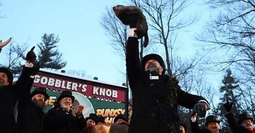
Just now, Bubbler86 said:
All the people that cancelled receive their comeuppance from a furry critter. LOL
I wonder if Blizz was out there at Gobblers Knob shining a spotlight so Phil would see his shadow?
-
2
-
-
-
10 minutes ago, Atomixwx said:
Cancel the motherfucker now.
Sent from my motorola edge 5G UW (2021) using Tapatalk

-
2
-
-
6 more weeks of this so called winter
-
2
-
-
-
Dreading the canderson unsecured garbage can. loose shingle winds later this week.
-
1
-
-
Low was 23, and with the sun and a bit of a breeze, the temperature is not in a hurry of going up quick.


Central PA Winter 2022/2023
in Upstate New York/Pennsylvania
Posted