Met1985
-
Posts
16,870 -
Joined
-
Last visited
Content Type
Profiles
Blogs
Forums
American Weather
Media Demo
Store
Gallery
Everything posted by Met1985
-
I'm watching this really close. I think this is the start of everything this afternoon. Sent from my SM-G998U using Tapatalk
-
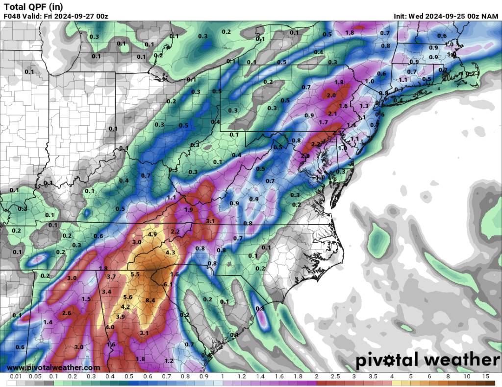
Huge increase on the NAM from 6z.
-
Yeah looks like it's going to miss the Yucatan which will only help this thing become a monster. It's already a very large storm.
-
Yeah I just read that. Not good at all. Looks like the original forecast to miss the Yucatan will turn out true. This is good news for strengthening but bad news for us. The bigger, the meaner, the more this thing grows the worst is will possibly be for us. Again just my observation.
-
I actually think I bit of a west jog would be really bad for us because it puts us on the NW side of Helene. We get the brunt of anything that is still with her and it drags that train of moisture right through WNC. Just my opinion.
-
No kidding! That's impressive. I've been lucky to only get .25 inches this week. I've been re-hanging fallen gutter today...
-
I hope all these modeled precipitation outputs are wrong or it decides to change direction on us. Even in a mild drought that's way to much rainfall all at once. Here's to open it's not historic lol.
-
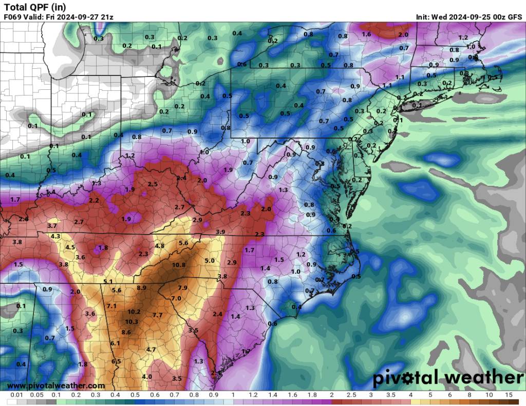
00z GFS... This is historical for this type of event... Sent from my SM-G998U using Tapatalk

-
Holy sheet!
-
@Rainforrestyou better get your john boat ready...
-
Just freaking pulverized. Sent from my SM-G998U using Tapatalk
.thumb.jpg.e80dcb4a98ac33841735b7480f32e4bc.jpg)
-
We are keeping a very close eye on that here in WNC. Even before Helene gets here we are expecting some 4 to 6 inches and some have already gotten close to 3 inches this week already. This could be historical for us.
-
About the same but crazy right before Helene. 00z NAM Sent from my SM-G998U using Tapatalk

-
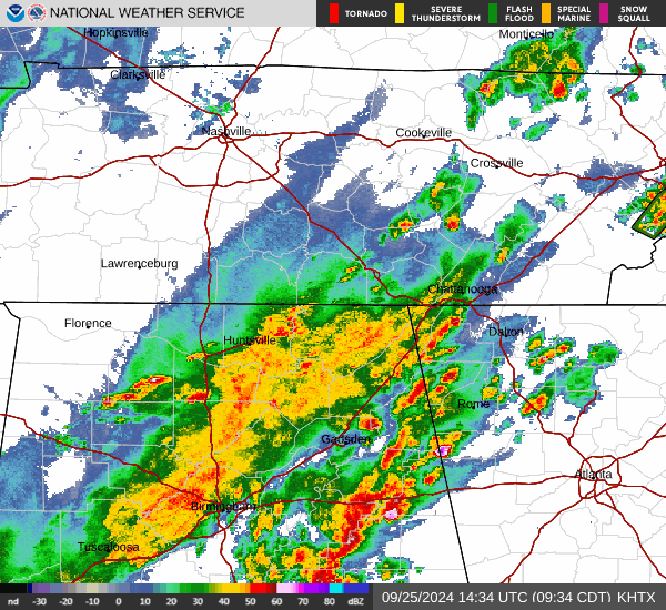
Yeah I noticed you have training going right over you tonight. Not good at all.
-

Summer-Fall 2024 Weather Disco Med/Long Range
Met1985 replied to John1122's topic in Tennessee Valley
Yeah this is exactly what we are worried about. I talked in our thread about this being a historical event for us...- 688 replies
-
- 2
-

-

-
- heat
- thunderstorms
- (and 7 more)
-
Summer-Fall 2024 Weather Disco Med/Long Range
Met1985 replied to John1122's topic in Tennessee Valley
I have not seen it. Go ahead and post it. We are keeping a very close eye in things over this side of the mountain. The trend is NOT our friend.- 688 replies
-
- 1
-
-
- heat
- thunderstorms
- (and 7 more)
-
Also from what I'm gathering from the main tropical thread is that this storm. Is going to be large scale in size. This isn't going to be an extremely compact storm but more of a beast of a storm.. That will help generate some wild weather here across the mountains.
-
Yeah the winds which we usually don't have to worry about seem worrisome currently. With a saturated ground and gusts 50 plus... That is a recipe for a lot of down trees.
-
I would if you want to get home in time.
-
Yeah I believe @GaWx has alluded to possible severe storms and Tornados as Helene runs her way through the SE and us. If she moves quickly and right over our area we could see some narly cells cross the area.
-
You are probably screwd....
-
Yeah no doubt about that and also a great assessment to the southern upslope factor.
-
Tomorrow morning is the time to batten down the hatches. Get your generator going and making sure you have flashlights, blankets, water, maybe a camp cooking stove, and possibly an alternative place to stay in case your power goes out for an extended period of time. Also if you live near a river or stream keep an eye out but do not wait until the last minute to leave your home. Also be sure you have an alternate plan for your animals. They are family so take care of them and keep them safe as well. Just be prepared and tune into here and the NWS because you know we are some of the best to keep up to date info at the first of hearing anything.
-
Yeah as shown currently this is going to be a historical event.. Not hyping but just looking at the data. Again any sudden change with this thing and that could greatly impact our area but so far all models have us as ground zero.
-
Things are going to go downhill from here on out.

.jpg.c5d75fd47f5b8806fa543fd2663dfe04.jpg)