Met1985
-
Posts
15,298 -
Joined
-
Last visited
Content Type
Profiles
Blogs
Forums
American Weather
Media Demo
Store
Gallery
Everything posted by Met1985
-

2023-2024 Fall/Winter Mountain Thread
Met1985 replied to The Alchemist's topic in Southeastern States
Temp down to 37 already. We are 3 degrees Colfer currently then we were last night at this time. -
No kidding! Two big plunges of cold air and some heavy mountain snow.
-
2023-2024 Fall/Winter Mountain Thread
Met1985 replied to The Alchemist's topic in Southeastern States
Not as cold as I thought it would be but we had a light breeze most of the night. Had a low of 35 with no frost except on top of the truck. Tonight will be our night to get a frost. -
2023-2024 Fall/Winter Mountain Thread
Met1985 replied to The Alchemist's topic in Southeastern States
Just a snapshot Sent from my SM-G998U using Tapatalk -
2023-2024 Fall/Winter Mountain Thread
Met1985 replied to The Alchemist's topic in Southeastern States
Good Lord the 6z went gang busters this morning! Sent from my SM-G998U using Tapatalk -
2023-2024 Fall/Winter Mountain Thread
Met1985 replied to The Alchemist's topic in Southeastern States
Yeah that is impressive for sure. Already down to 40 here. -
2023-2024 Fall/Winter Mountain Thread
Met1985 replied to The Alchemist's topic in Southeastern States
You still pretty breezy that way? -
2023-2024 Fall/Winter Mountain Thread
Met1985 replied to The Alchemist's topic in Southeastern States
Temp down to 45 already. -
2023-2024 Fall/Winter Mountain Thread
Met1985 replied to The Alchemist's topic in Southeastern States
Yeah really all the indices look very good. We have blocking over the top and a plus PNA. Yeah wind has picked up and we are at 44. This weather is so freaking refreshing. The leaves should really take off here in the next few weeks. -
2023-2024 Fall/Winter Mountain Thread
Met1985 replied to The Alchemist's topic in Southeastern States
Indices look good for this time of the year. Obviously they will adjust but it's nice seeing a plus PNA this early in the season. Sent from my SM-G998U using Tapatalk -
2023-2024 Fall/Winter Mountain Thread
Met1985 replied to The Alchemist's topic in Southeastern States
This would be record breaking for this time of the year. I don't think this will happen but the indices do look favorable especially in the second half of the month. Sent from my SM-G998U using Tapatalk
-
2023-2024 Fall/Winter Mountain Thread
Met1985 replied to The Alchemist's topic in Southeastern States
Had a great night of rainfall. Had several showers come through overnight. Picked up .70 inches of rainfall. Had a crisp morning this morning with a low and current temp of 45 degrees. Looks like a cold weekend on tap. This is refreshing for the first of October. -
2023-2024 Fall/Winter Mountain Thread
Met1985 replied to The Alchemist's topic in Southeastern States
FROST ADVISORY IN EFFECT FROM 2 AM TO 10 AM EDT SUNDAY... * WHAT...Temperatures as low as 33 will result in patchy frost formation. * WHERE...Portions of northeast Georgia, and the mountains and foothills of western North Carolina. * WHEN...From 2 AM to 10 AM EDT Sunday. It's going to get cold. -
You talking about this month or next Carver?
-
2023-2024 Fall/Winter Mountain Thread
Met1985 replied to The Alchemist's topic in Southeastern States
This would be a huge PNA spike positive. Sent from my SM-G998U using Tapatalk -
2023-2024 Fall/Winter Mountain Thread
Met1985 replied to The Alchemist's topic in Southeastern States
Well this weekend is going to be absolutely raw. So far I've got a high of 58 and 54 this weekend with lows in the low to mid 30s... -
2023-2024 Fall/Winter Mountain Thread
Met1985 replied to The Alchemist's topic in Southeastern States
Avery-Madison-Yancey-Mitchell-Swain-Haywood-Buncombe-Graham- Northern Jackson-Macon-Southern Jackson-Transylvania-Henderson- Caldwell Mountains-Burke Mountains-McDowell Mountains- 325 AM EDT Tue Oct 3 2023 This Hazardous Weather Outlook is for the mountains of western North Carolina. .DAY ONE...Today and tonight. Hazardous weather is not expected at this time. .DAYS TWO THROUGH SEVEN...Wednesday through Monday. Patchy frost will be possible in sheltered valley locations around daybreak Sunday. More widespread frost is possible across the mountains Sunday night into Monday morning. -
Hunter does a great job! We are glad to have him on the forum.
-
2023-2024 Fall/Winter Mountain Thread
Met1985 replied to The Alchemist's topic in Southeastern States
A nice cold morning this morning with a low of 46 degrees. -
2023-2024 Fall/Winter Mountain Thread
Met1985 replied to The Alchemist's topic in Southeastern States
Thank you! -
2023-2024 Fall/Winter Mountain Thread
Met1985 replied to The Alchemist's topic in Southeastern States
Nice! The big cool down this weekend looks to be legit. -
You have my vote. Just follow what we've done in the past. Just make a Fall/winter mountain thread ect, ect.
-
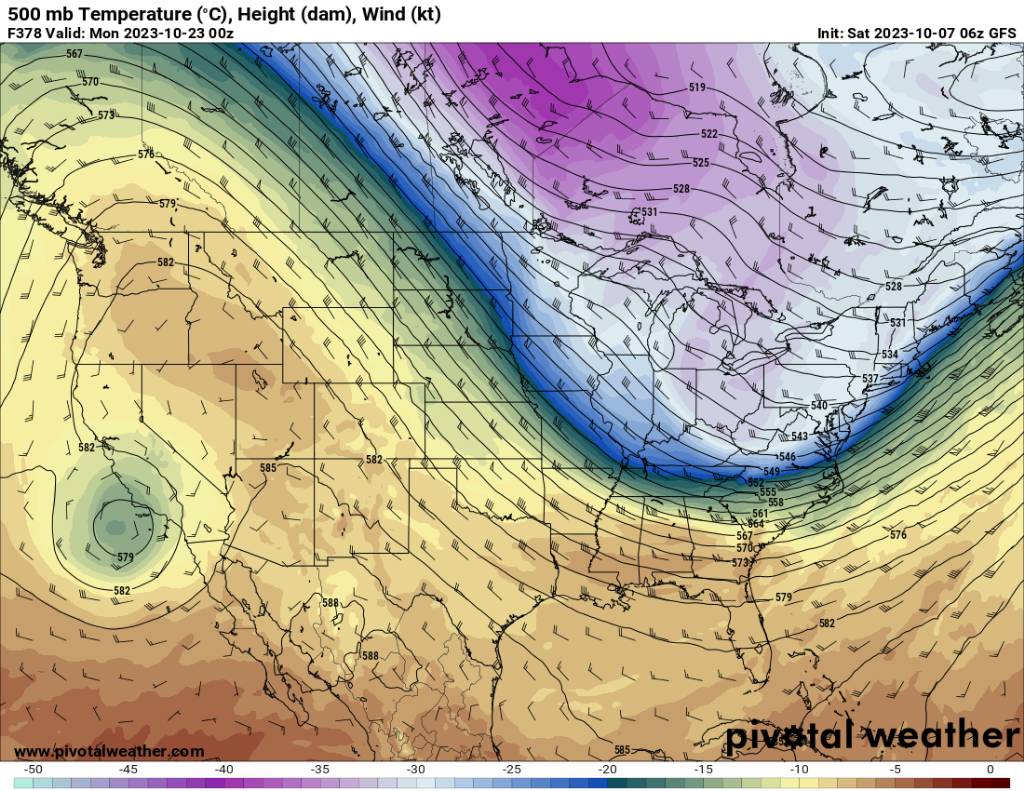
Euro getting on-board. Sent from my SM-G998U using Tapatalk
-
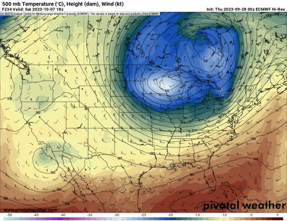
Day 10 but doable. Sent from my SM-G998U using Tapatalk
-
Also as of noted from Jeff and others that if we see a strong El Nino then we are literally toast. All we could hope for is a thread the needle event.