

Met1985
-
Posts
15,299 -
Joined
-
Last visited
Content Type
Profiles
Blogs
Forums
American Weather
Media Demo
Store
Gallery
Everything posted by Met1985
-

2023-2024 Fall/Winter Mountain Thread
Met1985 replied to The Alchemist's topic in Southeastern States
Down to 38 here but I suck at CAD. looking forward to the tornadoes lol. -
2023-2024 Fall/Winter Mountain Thread
Met1985 replied to The Alchemist's topic in Southeastern States
Flood watch issued for just about everyone in the mountains. -
Looks like a NINA pattern.
-
2023-2024 Fall/Winter Mountain Thread
Met1985 replied to The Alchemist's topic in Southeastern States
Yeah I think you are right. That and some high winds. Fun times. -
2023-2024 Fall/Winter Mountain Thread
Met1985 replied to The Alchemist's topic in Southeastern States
A beautiful cold morning with a low of 18. -
2023-2024 Fall/Winter Mountain Thread
Met1985 replied to The Alchemist's topic in Southeastern States
06z gefs doesn't agree with the op. Sent from my SM-G998U using Tapatalk.thumb.jpg.471126d870cbb9e757a749f6c236d86e.jpg)
.thumb.jpg.c696649f1844b9d27de7af1849f9d2a5.jpg)
.thumb.jpg.0673da2b808990baf2acec7434277b47.jpg)
-
2023-2024 Fall/Winter Mountain Thread
Met1985 replied to The Alchemist's topic in Southeastern States
00z eps Sent from my SM-G998U using Tapatalk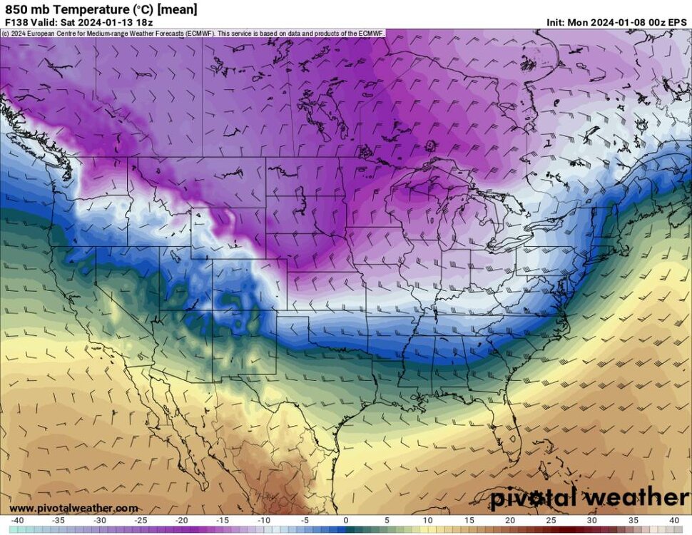
.thumb.jpg.80f16668d1b3150a6bd1e9c5d6179521.jpg)
-
2023-2024 Fall/Winter Mountain Thread
Met1985 replied to The Alchemist's topic in Southeastern States
The gfs changes every 6 hours also... I'm riding the Euro and eps. -
2023-2024 Fall/Winter Mountain Thread
Met1985 replied to The Alchemist's topic in Southeastern States
Yeah this is a beast of a system. Too bad it ain't going to be a blizzard. -
2023-2024 Fall/Winter Mountain Thread
Met1985 replied to The Alchemist's topic in Southeastern States
Avery-Yancey-Mitchell-Buncombe-Southern Jackson-Transylvania- Henderson-Caldwell Mountains-Burke Mountains-McDowell Mountains- Rutherford Mountains-Polk Mountains- Including the cities of Ingalls, Banner Elk, Newland, Swiss, Burnsville, Celo, Micaville, Ramseytown, Busick, Spruce Pine, Poplar, Asheville, Black Mountain, Candler, Wolf Mountain, Cashiers, Brevard, Cedar Mountain, Little River, Hendersonville, Fletcher, Dana, East Flat Rock, Tuxedo, Etowah, Jonas Ridge, Ashford, Woodlawn, Old Fort, Chimney Rock State Park, and Saluda 452 AM EST Mon Jan 8 2024 ...WINTER WEATHER ADVISORY IN EFFECT FROM 9 PM THIS EVENING TO 7 AM EST TUESDAY... * WHAT...Freezing rain expected. Total ice accumulations of around one tenth of an inch. Winds gusting as high as 55 mph. * WHERE...Portions of western North Carolina, mainly near the Blue Ridge Escarpment and the upper French Broad Valley. * WHEN...From 9 PM this evening to 7 AM EST Tuesday. -
2023-2024 Fall/Winter Mountain Thread
Met1985 replied to The Alchemist's topic in Southeastern States
This mornings 06z gfs rainfall.... Sent from my SM-G998U using Tapatalk.thumb.jpg.4c3f77a918c20d527bbafa968ad93224.jpg)
-
2023-2024 Fall/Winter Mountain Thread
Met1985 replied to The Alchemist's topic in Southeastern States
I know we are all hunting for snow but this system coming in tonight freaking means business. -
2023-2024 Fall/Winter Mountain Thread
Met1985 replied to The Alchemist's topic in Southeastern States
Including the cities of Robbinsville, Cullowhee, Bryson City, Ramseytown, Mars Hill, Waynesville, Spruce Pine, Stecoah, Walnut, Almond, Sylva, Cruso, Busick, Luada, Tuckasegee, Celo, Faust, Poplar, Canton, Hot Springs, Marshall, Micaville, Wesser, Luck, Alarka, Allenstand, Burnsville, Swiss, Cove Creek, and Waterville 357 AM EST Mon Jan 8 2024 ...HIGH WIND WARNING IN EFFECT FROM 7 PM THIS EVENING TO 7 PM EST TUESDAY ABOVE 3500 FEET... ...WIND ADVISORY IN EFFECT FROM 7 PM THIS EVENING TO 7 PM EST TUESDAY BELOW 3500 FEET... * WHAT...For the High Wind Warning above 3500 feet, southeast winds 25 to 35 mph with gusts up to 75 mph expected. For the Wind Advisory below 3500 feet, southeast winds 20 to 30 mph with gusts up to 55 mph expected. * WHERE...Graham, Haywood, Madison, Mitchell, Northern Jackson, Swain, and Yancey Counties. * WHEN...From 7 PM this evening to 7 PM EST Tuesday. -
2023-2024 Fall/Winter Mountain Thread
Met1985 replied to The Alchemist's topic in Southeastern States
Ashe-Alleghany NC-Watauga-Grayson-Carroll-Floyd- Including the cities of West Jefferson, Sparta, Boone, Independence, Whitetop, Troutdale, Volney, Galax, and Floyd 431 AM EST Mon Jan 8 2024 ...WINTER WEATHER ADVISORY IN EFFECT FROM MIDNIGHT TONIGHT TO 10 AM EST TUESDAY... * WHAT...A period of sleet and freezing rain is expected. Sleet accumulation is expected to be less than an inch. Icing from freezing rain may accumulate up to one tenth of an inch. -
2023-2024 Fall/Winter Mountain Thread
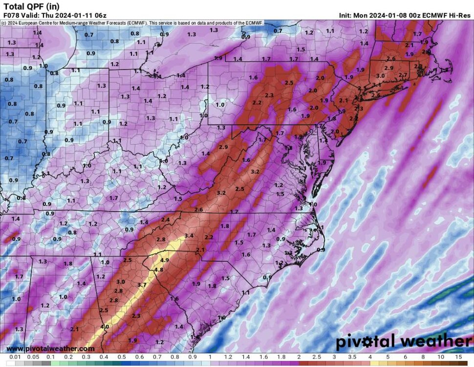
Met1985 replied to The Alchemist's topic in Southeastern States
A ton of rainfall coming this week and the models have been under performing with qpf... Sent from my SM-G998U using Tapatalk.thumb.jpg.03eb06cd9426ac4176a5ee1c61763ebe.jpg)
-
2023-2024 Fall/Winter Mountain Thread
Met1985 replied to The Alchemist's topic in Southeastern States
This is exactly what we need from the 00z euro. Sent from my SM-G998U using Tapatalk

.thumb.jpg.d12289f3225d7546a535821e2980f829.jpg)

-
2023-2024 Fall/Winter Mountain Thread
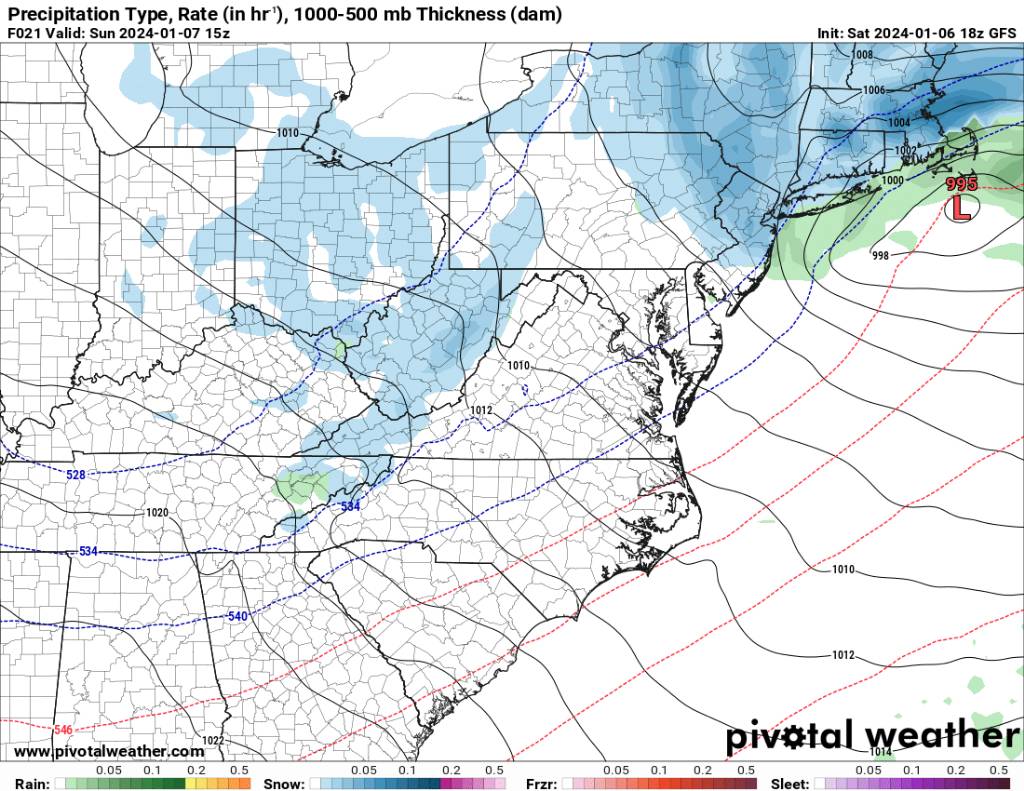
Met1985 replied to The Alchemist's topic in Southeastern States
Avery-Madison-Yancey-Mitchell-Swain-Haywood-Graham- Including the cities of Ingalls, Banner Elk, Newland, Faust, Mars Hill, Marshall, Walnut, Allenstand, Hot Springs, Luck, Swiss, Burnsville, Celo, Micaville, Ramseytown, Busick, Spruce Pine, Poplar, Alarka, Almond, Bryson City, Luada, Wesser, Waynesville, Waterville, Canton, Cruso, Cove Creek, Robbinsville, and Stecoah 635 PM EST Sat Jan 6 2024 ...LIGHT SNOW ACCUMULATIONS AND SLIPPERY CONDITIONS POSSIBLE IN THE NORTH CAROLINA MOUNTAINS OVERNIGHT INTO SUNDAY... Scattered to numerous snow showers will develop across the southern Appalachians starting late this evening and increasing in coverage overnight into Sunday morning. Locations above 3000 feet close to the Tennessee and North Carolina border could see accumulations up to an inch by Sunday morning. Locally higher amounts could occur, with 2 to 4 inches possible at higher ridge tops at and above 5000 feet. The snow showers will slowly taper off through late Sunday afternoon. -
2023-2024 Fall/Winter Mountain Thread
Met1985 replied to The Alchemist's topic in Southeastern States
Yeah I've already dropped to 36. That was fast especially after a high of 53. -
2023-2024 Fall/Winter Mountain Thread
Met1985 replied to The Alchemist's topic in Southeastern States
18z gfs showing some snow. Sent from my SM-G998U using Tapatalk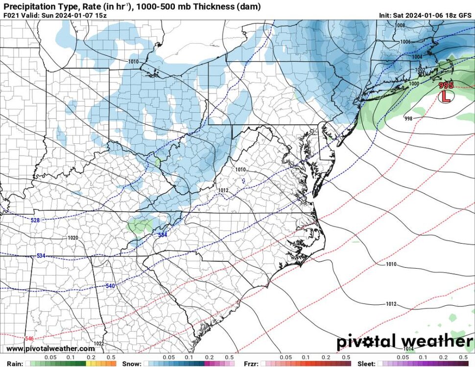
.thumb.jpg.ea4c2f18b74ea26f69a55e644fd45627.jpg)
.thumb.jpg.74be51e9b20c66be08ed38e5af2fae63.jpg)
-
2023-2024 Fall/Winter Mountain Thread
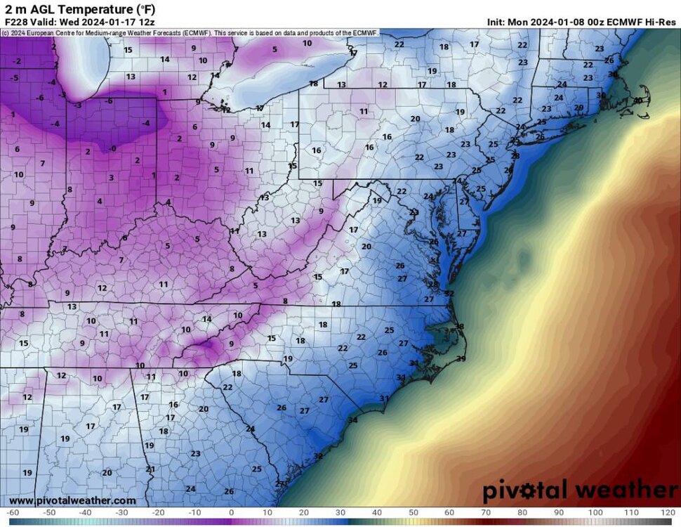
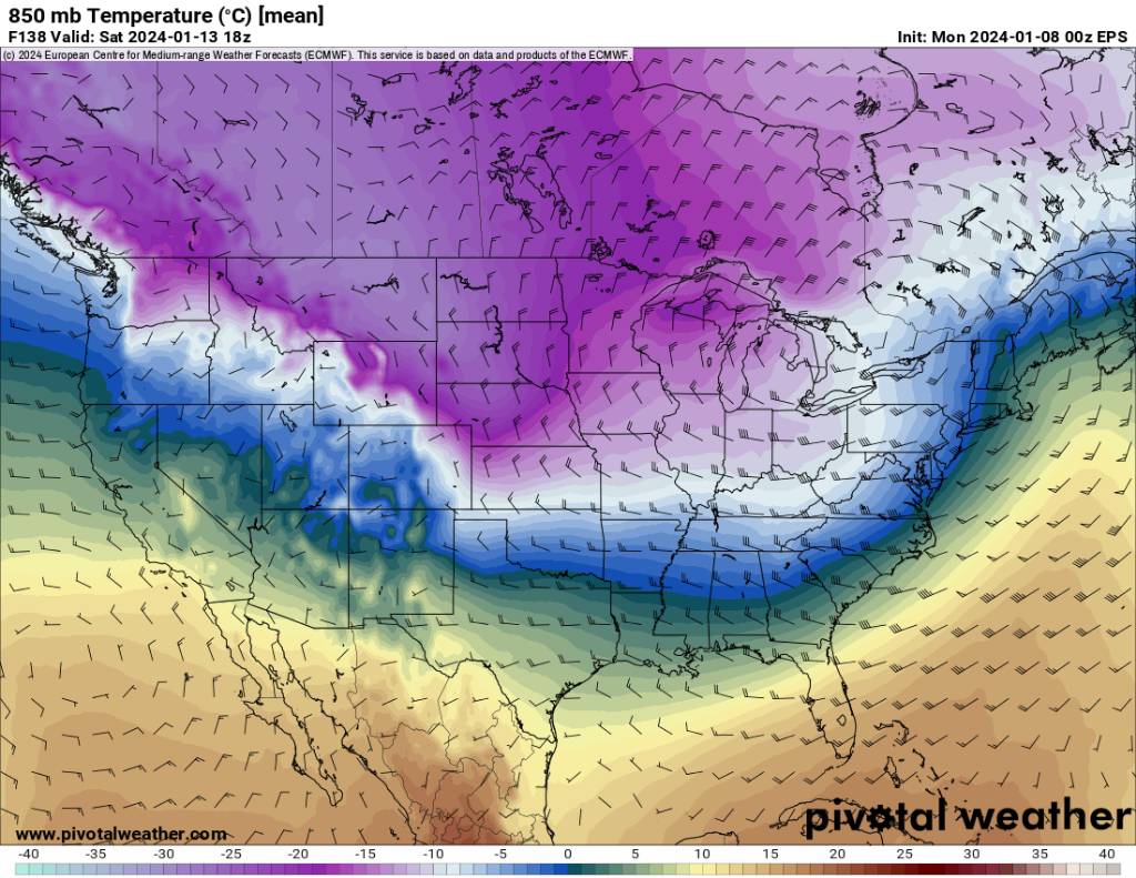
Met1985 replied to The Alchemist's topic in Southeastern States
18z gfs temps are extremely cold for several days. This is something we've not seen in a long time and are rare for a NINO. Sent from my SM-G998U using Tapatalk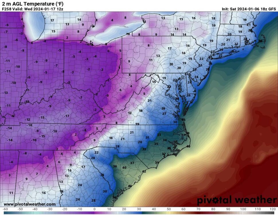
.thumb.jpg.7ff8b8e91eb86b18757aa7f261a4cc6c.jpg)
.thumb.jpg.2c55ee3fa444da4a51832bcf464c1928.jpg)
.thumb.jpg.94310151436cec83f7dd6515c7bf888f.jpg)
.thumb.jpg.a8872ffedca64099fbdab4d57174809c.jpg)
-
2023-2024 Fall/Winter Mountain Thread
Met1985 replied to The Alchemist's topic in Southeastern States
18z gfs coming in with the goods! This is POTENTIALLY what we could see later this month.... Sent from my SM-G998U using Tapatalk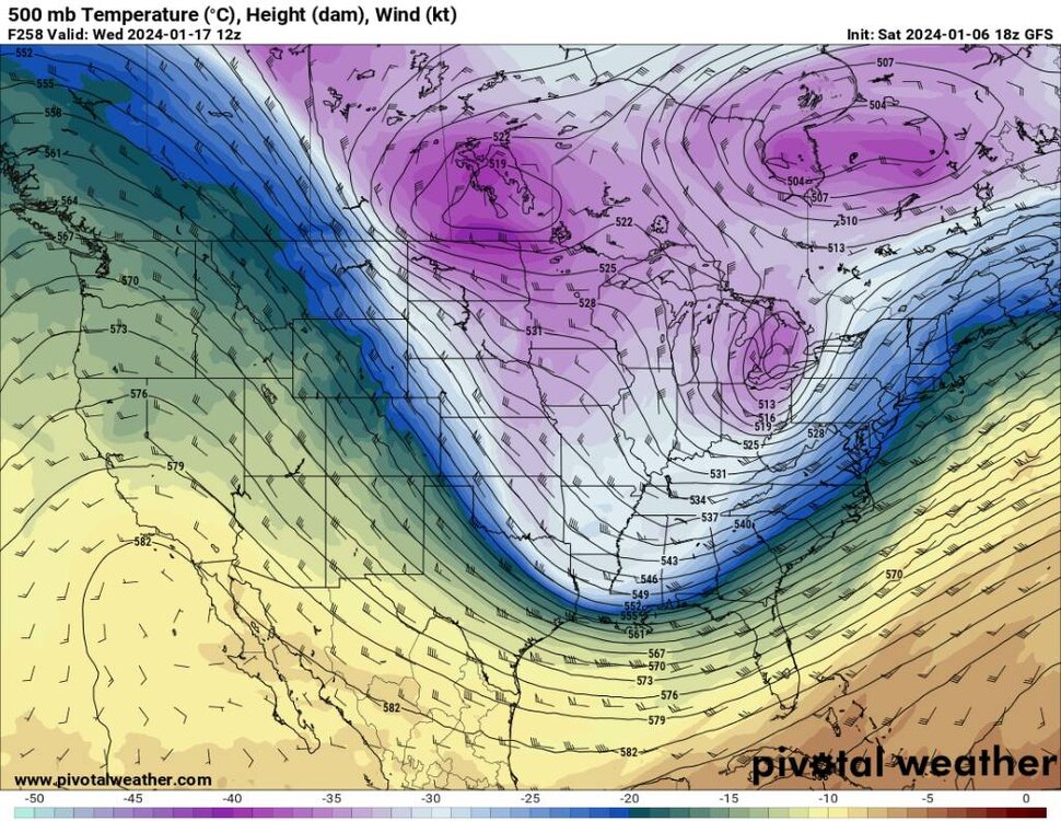
.thumb.jpg.3b8ee4b49ea4464c2923a0c1d1e661cc.jpg)
-
January Medium-Long Range Discussion
Met1985 replied to Holston_River_Rambler's topic in Tennessee Valley
I know on this side we've not had a ton if snow but we have had great conditions for snow making which is much better than what we had at this time last year. -
January Medium-Long Range Discussion
Met1985 replied to Holston_River_Rambler's topic in Tennessee Valley
Carver great stuff man..I've been honking that the Euro and the EPS are leading things in my opinion. -
January Medium-Long Range Discussion
Met1985 replied to Holston_River_Rambler's topic in Tennessee Valley
Yeah no kidding. Last year we hit negative 10 for a low on bare ground. Absolutely disgusting.... -
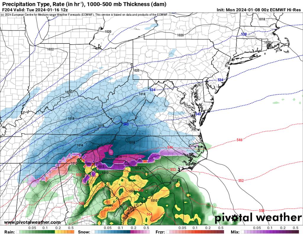
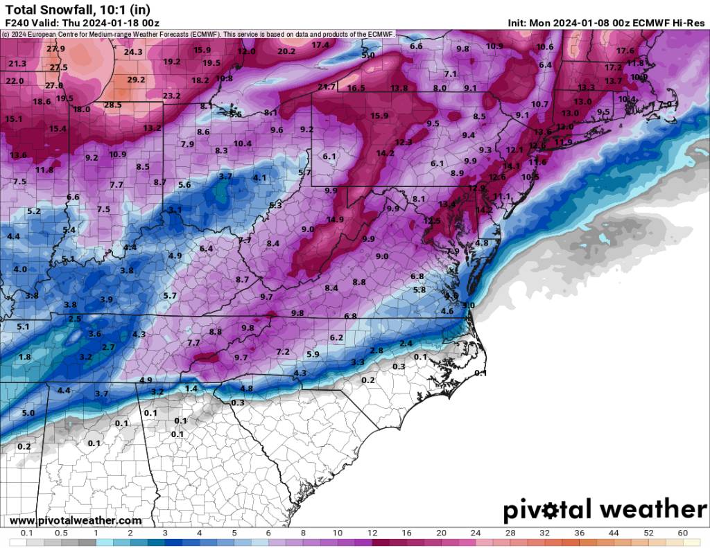
2023-2024 Fall/Winter Mountain Thread
Met1985 replied to The Alchemist's topic in Southeastern States
Yep the eps looks great. The pattern change on the eps is inside 10 days. Sent from my SM-G998U using Tapatalk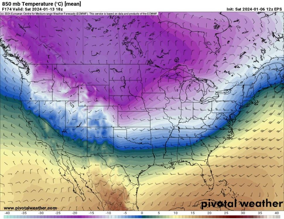
.thumb.jpg.51864e3ecce91e04bc77819f759aa7e4.jpg)
.thumb.jpg.e6d9ebcd657174fd3fae26b01a8bae57.jpg)


.jpg.0f489eedaf484b46b51c94a8c5ec78f2.jpg)
.jpg.05cdffdfe7eea10f24b24615ccbdaa99.jpg)
.jpg.88541b2c705982431b9c6e0e91ce169b.jpg)
.jpg.5f206290ff540732ad805cd87985e42c.jpg)
.jpg.28504174615954bb19846a1a7f4a35a2.jpg)
.jpg.4a3b84d97c6ed4eedd9823f93d85aa84.jpg)


.jpg.67fe80fe4c6f5aa7bbd5c941c8124d97.jpg)


.jpg.dd522f7b948b5516be6c6fdcc44956e5.jpg)
.jpg.f5608176340403230c0fc739469d8532.jpg)

.jpg.58028706d0d6f53780f25a983e6bb9eb.jpg)
.jpg.1b446cd45a9cc2ea4860a6dbfb4c030a.jpg)
.jpg.f638789075fa7fdc7d3eaa903a33d2d3.jpg)
.jpg.b84a9a504c81967f39cb90b739a95b97.jpg)

.jpg.953e6b2795223a75be2f817fcf0b044a.jpg)

.jpg.c90cab29ef9dc75ed6727c25e76def28.jpg)
.jpg.90201bce9d80a1689f22cd513a1898db.jpg)
