

Met1985
-
Posts
15,299 -
Joined
-
Last visited
Content Type
Profiles
Blogs
Forums
American Weather
Media Demo
Store
Gallery
Everything posted by Met1985
-

2023-2024 Fall/Winter Mountain Thread
Met1985 replied to The Alchemist's topic in Southeastern States
The NAM is going to be north again. -
2023-2024 Fall/Winter Mountain Thread
Met1985 replied to The Alchemist's topic in Southeastern States
That's significant for the SW mountains. -
2023-2024 Fall/Winter Mountain Thread
Met1985 replied to The Alchemist's topic in Southeastern States
Yeah I noticed it's a bit north as well but I'm not fretting. -
2023-2024 Fall/Winter Mountain Thread
Met1985 replied to The Alchemist's topic in Southeastern States
Son you know we're you at? You in the mountains thread son... -
2023-2024 Fall/Winter Mountain Thread
Met1985 replied to The Alchemist's topic in Southeastern States
Lol in one run the Euro takes the low from going through us all the way up into the Great Lakes... Yeah real consistent there Euro. Sent from my SM-G998U using Tapatalk.thumb.jpg.0caadacf03d07f46310d85c02390c34d.jpg)
-
2023-2024 Fall/Winter Mountain Thread
Met1985 replied to The Alchemist's topic in Southeastern States
A really weird run from the Euro. Doesn't really drop the hammer with the second system at all. I'm not worried. It will change again tonight. -
2023-2024 Fall/Winter Mountain Thread
Met1985 replied to The Alchemist's topic in Southeastern States
Unless I'm seeing things the second wave on the Euro is pretty nonexistent. -
January 15th-17th 2024 Arctic Blast/Snow Event
Met1985 replied to John1122's topic in Tennessee Valley
Carver you are a smart man. You hit the nail on the head when talking about the polar jet and suppression. This northern jet coming in is no joke next week. -
2023-2024 Fall/Winter Mountain Thread
Met1985 replied to The Alchemist's topic in Southeastern States
Why you worried? This is pretty much the same trajectory as we saw during our little snow this week. We will be fine. You'll do great in this flow. Franklin will do awesome as well. -
2023-2024 Fall/Winter Mountain Thread
Met1985 replied to The Alchemist's topic in Southeastern States
Well the days are ticking down. Basically 2 days from go time. -
2023-2024 Fall/Winter Mountain Thread
Met1985 replied to The Alchemist's topic in Southeastern States
Good run captain! -
2023-2024 Fall/Winter Mountain Thread
Met1985 replied to The Alchemist's topic in Southeastern States
Euro is looking decent for the first wave. Sent from my SM-G998U using Tapatalk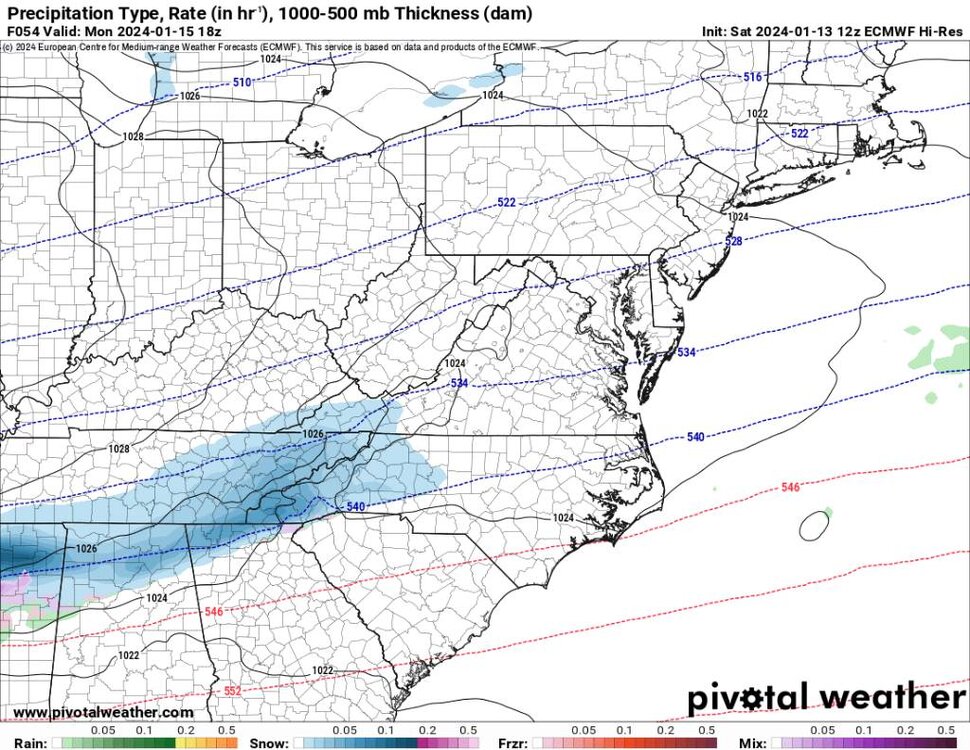
.thumb.jpg.8874e873df806743163734256916628c.jpg)
-
2023-2024 Fall/Winter Mountain Thread
Met1985 replied to The Alchemist's topic in Southeastern States
Temps are a bit colder after the second storm also. Again if there is that much snow around and on the ground these will be trending lower. Sent from my SM-G998U using Tapatalk
-
2023-2024 Fall/Winter Mountain Thread
Met1985 replied to The Alchemist's topic in Southeastern States
This could be a really good week for the whole viewing area. Sure at the current we aren't looking at a Miller A or a Miller B, but I'd take this look in a heartbeat. -
2023-2024 Fall/Winter Mountain Thread
Met1985 replied to The Alchemist's topic in Southeastern States
The second system snows go over 24 hours but you get the jist that next week could be big for a lot of mountain communities. Sent from my SM-G998U using Tapatalk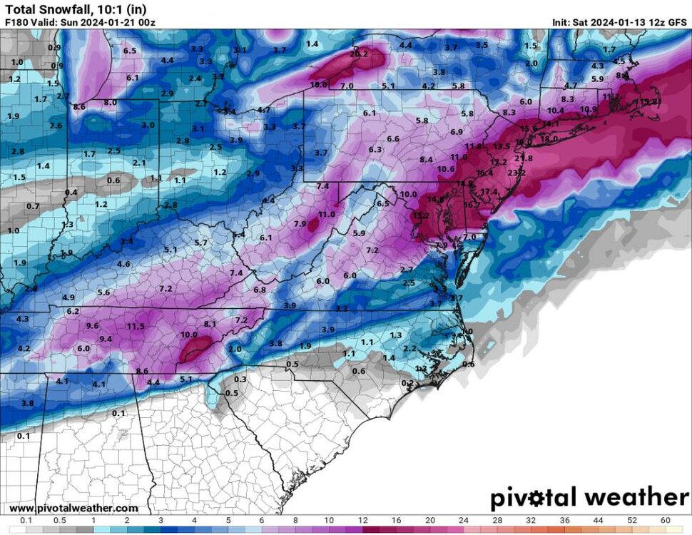
-
2023-2024 Fall/Winter Mountain Thread
Met1985 replied to The Alchemist's topic in Southeastern States
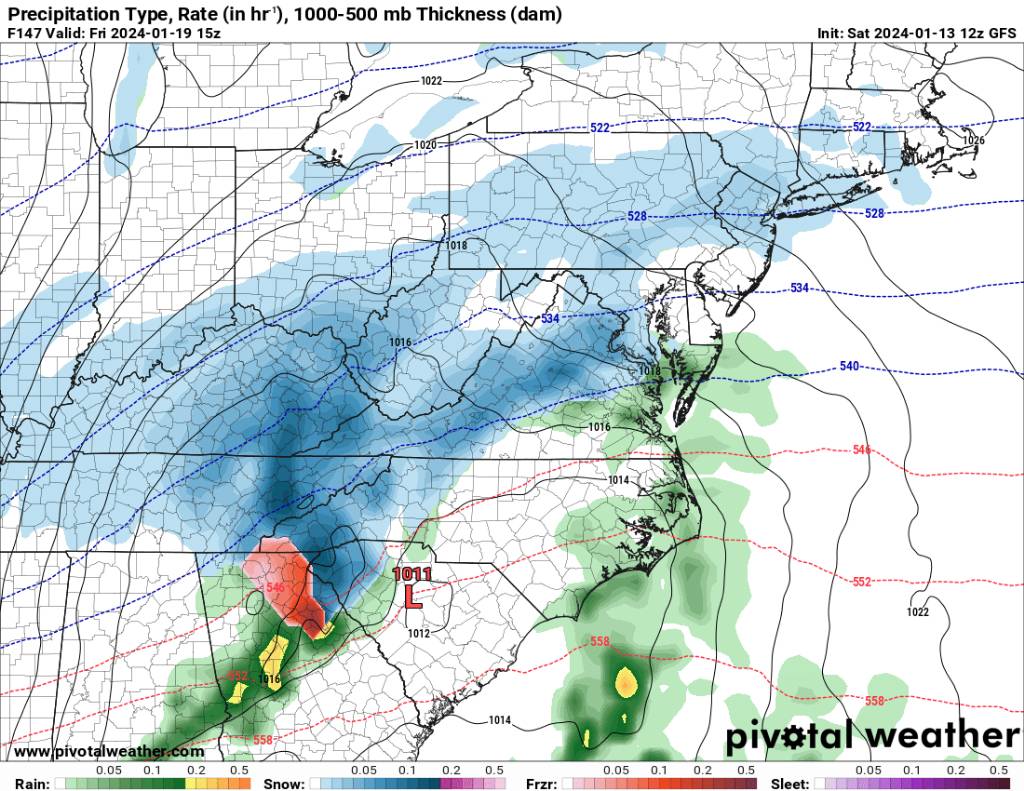
The second wave is looking robust and one heck of an upslope signal still. Sent from my SM-G998U using Tapatalk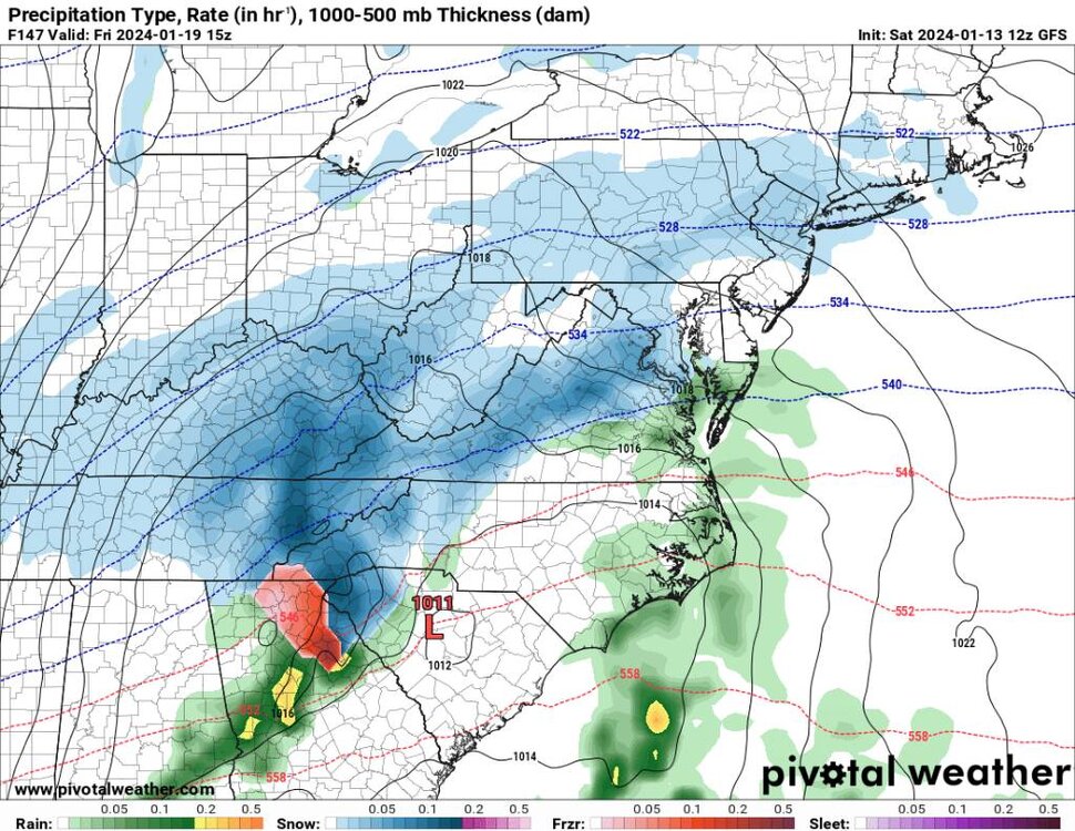
.thumb.jpg.fe702fe565b0a04089b1336cccb443d3.jpg)
.thumb.jpg.1de3f00db9bff5d48a053ffdcb656d71.jpg)
.thumb.jpg.bc9bfa9b408fd66723b0e9dbc58a25e0.jpg)
.thumb.jpg.bd2701dfd34522bd32fcb6cda2687854.jpg)
-
2023-2024 Fall/Winter Mountain Thread
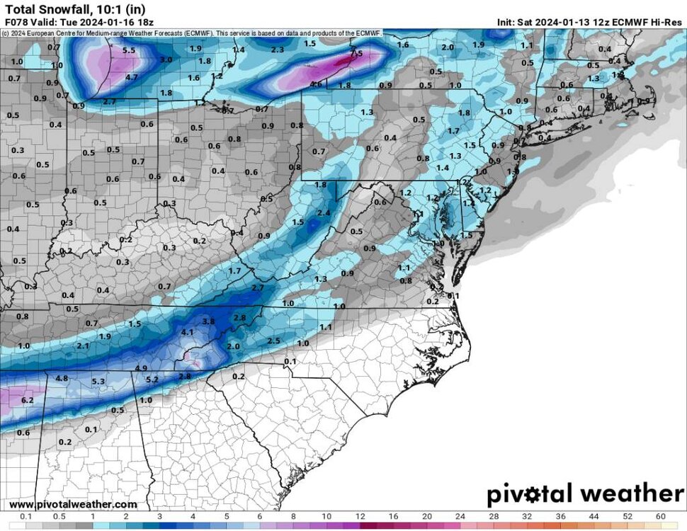
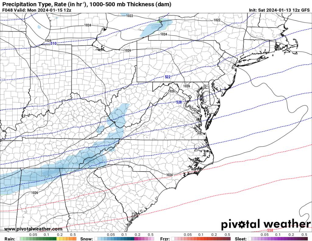
Met1985 replied to The Alchemist's topic in Southeastern States
12z gfs on the first wave still look very good. Sent from my SM-G998U using Tapatalk
.thumb.jpg.116f64f25fe07967bdd08a6f60776f3d.jpg)
.thumb.jpg.08082a7e03046f033c204c32c4c7fcc4.jpg)
.thumb.jpg.957c9c3ec50d4bf6a17fefe6f9bf3ab4.jpg)
-
Post some pics. That is crazy. I was reading we're some ski resort out in Utah was going to get over 70 inches this weekend alone.
-
Jan Medium/Long Range Disco 2: Total Obliteration is Coming
Met1985 replied to Jebman's topic in Mid Atlantic
Very well said and you are exactly right. The EPS and the weeklies have done a great job with the pattern recognition basically in the 7 to 30 day period. Been riding both of those all season and I see no reason to stop now. -
2023-2024 Fall/Winter Mountain Thread
Met1985 replied to The Alchemist's topic in Southeastern States
Remember that the models just recently have turned more south with the axis of the main precipitation. It wasn't until the 00z gfs that things started to turn more favorable. GSP are just playing it safe because we've literally been we're TN is to only get completely screwed... -
2023-2024 Fall/Winter Mountain Thread
Met1985 replied to The Alchemist's topic in Southeastern States
This feature reminds me of the torrential rainfall we saw at the first of the week having literally streams of moisture come right from over the gulf stream. I would think this would bode very well in tossing more moisture into the system and for a longer duration. But great catch and you the man. -
2023-2024 Fall/Winter Mountain Thread
Met1985 replied to The Alchemist's topic in Southeastern States
Yeah our weather patterns have changed over the past several years. -
2023-2024 Fall/Winter Mountain Thread
Met1985 replied to The Alchemist's topic in Southeastern States
You know we always get some great flow snows when we have a strong cold low on the coast. Several times we've had this happen and deliver. -
2023-2024 Fall/Winter Mountain Thread
Met1985 replied to The Alchemist's topic in Southeastern States
Dang, beautiful Hunter! -
2023-2024 Fall/Winter Mountain Thread
Met1985 replied to The Alchemist's topic in Southeastern States
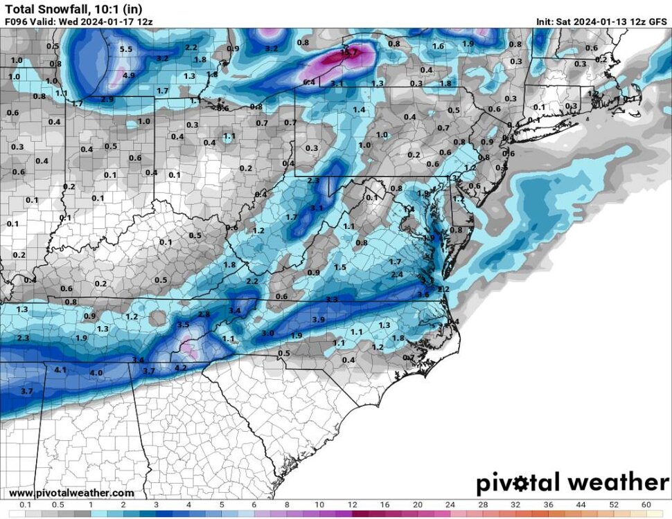
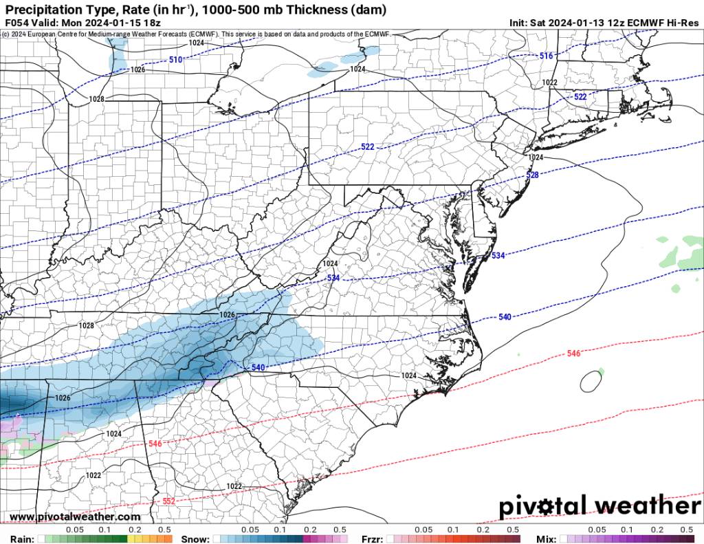
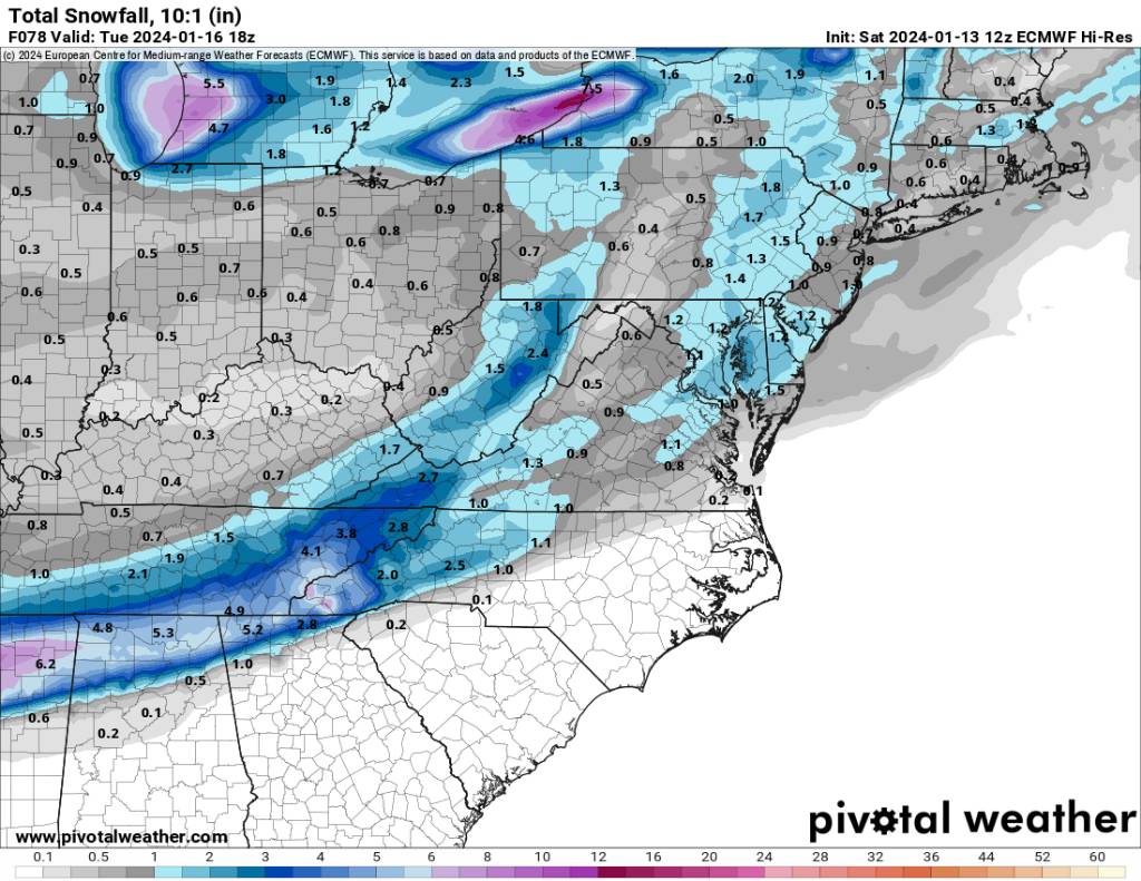
With the onset of the first flakes literally just 2 to 2.5 days away we are watching exactly what I thought would happen and what a good position we are in really statewide at the moment. This is turning into possibly the best scenario for us.

.jpg.67805ffb580117976c1074df9d3b84ce.jpg)
.jpg.6b491e1a877ea0055631f2eaaac81941.jpg)

.jpg.4acf076af1acb3d96c08950549bb84c6.jpg)
.jpg.3e1f5fec1516640a2575722eb3114cb2.jpg)
.jpg.a7c28798b90fdd3b2755562d5bb47b01.jpg)
.jpg.03bc8553f05b3c1d8826dbc492a059dc.jpg)
.jpg.3980ecc42dcf770a153b3ebcbde76ae0.jpg)
.jpg.7e33d3ce2769e6242ea274e96900bc43.jpg)
.jpg.a372925a6efce862984bbdf0cf85623d.jpg)
