

Met1985
-
Posts
15,283 -
Joined
-
Last visited
Content Type
Profiles
Blogs
Forums
American Weather
Media Demo
Store
Gallery
Everything posted by Met1985
-
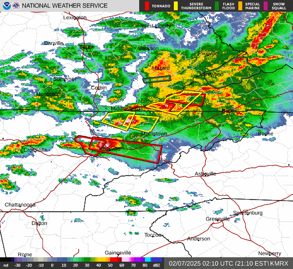
Looks like an absolute mess around the mountains this week.
-
Ashe-Alleghany NC-Bland-Giles-Wythe-Pulaski-Montgomery-Grayson- Carroll-Floyd-Craig-Alleghany VA-Bath-Roanoke-Patrick-Franklin- Mercer-Summers-Monroe-Eastern Greenbrier-Western Greenbrier- Including the cities of Rocky Mount, Blacksburg, Independence, Galax, Whitetop, Salem, Quinwood, Troutdale, Duo, Pulaski, Lewisburg, Wytheville, West Jefferson, Alderson, Covington, Union, Floyd, Radford, New Castle, Sparta, Bluefield, Flat Top, Pearisburg, White Sulphur Springs, Roanoke, Rainelle, Stuart, Bland, Clifton Forge, Hinton, Hix, Volney, and Hot Springs 234 PM EST Sun Feb 9 2025 ...WINTER STORM WATCH IN EFFECT FROM LATE MONDAY NIGHT THROUGH WEDNESDAY AFTERNOON... * WHAT...Heavy mixed precipitation possible. Total snow accumulations of 1 to 6 inches and ice accumulations around three tenths of an inch possible. Some light sleet accumulations as well. * WHERE...Portions of northwest North Carolina, southwest Virginia, and southeast West Virginia. * WHEN...From late Monday night through Wednesday afternoon. * IMPACTS...Ice accumulation on power lines and tree limbs may cause power outages. Power outages and tree damage are possible due to the ice. The hazardous conditions could impact the Tuesday morning and evening commutes.
-
06z gfs and 00z euro Sent from my SM-G998U using Tapatalk
.thumb.jpg.ae2923e705f548f29b028b09f70e99a7.jpg)

-
Yeah we got hammered last night and early this morning. Looks like a lot more rainfall coming our way.
-
Severe thunderstorm warning for northern Haywood into Madison and right over Asheville.
-
Impressive Sent from my SM-G998U using Tapatalk
-
Heads up for the guys along the border. Some big strong severe cells moving through East TN tonight into our area.
-
Freaking beautiful up there. Looks completely different in the snow.
-
Gfs and EURO both picking up on a shuffle around the 8th across the continent. Are we going to be wall to wall cold no but I do think we break this warm pattern down a bit. Sent from my SM-G998U using Tapatalk
.thumb.jpg.4b0c9c87da97d26d0b8d7c41bb2d7cbd.jpg)
-
The mjo isn't the only driver in the atmosphere. Some on here act like it's god tier in running the pattern which is complete bullshit but whatever. Most of February looks warm but the second half is a wild card for me but yall keep talking about grass seed and such. Heck yall down east are done with winter anyways...
-
Yeah temp has dropped here to 36. Looks like we will get a reprieve from the pattern the next few weeks. I think we see a pattern back similar to this month come in around the end of February.
-
We had some flakes overnight but the moisture just couldn't get in here
-
It's a bit warm here at 41 degrees.
-
Already getting reports of flakes flying in Northern Jackson County.
-
18z gfs looks good also. Sent from my SM-G998U using Tapatalk
.thumb.jpg.62541be4611c620eca4a9363276b5bf1.jpg)
-
Yeah it really will be. Temp for highs in the teens and lows around 0 make for some intense days.
-
Yeah we really need a few inches of rainfall here.
-
I'd say we see a half inch to maybe 2 inches. We just need to get the moisture in here. Sent from my SM-G998U using Tapatalk

.thumb.jpg.c67fdd3b84c8f8dbbb6e623f43a689be.jpg)
-
It's been so cold we haven't had any big moisture makers.
-
00z euro. Doesn't look like torch or freezing cold. Honestly looks close to normal. Sent from my SM-G998U using Tapatalk

.thumb.jpg.7a71e46014a4052914704e53f2a3f4ce.jpg)
.thumb.jpg.8dcaae03e8a984079ce3d9b36bda0464.jpg)
-
Yeah from looking at better chances it looks like maybe the second week in February before we another shuffle but the Euro showed a pretty normal pattern setting up. Some highs and lows. We've basically been well below normal the entire month of January.
-
Flurries just started here. I can look out towards up the river and tell they are getting legit light snow. The cutoff of clouds are at the Haywood Buncombe line that I can see.
-
I don't think so. Euro did not scream torch. The AO is currently positive and the gulf coast just got a foot of snow...
-
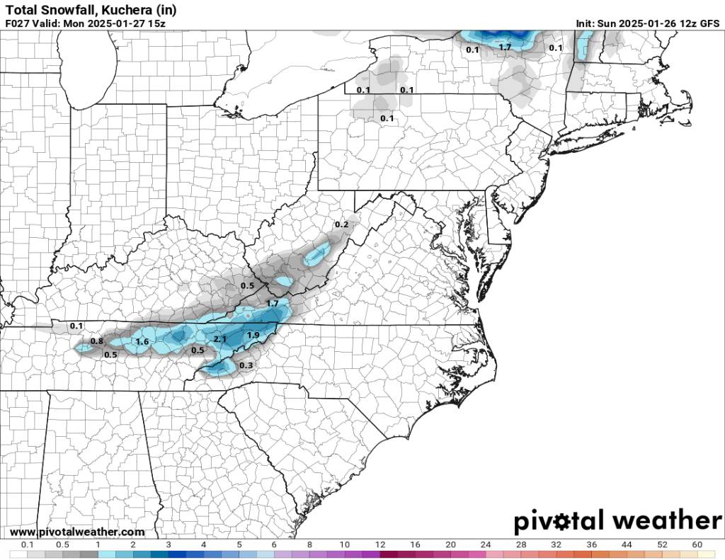
06z gfs Sent from my SM-G998U using Tapatalk
.thumb.jpg.cf0fbfc33e1a3aae6399efccfcf7ae9a.jpg)
-
Had a low of 13..cloudy now but cannot confirm flurries..just cold as this whole month has been that way. Looks like about chance of possible snow Sunday night into Monday morning


.jpg.7bac4128e5b00b3c801e8da0f60ab971.jpg)
.jpg.9b4fc2c9ad5c0483aec98a6144ce62c5.jpg)


.jpg.65280465a81c52e28222b3577ce4f617.jpg)
.jpg.4a7a7c5f750d7b6039b9967dc4b03fb4.jpg)


.jpg.87b9378798285d749a73b6531fe6b57c.jpg)
.jpg.ac79036a7594a6b90e99e071fdafa3b1.jpg)

.jpg.f4ae1ce373334064cb969f30343b845a.jpg)