Met1985
-
Posts
15,299 -
Joined
-
Last visited
Content Type
Profiles
Blogs
Forums
American Weather
Media Demo
Store
Gallery
Everything posted by Met1985
-

2023-2024 Fall/Winter Mountain Thread
Met1985 replied to The Alchemist's topic in Southeastern States
NAM and the gfs look great for the upcoming event. Sent from my SM-G998U using Tapatalk.thumb.jpg.8227b2e76a24e5c849c21797dcc8b5ac.jpg)
-
2023-2024 Fall/Winter Mountain Thread
Met1985 replied to The Alchemist's topic in Southeastern States
Yes sir this looks like a solid event. -
2023-2024 Fall/Winter Mountain Thread
Met1985 replied to The Alchemist's topic in Southeastern States
It likes to do that. Definitely take it with a grain of salt. Probably cut those numbers by 1/3 but still a solid 8-12" event. Tyler let us just fantasize a little bit lol. -
2023-2024 Fall/Winter Mountain Thread
Met1985 replied to The Alchemist's topic in Southeastern States
Yes sir! -
2023-2024 Fall/Winter Mountain Thread
Met1985 replied to The Alchemist's topic in Southeastern States
Yep. Crazy. -
No kidding! The whiplash in this thread is for weenies....
-
2023-2024 Fall/Winter Mountain Thread
Met1985 replied to The Alchemist's topic in Southeastern States
12k NAM is very strong also. Get ready. Sent from my SM-G998U using Tapatalk.thumb.jpg.d3f5d4b67b8842326ff9e5ba7b5410c5.jpg)
-
2023-2024 Fall/Winter Mountain Thread
Met1985 replied to The Alchemist's topic in Southeastern States
3k NAM says this is going to be a nice event. Sent from my SM-G998U using Tapatalk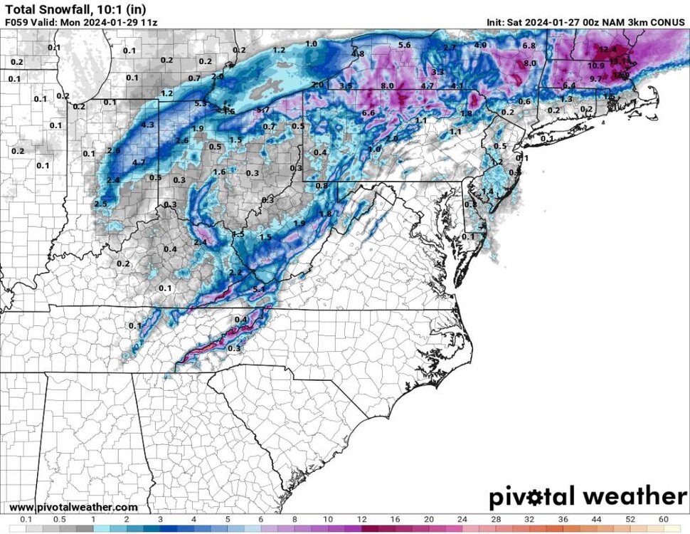
-
Something will hit statewide.
-
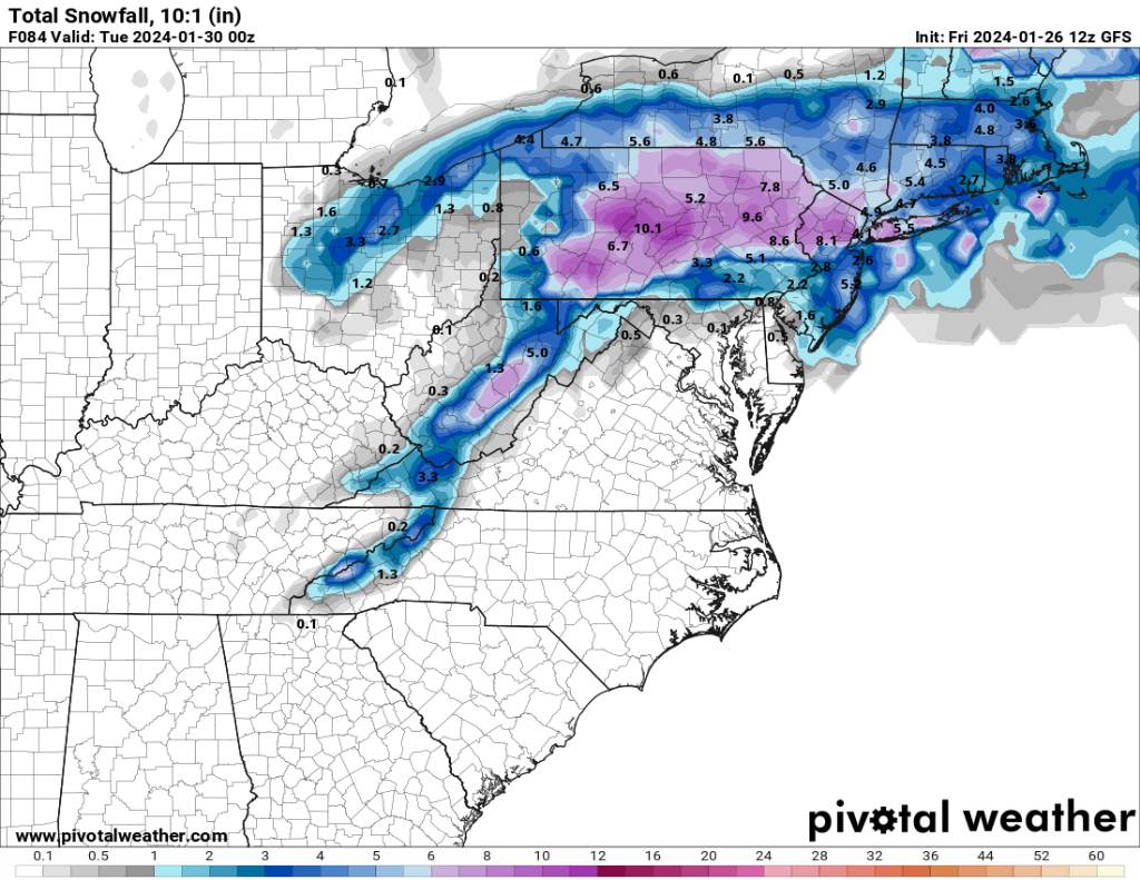
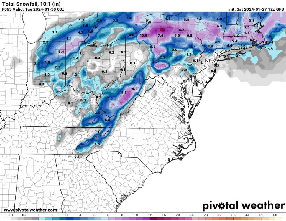
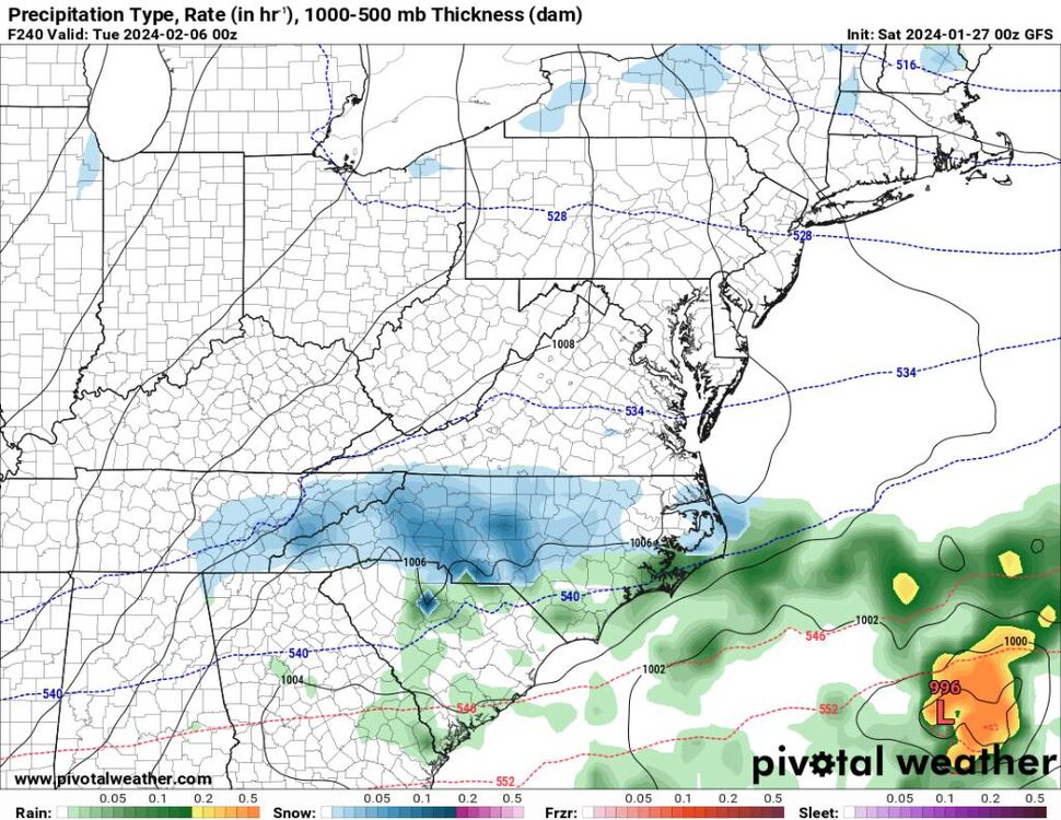
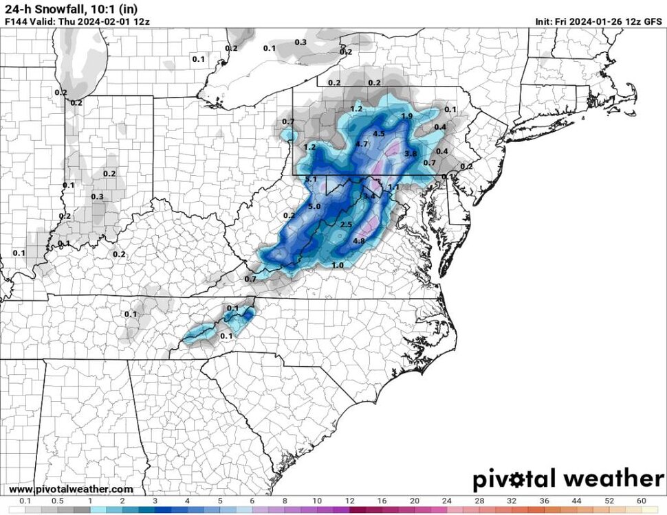
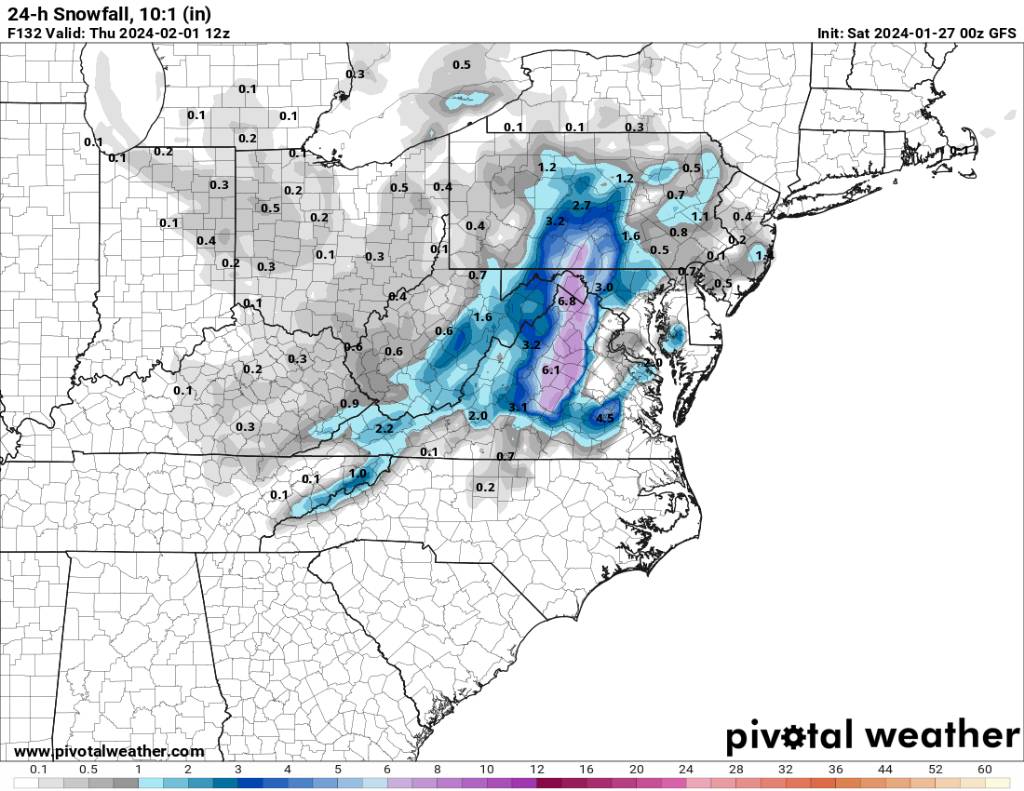
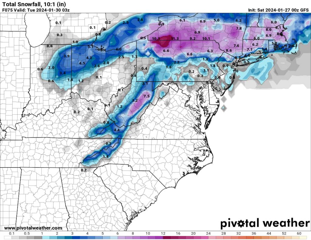
2023-2024 Fall/Winter Mountain Thread
Met1985 replied to The Alchemist's topic in Southeastern States
A nice event statewide. 24 hour snowfall and total snowfall through 10 days. Sent from my SM-G998U using Tapatalk
.thumb.jpg.8f6a65d7e76734f6ae9ad26fc7dde2cf.jpg)
.thumb.jpg.71052bfc68ec48d62068c4489c401fc0.jpg)
.thumb.jpg.4a68bd156b90ee58433a1d7ccdce162e.jpg)
.thumb.jpg.01040d9672691c44cc127f922c68e17e.jpg)
-
2023-2024 Fall/Winter Mountain Thread
Met1985 replied to The Alchemist's topic in Southeastern States
Two upslope events in one week during a torch? Ok... Sent from my SM-G998U using Tapatalk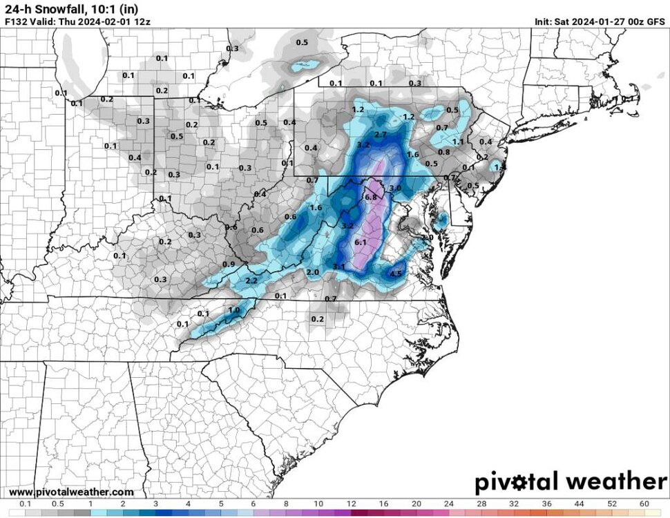
-
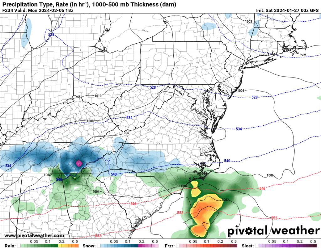
2023-2024 Fall/Winter Mountain Thread
Met1985 replied to The Alchemist's topic in Southeastern States
Very solid upslope signal. Sent from my SM-G998U using Tapatalk.thumb.jpg.a32da08fd4993dfe7a99a9c59929ebd3.jpg)

-
2023-2024 Fall/Winter Mountain Thread
Met1985 replied to The Alchemist's topic in Southeastern States
Multiple winter threats on the 00z. -
This looks good. Sent from my SM-G998U using Tapatalk
-
2023-2024 Fall/Winter Mountain Thread
Met1985 replied to The Alchemist's topic in Southeastern States
A great look on the weeklies snow mean. Sent from my SM-G998U using Tapatalk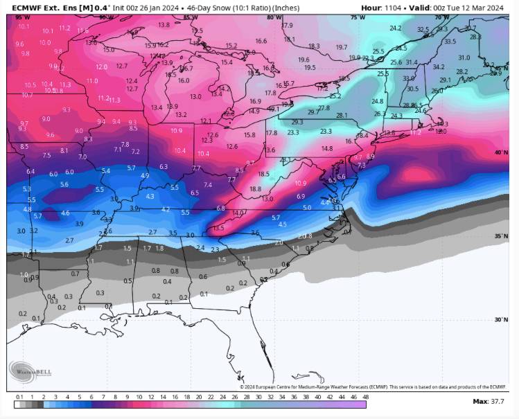
-
Thank you.
- 750 replies
-
- 1
-

-
- snow elk
- wooly worm
- (and 1 more)
-
2023-2024 Fall/Winter Mountain Thread
Met1985 replied to The Alchemist's topic in Southeastern States
Rabun-Habersham-Swain-Graham-Northern Jackson-Macon-Southern Jackson-Transylvania-Henderson-Oconee Mountains-Pickens Mountains- Greenville Mountains- Including the cities of Stecoah, Cedar Mountain, Clayton, Alarka, Cullowhee, East Flat Rock, Pine Mountain, Cashiers, Wolf Mountain, Baldwin, Tuxedo, Almond, Little River, Bryson City, Hollywood, Fletcher, Rocky Bottom, Rainbow Springs, Demorest, Luada, Kyle, Brevard, Robbinsville, Mountain Rest, Dana, Sylva, Franklin, Etowah, Mountain City, Tuckasegee, Glassy Mountain, Wesser, Clarkesville, Highlands, Cornelia, and Hendersonville 238 PM EST Fri Jan 26 2024 ...FLOOD WATCH IN EFFECT FROM SATURDAY MORNING THROUGH LATE SATURDAY NIGHT... * WHAT...Flash flooding caused by excessive rainfall is possible. * WHERE...Portions of northeast Georgia, including the following areas, Habersham and Rabun, western North Carolina, including the following areas, Graham, Henderson, Macon, Jackson, Swain and Transylvania, and upstate South Carolina, including the following areas, Greenville Mountains, Oconee Mountains and Pickens Mountains. * WHEN...From Saturday morning through late Saturday night. -
You mind if I share this in my forum?
- 750 replies
-
- 3
-
-
- snow elk
- wooly worm
- (and 1 more)
-
Yes sir. Things are progressing nicely in my opinion. Great posts Carver.
- 750 replies
-
- 1
-
-
- snow elk
- wooly worm
- (and 1 more)
-
With the info you have posted for El Niño February's this doesn't surprise me in the least. This matches up very well with some of the great February Niños.
-
The storms undercutting the ridge up north is going to bring us something. I mean the jet is going to be bringing in a ton of moisture. Heck we just need a thread the needle type storm.
-
2023-2024 Fall/Winter Mountain Thread
Met1985 replied to The Alchemist's topic in Southeastern States
Yeah after this weekend off to the races along the border. -
2023-2024 Fall/Winter Mountain Thread
Met1985 replied to The Alchemist's topic in Southeastern States
Heck yeah I hit the gym today in shorts and a short sleeve shirt. Feels freaking great! -
2023-2024 Fall/Winter Mountain Thread
Met1985 replied to The Alchemist's topic in Southeastern States
This could possibly turn into something bigger. Sent from my SM-G998U using Tapatalk.thumb.jpg.4d1939fb501ab051bf3c904cbfd8a417.jpg)
-
2023-2024 Fall/Winter Mountain Thread
Met1985 replied to The Alchemist's topic in Southeastern States
Still a strong upslope signal also. Sent from my SM-G998U using Tapatalk.thumb.jpg.00037edc8ca15220cd4ea387e3338be0.jpg)

.jpg.277c0ce5ff053ce3d4f20569ac710ddc.jpg)


.jpg.389521ed7a3ddcb43f81397c41c83913.jpg)

.jpg.6cd98c3491e7daf8ea3e2a210919d688.jpg)
.jpg.727109c1e9b064e656528c935ff9be16.jpg)
.jpg.a299d29cf9b4963b7da1e507808c2fe5.jpg)
.jpg.7a9d4ac6503c430d551fcdf862961522.jpg)
.jpg.69c28288240156fc1b1577e357da9054.jpg)


.jpg.5b4131e2619b3d289990953525cd7c1a.jpg)

.jpg.694a6b5688c66e1136bdecaa4345ced3.jpg)