

Met1985
-
Posts
16,963 -
Joined
-
Last visited
Content Type
Profiles
Blogs
Forums
American Weather
Media Demo
Store
Gallery
Everything posted by Met1985
-

2025 Spring/Summer Mountain Thread
Met1985 replied to Maggie Valley Steve's topic in Southeastern States
Yeah I think that last week was just very anomalous. -
2025 Spring/Summer Mountain Thread
Met1985 replied to Maggie Valley Steve's topic in Southeastern States
Euro looks like several cold shots right to the end of the month. So long 80 degree weather! I still like high elevation chances tonight and into this weekend. I think the models are undergoing the cold air this weekend. I think some may see 1 to 3 inches on grassy surfaces. -
2025 Spring/Summer Mountain Thread
Met1985 replied to Maggie Valley Steve's topic in Southeastern States
I still think some see flakes tomorrow morning and this weekend. This week is going to be a 180 from last week. -
2025 Spring/Summer Mountain Thread
Met1985 replied to Maggie Valley Steve's topic in Southeastern States
Multiple crashes on I40 and I26 this morning. -
2025 Spring/Summer Mountain Thread
Met1985 replied to Maggie Valley Steve's topic in Southeastern States
Very heavy rainfall and storms currently. -
2025 Spring/Summer Mountain Thread
Met1985 replied to Maggie Valley Steve's topic in Southeastern States
We are getting lit up now.... -
2025 Spring/Summer Mountain Thread
Met1985 replied to Maggie Valley Steve's topic in Southeastern States
Some big boomers rolling through this morning. This has been the rain we've needed for the wildfires. -
2025 Spring/Summer Mountain Thread
Met1985 replied to Maggie Valley Steve's topic in Southeastern States
Temps coming in colder each day. Today we were supposed to hit 72 degrees and we managed 58 with current temp of 56. Factually we managed a cheap high around midnight of 66. Tomorrow now we are only supposed to have a high of 56 when this morning we were supposed to hit 62 tomorrow. 48 for a high on Tuesday and a low Tuesday night of 22. That's dang cold for the middle of April. -
2025 Spring/Summer Mountain Thread
Met1985 replied to Maggie Valley Steve's topic in Southeastern States
58 degrees at 1pm. This is more like it. -
2025 Spring/Summer Mountain Thread
Met1985 replied to Maggie Valley Steve's topic in Southeastern States
Wouldn't be surprised to see some flakes flying Tuesday morning at the high peaks. -
2025 Spring/Summer Mountain Thread
Met1985 replied to Maggie Valley Steve's topic in Southeastern States
Yeah and that line wasn't forecast either. I didn't think we would get anything significant until about 2 or 3 today. Temps are much more manageable with it being 56 currently. -
2025 Spring/Summer Mountain Thread
Met1985 replied to Maggie Valley Steve's topic in Southeastern States
This initial line of storms coming through like a bat out of hell. Very gusty winds over 35mph and torrential rainfall. -
2025 Spring/Summer Mountain Thread
Met1985 replied to Maggie Valley Steve's topic in Southeastern States
Also this is a crazy swing from today to Tuesday and Tuesday night. From a high today around 80 degrees to highs in the upper 40s Tuesday to lows in the mid 60s to lows Tuesday night in the low 20s! Talk about whiplash! Some 35 to 40 degree temp change in just a matter of days. -
2025 Spring/Summer Mountain Thread
Met1985 replied to Maggie Valley Steve's topic in Southeastern States
12z gfa absolutely laying the rain and storms down for tomorrow. Upping the totals for several areas. Sent from my SM-G998U using Tapatalk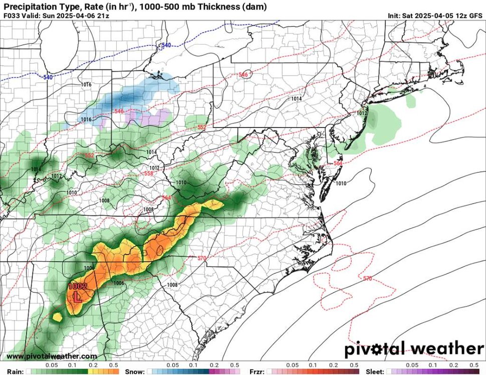
.thumb.jpg.35327dc639e7a6fd13227b6ac6f3771f.jpg)
-
2025 Spring/Summer Mountain Thread
Met1985 replied to Maggie Valley Steve's topic in Southeastern States
Euro back to showing stout cold again. Sent from my SM-G998U using Tapatalk
.thumb.jpg.2d8a865d15c98fb6e159fd2e42c8344d.jpg)
.thumb.jpg.bb0439c698e82241b43b9b168de9e87c.jpg)
.thumb.jpg.5e47420ca7d3be747fbf145dded6aaaf.jpg)
-
2025 Spring/Summer Mountain Thread
Met1985 replied to Maggie Valley Steve's topic in Southeastern States
This weather is straight from hell. 82 degrees for a high today and still 72 currently. I really don't like this type heat this early on. -
2025 Spring/Summer Mountain Thread
Met1985 replied to Maggie Valley Steve's topic in Southeastern States
Hard to say with it 75 plus degrees. We are still about 7 days out. -
2025 Spring/Summer Mountain Thread
Met1985 replied to Maggie Valley Steve's topic in Southeastern States
Thankfully spring is right around the corner again. Sent from my SM-G998U using Tapatalk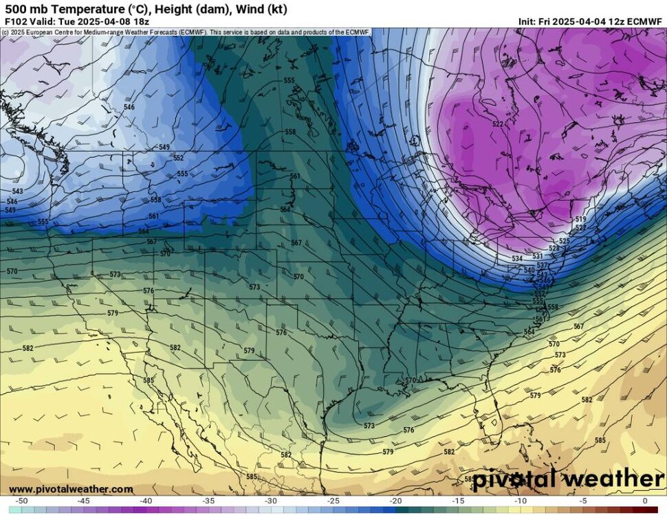
.thumb.jpg.3979fe2043b2c766336b7008e5b67214.jpg)
.thumb.jpg.7ecce2387859cb2ee4a9fa88ed57ed1d.jpg)
-
2025 Spring/Summer Mountain Thread
Met1985 replied to Maggie Valley Steve's topic in Southeastern States
Looks like Sunday when the front blows through here. We will see severe weather and some torrential rainfall from this line. Sent from my SM-G998U using Tapatalk.thumb.jpg.e70e30eab349ee1b9ce7954e40c06f08.jpg)
-
Yeah and just think in about 4 to 5 days having lows back around 20 degrees and we will see flow snow in WNC. CRAZY! Seems like we've had extremes in weather since last July.
-
2025 Spring/Summer Mountain Thread
Met1985 replied to Maggie Valley Steve's topic in Southeastern States
Gfs finally caught onto the second low and cold front dropping down around the 11th that gives us a prolonged flow snow event that would be significant for this time of the year. -
Honestly I'm more or so watching the second more substantial cold front that really dives down on the 11th that's been shown on the Euro for several days. That could give us in the mountains some substantial flow snow so late in the season.
-
That's what makes this even more impressive.
-
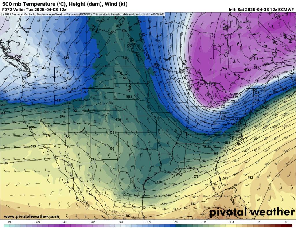
Euro definitely leading this cold blast. Has shown this pattern for several days coming up.
-
I wouldn't be surprised to see this multiple cold front pattern be colder than advertised.


.jpg.bbb4ca11ec637df7305fec6264f16da5.jpg)
.jpg.b5263b0e33a25adc3c94348abebe3281.jpg)
.jpg.338c966de16093489792d1d54048233b.jpg)
.jpg.6cea6a2c05a6cdf4078db19172e5c56a.jpg)

.jpg.3bbd110ac1ff4b0f9a082d2dc133d90c.jpg)
.jpg.f4750195ee6b45759ea49cd3f86587ff.jpg)

.jpg.d08dd3a9984c8592d58493f0d5177ea5.jpg)