

Met1985
-
Posts
15,283 -
Joined
-
Last visited
Content Type
Profiles
Blogs
Forums
American Weather
Media Demo
Store
Gallery
Everything posted by Met1985
-
This is going to be one heck of a squall line. Going to be lots of severe storms. Sent from my SM-G998U using Tapatalk
-
A ton more moisture come up. Sent from my SM-G998U using Tapatalk
-
Fixing to be hammer time. Sent from my SM-G998U using Tapatalk
-
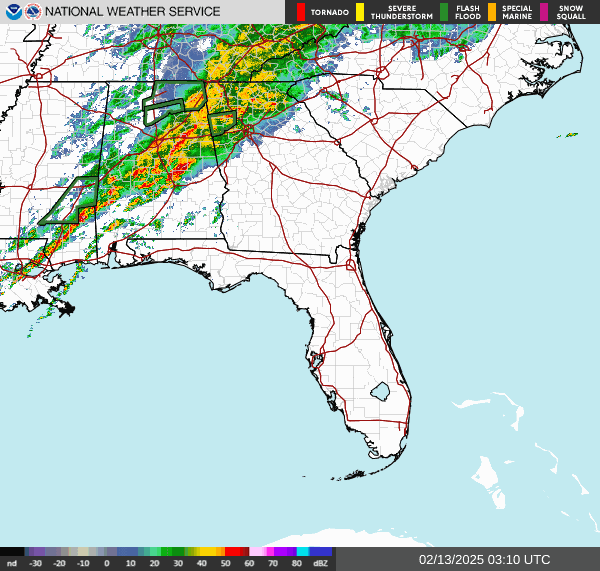
Yeah it's been nonstop heavy since I got home. Going to be a long night I'm afraid.
-
Yeah that's really impressive.
-
Yeah no kidding. Going to rain a lot tonight and looking at severe weather this weekend followed by snow.
-
Creeks and rivers will rise tonight. A lot of heavy rainfall coming overnight from the Gulf of America.
-
Yeah lol. Crazy. Pattern will be ripe for about a month I believe.
-
Yeah no kidding! This could have been really really bad.
-
We are hovering right around 32/33. A shock to the system. Nearly a 40 degree drop in a few days.
-
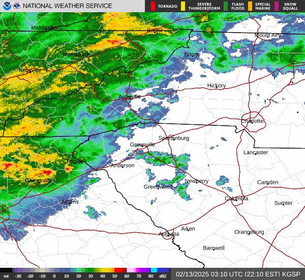
Yeah thought I heard some sleet mixing in with the rain in Asheville today.
-
Sitting right at 32 this morning.
-
Down to 33 currently. Going to be interstate.
-
Yeah no good at all.
-
Temp down to 34 degrees now.
-
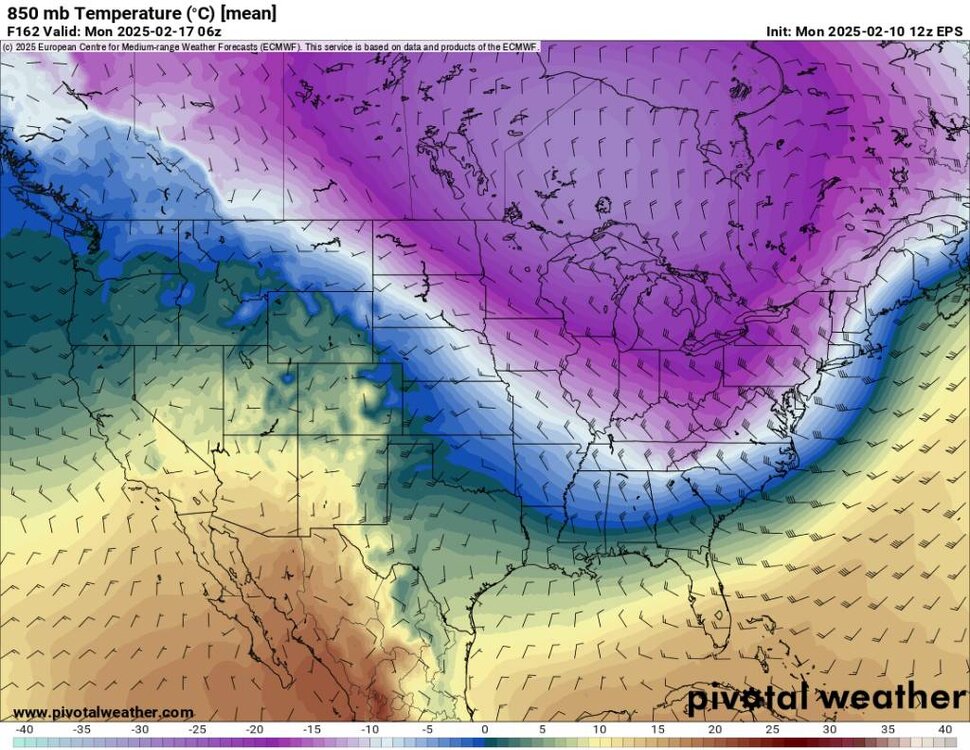
Yeah this cold air has really settled in much further south and seems more dense
-
Temp down to 39 degrees already.
-
Um what's the NAM smoking? Sent from my SM-G998U using Tapatalk
-
This system tonight is trending much much cooler.
-
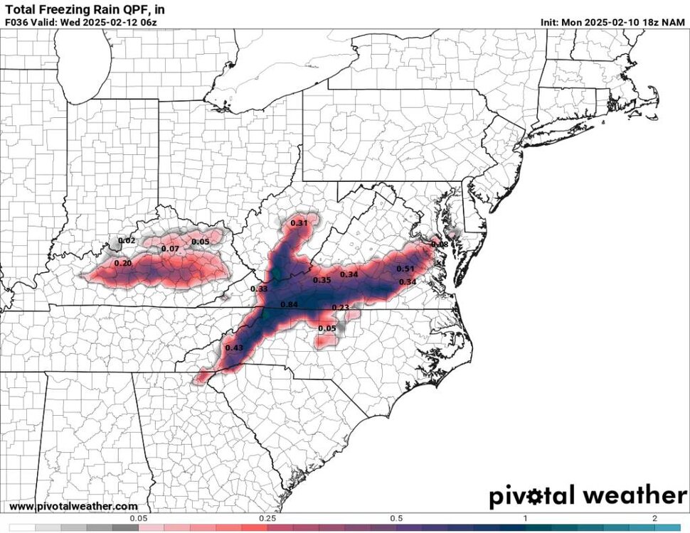
Avery-Alexander-Iredell-Davie-Yancey-Mitchell-Buncombe-Catawba- Henderson-Caldwell Mountains-Greater Caldwell-Burke Mountains- Greater Burke-McDowell Mountains-Eastern McDowell-Rutherford Mountains-Polk Mountains- Including the cities of Etowah, Spruce Pine, Valdese, Fletcher, Ingalls, Dysartsville, Poplar, Mooresville, Lenoir, Marion, Newton, Ramseytown, Morganton, Farmington, Hickory, Asheville, Mocksville, Taylorsville, Sugar Hill, Woodlawn, Statesville, Hendersonville, Burnsville, Chimney Rock State Park, Bethlehem, Newland, Swiss, Glenwood, Kings Creek, Fork Church, Granite Falls, Ellendale, Fero, Stony Point, East Flat Rock, Candler, Tuxedo, Banner Elk, Advance, Dana, Micaville, Jonas Ridge, Millersville, Nebo, Old Fort, Black Mountain, Sawmills, Patterson, Celo, Hiddenite, St. Stephens, Pleasant Grove, Ashford, Saluda, and Busick 214 PM EST Mon Feb 10 2025 ...WINTER WEATHER ADVISORY IN EFFECT FROM 1 AM TUESDAY TO 7 AM EST WEDNESDAY... * WHAT...Freezing rain expected. Precipitation may start out as sleet or a wintry mix in the Northern Mountains overnight tonight, with minor sleet accumulations. Total ice accumulations around two tenths of an inch possible, mainly along the Blue Ridge Escarpment. Piedmont areas are expected to have up to a few hundredths of an inch of ice. * WHERE...The Northern Mountains, portions of the French Broad Valley and adjacent foothills, and most of the Northwest Piedmont in North Carolina. * WHEN...From 1 AM Tuesday to 7 AM EST Wednesday.
-
Winter will come back with a vengeance... Sent from my SM-G998U using Tapatalk
.thumb.jpg.894ce96cec3f62a5e098601109dd3fff.jpg)
-
Yeah the cold air is trending further south.
-
Temperature has fallen off here. At 6pm we were at 61 and currently in sitting at 41.
-
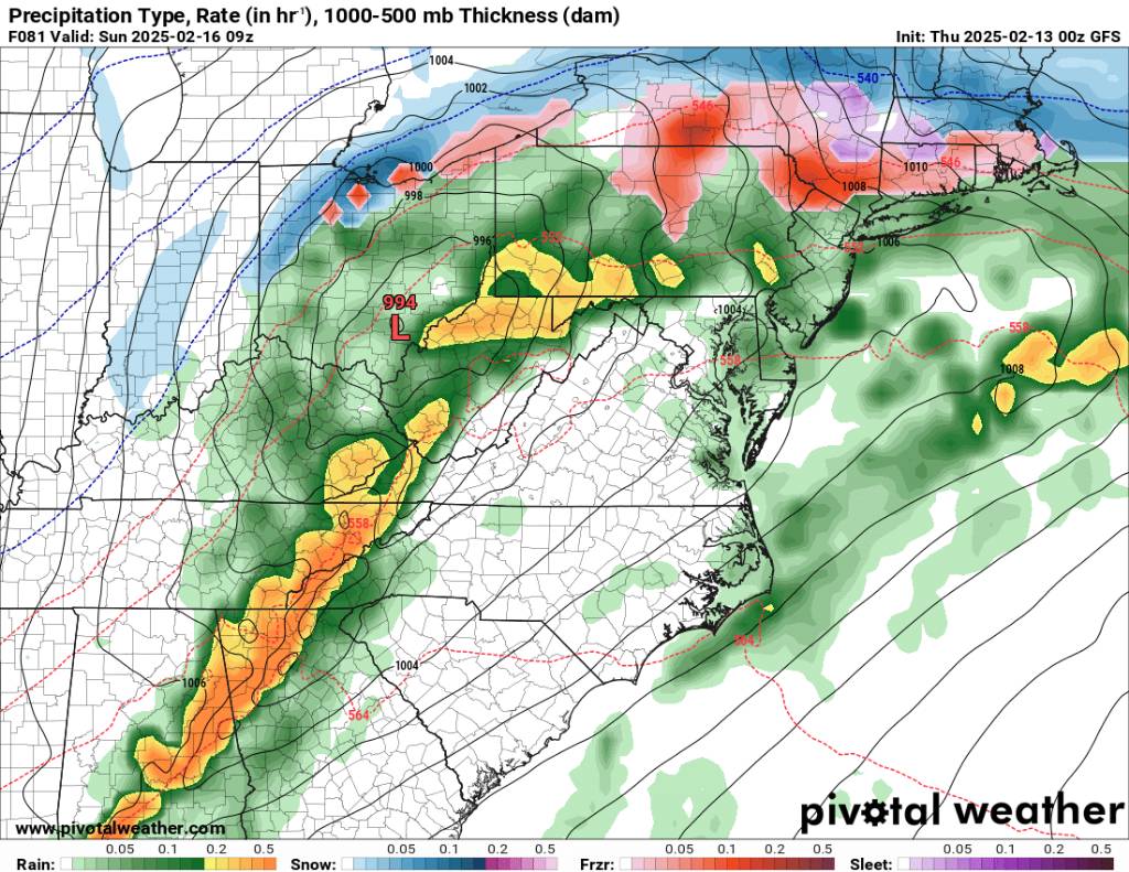
GSP in my opinion doesn't need to sit on this at the last moment. The word needs to get out now. This isn't the time or place to be conservative with the forecast...
-
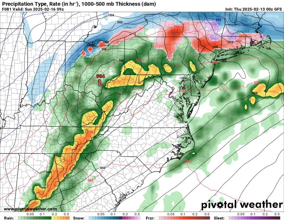
Not a great look by either model. This could bring big time flooding in many places that don't need it. This will be a big test for the area and for the infrastructure. Sent from my SM-G998U using Tapatalk
.thumb.jpg.a559cc0a7cb0a53fff8ebfe4266c4bd6.jpg)


.jpg.694ed0701fc71ac77ac7cbf664d382cf.jpg)

.jpg.cbccb81ef5dbdc01c95c667cc706b954.jpg)