

Met1985
-
Posts
15,299 -
Joined
-
Last visited
Content Type
Profiles
Blogs
Forums
American Weather
Media Demo
Store
Gallery
Everything posted by Met1985
-
I tell you what that 4 to 6 week window you preach about is darn close every single time just about. There is definitely something to that in my opinion going off of your theories.
- 750 replies
-
- 2
-

-
- snow elk
- wooly worm
- (and 1 more)
-

2023-2024 Fall/Winter Mountain Thread
Met1985 replied to The Alchemist's topic in Southeastern States
34 with moderate to heavy rainfall this afternoon. -
2023-2024 Fall/Winter Mountain Thread
Met1985 replied to The Alchemist's topic in Southeastern States
Going to be a very wet afternoon. Sent from my SM-G998U using Tapatalk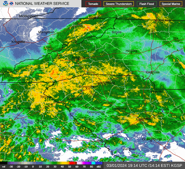
-
2023-2024 Fall/Winter Mountain Thread
Met1985 replied to The Alchemist's topic in Southeastern States
Nice! Thank you. -
2023-2024 Fall/Winter Mountain Thread
Met1985 replied to The Alchemist's topic in Southeastern States
Just getting blasted out west. https://www.mammothmountain.com/on-the-mountain/mammoth-webcam/the-summit -
2023-2024 Fall/Winter Mountain Thread
Met1985 replied to The Alchemist's topic in Southeastern States
Impressed with the cold air entrenched today. Temps been hovering around 32/33 all morning..we still have ice hanging around from earlier. -
2023-2024 Fall/Winter Mountain Thread
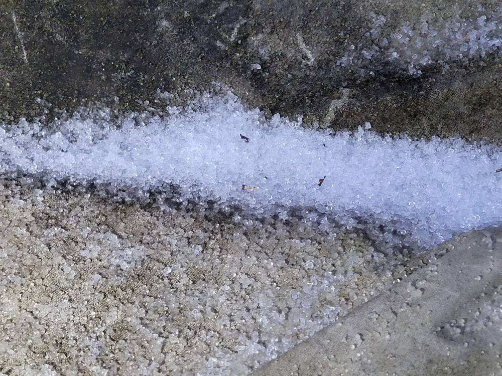
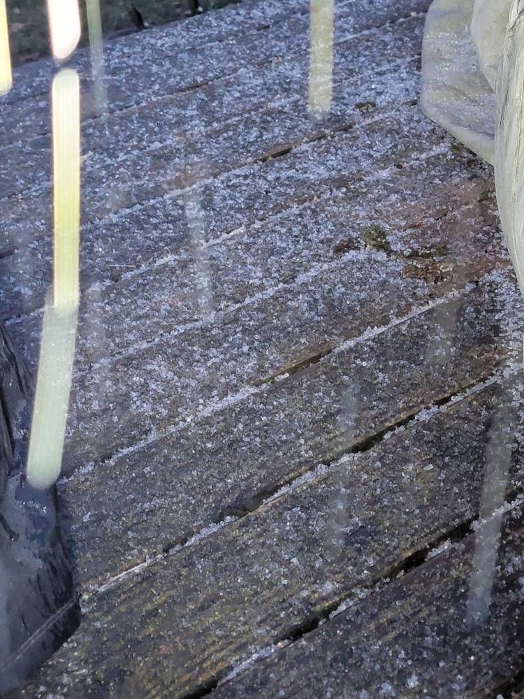
Met1985 replied to The Alchemist's topic in Southeastern States
Some deck ice pics..still icing moderately currently. Sent from my SM-G998U using Tapatalk
-
2023-2024 Fall/Winter Mountain Thread
Met1985 replied to The Alchemist's topic in Southeastern States
Silver dollar flakes mixing in. -
2023-2024 Fall/Winter Mountain Thread
Met1985 replied to The Alchemist's topic in Southeastern States
Heavy icing currently covering the deck and sidewalk. -
2023-2024 Fall/Winter Mountain Thread
Met1985 replied to The Alchemist's topic in Southeastern States
Mixture of sleet and snow currently. -
2023-2024 Fall/Winter Mountain Thread
Met1985 replied to The Alchemist's topic in Southeastern States
Correction it's been sleeting here. We have a skiff in the deck. -
2023-2024 Fall/Winter Mountain Thread
Met1985 replied to The Alchemist's topic in Southeastern States
Nothing yet here but temp is 33 degrees. -
2023-2024 Fall/Winter Mountain Thread
Met1985 replied to The Alchemist's topic in Southeastern States
Swain-Haywood-Graham-Northern Jackson-Macon-Southern Jackson- Transylvania- Including the cities of Rainbow Springs, Kyle, Highlands, and Cashiers 451 AM EST Fri Mar 1 2024 ...WINTER WEATHER ADVISORY REMAINS IN EFFECT UNTIL NOON EST TODAY ABOVE 3500 FEET... * WHAT...Mixed precipitation expected. Ice accumulation of up to five hundredths of an inch, especially on elevated surfaces. * WHERE...Elevations above 3500 feet in Swain, Haywood, Graham, Jackson, Macon, and Transylvania Counties. * WHEN...Until noon EST today. * IMPACTS...Plan on slippery road conditions. The hazardous conditions could impact the morning or evening commute. -
Damn really? I guess our elevation here helps a lot especially when you live at 3500' or higher.
-
2023-2024 Fall/Winter Mountain Thread
Met1985 replied to The Alchemist's topic in Southeastern States
Temp down to 32 now. -
2023-2024 Fall/Winter Mountain Thread
Met1985 replied to The Alchemist's topic in Southeastern States
Temp down to 36 already. -
2023-2024 Fall/Winter Mountain Thread
Met1985 replied to The Alchemist's topic in Southeastern States
The Euro is just showing rain. -
2023-2024 Fall/Winter Mountain Thread
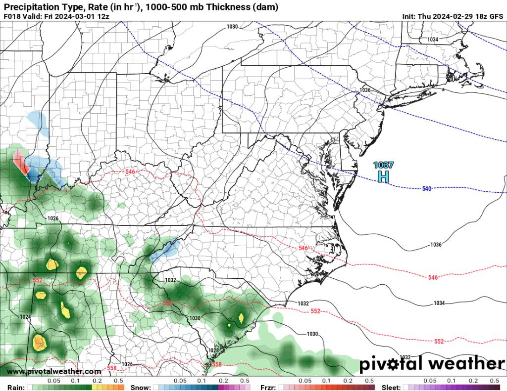
Met1985 replied to The Alchemist's topic in Southeastern States
18z nam Sent from my SM-G998U using Tapatalk
-
2023-2024 Fall/Winter Mountain Thread
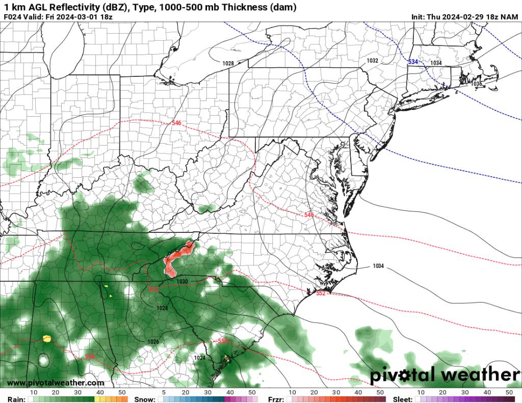
Met1985 replied to The Alchemist's topic in Southeastern States
Latest gfs run Sent from my SM-G998U using Tapatalk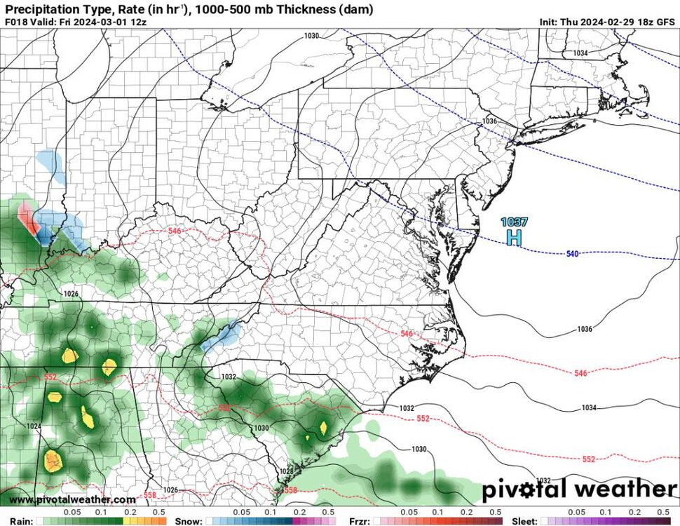
.thumb.jpg.175a4e501fc27a63b959f8baea593aef.jpg)
-
2023-2024 Fall/Winter Mountain Thread
Met1985 replied to The Alchemist's topic in Southeastern States
Haywood-Buncombe-Northern Jackson-Southern Jackson-Transylvania- Henderson-Caldwell Mountains-Burke Mountains-McDowell Mountains- 303 PM EST Thu Feb 29 2024 This Hazardous Weather Outlook is for western North Carolina. .DAY ONE...This afternoon and tonight. Hazardous weather is not expected at this time. .DAYS TWO THROUGH SEVEN...Friday through Wednesday. Precipitation will develop across the area Friday morning. Enough cold air is expected to be in place for pockets of a wintry mix to develop over the mountains, with freezing rain expected to be the predominant type of winter precipitation. A light glaze of ice will be possible, especially across high elevations and in sheltered areas near the Blue Ridge escarpment. Warm road temperatures will limit the potential for significant travel difficulties, but a few slick spots could develop. -
2023-2024 Fall/Winter Mountain Thread
Met1985 replied to The Alchemist's topic in Southeastern States
Watauga- Including the city of Boone 242 PM EST Thu Feb 29 2024 ...WINTER WEATHER ADVISORY IN EFFECT FROM 7 AM TO 7 PM EST FRIDAY... * WHAT...Mixed precipitation expected. Ice accumulations of up to one tenth of an inch. * WHERE...Watauga County. * WHEN...From 7 AM to 7 PM EST Friday. -
2023-2024 Fall/Winter Mountain Thread
Met1985 replied to The Alchemist's topic in Southeastern States
Yancey-Mitchell- 300 PM EST Thu Feb 29 2024 ...WINTER WEATHER ADVISORY IN EFFECT FROM 7 AM TO 7 PM EST FRIDAY ABOVE 3500 FEET... * WHAT...Mixed precipitation expected. Ice accumulation of up to five hundredths of an inch, with a dusting of snow also possible. Winds gusting as high as 35 mph. * WHERE...Elevations above 3500 feet in Yancey and Mitchell Counties. * WHEN...From 7 AM to 7 PM EST Friday. -
2023-2024 Fall/Winter Mountain Thread
Met1985 replied to The Alchemist's topic in Southeastern States
Wind is cranking and temp down to 39 here. -
2023-2024 Fall/Winter Mountain Thread
Met1985 replied to The Alchemist's topic in Southeastern States
Down to 46 here. Wind has definitely picked up. -
2023-2024 Fall/Winter Mountain Thread
Met1985 replied to The Alchemist's topic in Southeastern States
Impressive line coming through. Sent from my SM-G998U using Tapatalk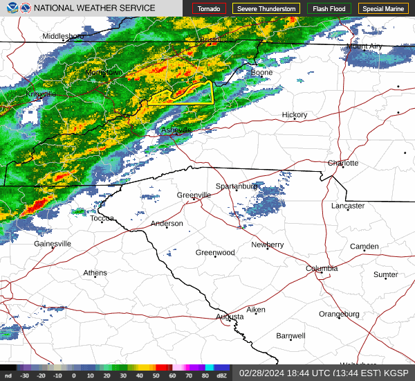

.jpg.93440510c6048d422db9d0900796ebd1.jpg)