

Met1985
-
Posts
15,300 -
Joined
-
Last visited
Content Type
Profiles
Blogs
Forums
American Weather
Media Demo
Store
Gallery
Everything posted by Met1985
-
Yeah cloud deck coming down at Biltmore.
-
Severe Thunderstorm Warning for... Southwestern Madison County in western North Carolina... Northwestern Haywood County in western North Carolina... * Until 130 PM EDT. * At 1235 PM EDT, a severe thunderstorm was located 11 miles southeast of Newport, or 4 miles north of Smoky Mountains-Big Creek, moving east at 35 mph. HAZARD...60 mph wind gusts and half dollar size hail. SOURCE...Radar indicated. IMPACT...Minor hail damage to vehicles is expected. Expect wind damage to trees and power lines.
-
Heads up for Madison County!
-
Severe Thunderstorm Warning for... Madison County in western North Carolina... * Until 130 PM EDT. * At 1217 PM EDT, a severe thunderstorm was located 9 miles east of Newport, or 5 miles southeast of Parrottsville, moving east at 40 mph. HAZARD...60 mph wind gusts and half dollar size hail. SOURCE...Radar indicated. IMPACT...Minor hail damage to vehicles is expected. Expect wind damage to trees and power lines.
-
Impressive bow echo.
-
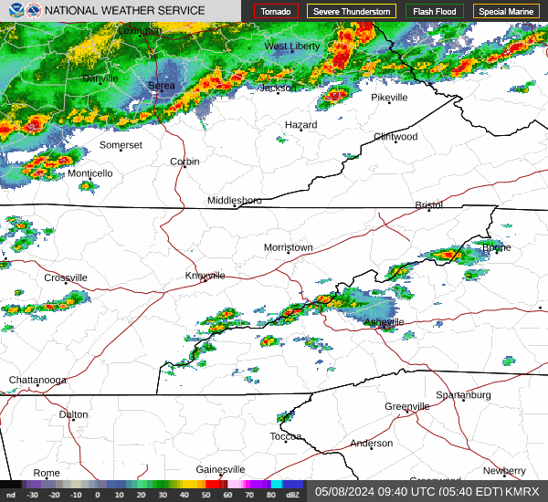
Another look. Sent from my SM-G998U using Tapatalk
-
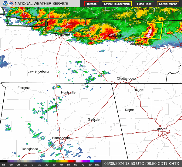
Radar from Tennessee Sent from my SM-G998U using Tapatalk
.gif.ca4296ee9186a9fda44e5e78c657f843.gif)
-
Just beat me too it. Things are gonna be rocking later on.
-
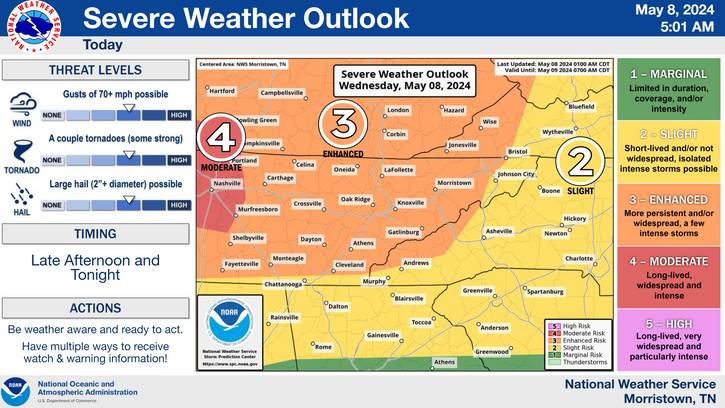
Rabun-Habersham-Stephens-Franklin-Hart-Elbert-Avery-Alexander- Iredell-Davie-Madison-Yancey-Mitchell-Swain-Haywood-Buncombe-Catawba- Rowan-Graham-Northern Jackson-Macon-Southern Jackson-Transylvania- Henderson-Cleveland-Lincoln-Gaston-Mecklenburg-Cabarrus-Union NC- Caldwell Mountains-Greater Caldwell-Burke Mountains-Greater Burke- McDowell Mountains-Eastern McDowell-Rutherford Mountains- Greater Rutherford-Polk Mountains-Eastern Polk-Cherokee-York- Anderson-Abbeville-Laurens-Union SC-Chester-Greenwood- Oconee Mountains-Pickens Mountains-Greenville Mountains- Greater Oconee-Greater Pickens-Central Greenville- Southern Greenville-Northern Spartanburg-Southern Spartanburg- 546 AM EDT Wed May 8 2024 This Hazardous Weather Outlook is for northeast Georgia, piedmont North Carolina, western North Carolina and upstate South Carolina. .DAY ONE...Today and tonight. Isolated to scattered thunderstorms are expected to develop across the area today, especially this afternoon and evening. Isolated severe storms are expected during this time, with the main threats being from large hail and brief damaging wind gusts. A couple of the storms could produce hail larger than golf balls. An isolated tornado or two cannot be ruled out. A complex of strong to severe storms is then expected to move across the area overnight into early Thursday. This system will pose a threat for more widespread strong to damaging wind gusts and perhaps a brief tornado. Areas that receive multiple rounds of storms will see a threat for excessive rainfall and flash flooding, especially tonight.
-
Storms starting to fire already this morning. Looks like we are going to see 2 to 3 shots at severe storms today through tonight. Sent from my SM-G998U using Tapatalk
-
Going to be an active and dangerous 24 hours.... Sent from my SM-G998U using Tapatalk
-
Looks like the next 72 hours are going to be rocking around here. Especially all day tomorrow into tomorrow night things could get pretty ugly across the viewing area Especially coming from Tennessee.
-
I counted 4 storms that rolled through from about noon yesterday to 2 am this morning. Over 2 inches fell in about 14 hours.
-
Yeah it definitely doesn't look as cool but I still think we see a few good cold shots to at least temper the heat.
-
Another foot of snow for the Colorado mountains as well.
-
Palisade Tahoe set a record this weekend.
-
Big time storms coming from Tennessee.
-
Yeah these storms have been impressive.
-
Looks like Wednesday will be prime time for severe weather.
-
Got hammered yesterday and today around noon. Looks like more tonight.
-
Good Lord it looks like it rocking hard down there. The rain forest is definitely making it's way.
-
Yeah looks like an active day.
-
More to come as well.
-
Yes sir! Nice steady rains all day and currently.
-
Euro and GFS continue to show this upcoming pattern change.

