Met1985
-
Posts
15,282 -
Joined
-
Last visited
Content Type
Profiles
Blogs
Forums
American Weather
Media Demo
Store
Gallery
Everything posted by Met1985
-
Honestly not a bad look from the 12z gfs. Sent from my SM-G998U using Tapatalk
.thumb.jpg.afc120ca67dc4dd7b15a4b293c1763c6.jpg)
-
Yeah still a lot to workout. Obviously we aren't going to play the sky is falling here but just commenting on it at this time.
-
Not the trends we want to see this morning on the models for here but still a few days away. Current temp of 50 degrees. Temps should start crashing soon.
-
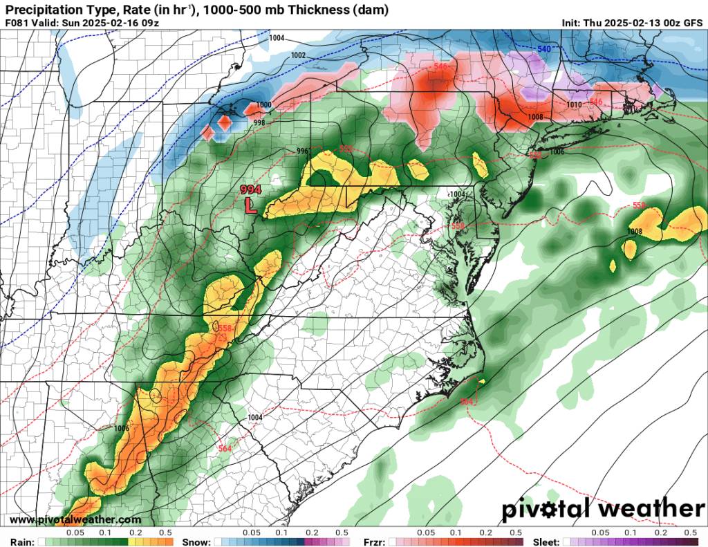
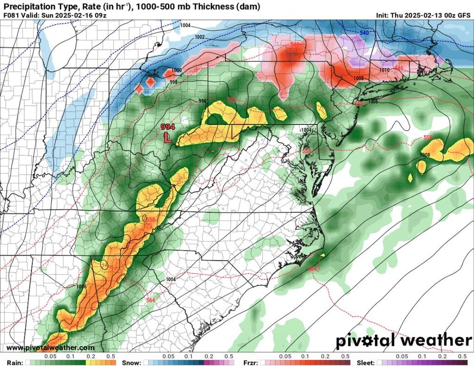
This is the nasty line that's going to be screaming through here are 6 am. Tornado watch already up in TN for this line. Sent from my SM-G998U using Tapatalk
-

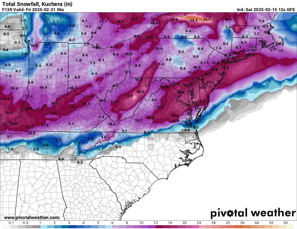
February 19-20 Major Winter Storm Threat
Met1985 replied to NorthHillsWx's topic in Southeastern States
Good Lord IV not seen you post in forever! Glad to see you back. -
I agree with Burns. I'd just make sure he has plenty of amenities, he had emergency numbers that are local and people you trust, and you just sit him down and talk about what to do in case of a severe ice storm. Just prepare for the worst and make sure you set him up or success and not failure just in case.
-
It looks really solid. This is really close to a true Miller A. Coming through and then bombing out on the coast which we always do great on the back side of these storms.
-
The 12z eps looks really good for several weeks also. Sent from my SM-G998U using Tapatalk
.thumb.jpg.0dce05a780cf5b41fe6cc2e80677a459.jpg)
-
The temps preceding the storm are going to be very cold. I think even colder than what is being shown. If we get the snow we will easily see temps below zero. Sent from my SM-G998U using Tapatalk
.thumb.jpg.e96b75b32d1ca14a8a9b38ebfd7e1b6f.jpg)
-
Ok, so I'm going to talk about several things from post to post. First, is this squall line coming in around 6 am tomorrow morning. This looks severe in nature and will pack a punch. Sent from my SM-G998U using Tapatalk
.thumb.jpg.43b51ff64a31873fb71186ac9ccd4d53.jpg)
-
Perfect track Sent from my SM-G998U using Tapatalk
.thumb.jpg.1723c78a039e7f28badb291954bb3c35.jpg)
-
12z euro is cooking Sent from my SM-G998U using Tapatalk
.thumb.jpg.db63e69cc7785f3d168f30f0a33008d4.jpg)
-
Yeah once that squall line gets close then watch out. Tomorrow is going to be crazy to with temps crashing.
-
A decent look. Trending towards the EURO. Sent from my SM-G998U using Tapatalk

-
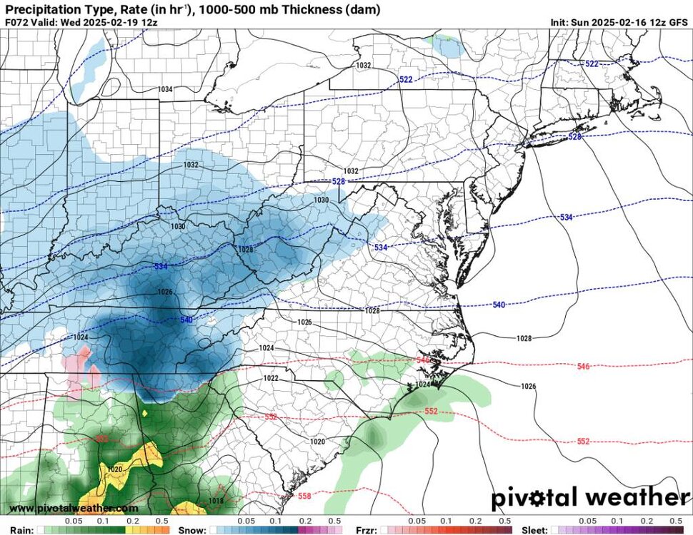
Then upslope snow on the backside. Sent from my SM-G998U using Tapatalk
.thumb.jpg.9cc1a318e1b2ab4b396887cf68e7fb62.jpg)
.thumb.jpg.6eaca929214a2219409d1ae3ffa3bfa7.jpg)
-
This would be a great look for WNC. Sent from my SM-G998U using Tapatalk

-
Flood advisory and winter weather advisory from Boone North.
-
Ashe-Alleghany NC-Watauga-Tazewell-Smyth-Bland-Giles-Wythe- Pulaski-Montgomery-Grayson-Carroll-Floyd-Craig-Alleghany VA-Bath- Roanoke-Botetourt-Rockbridge-Amherst-Mercer-Summers-Monroe- Eastern Greenbrier-Western Greenbrier- Including the cities of Volney, Covington, Tazewell, Duo, Independence, Lexington, Pearisburg, Floyd, Alderson, New Castle, Hinton, Galax, White Sulphur Springs, Flat Top, Boone, Sparta, Quinwood, Fincastle, Blacksburg, Hix, Marion, Buena Vista, Wytheville, Union, Bland, Rainelle, Radford, Amherst, Roanoke, Whitetop, Lewisburg, Troutdale, Pulaski, Salem, Hot Springs, Bluefield, West Jefferson, and Clifton Forge 723 PM EST Fri Feb 14 2025 ...FLOOD WATCH REMAINS IN EFFECT FROM 7 AM EST SATURDAY THROUGH SUNDAY EVENING... * WHAT...Flooding caused by excessive rainfall continues to be possible.
-
Ashe-Alleghany NC-Surry-Watauga-Wilkes-Giles-Pulaski-Montgomery- Grayson-Carroll-Floyd-Craig-Roanoke-Patrick-Franklin- Including the cities of Volney, Pearisburg, Dobson, Radford, Rocky Mount, West Jefferson, Galax, Stuart, Sparta, New Castle, Blacksburg, Salem, Troutdale, Pulaski, Roanoke, Independence, Floyd, Boone, Wilkesboro, and Whitetop 312 PM EST Fri Feb 14 2025 ...WINTER WEATHER ADVISORY IN EFFECT FROM 7 AM TO 7 PM EST SATURDAY... * WHAT...Freezing rain expected. Total ice accumulations around one tenth of an inch. * WHERE...Portions of north central and northwest North Carolina and southwest Virginia. * WHEN...From 7 AM to 7 PM EST Saturday.
-
Low of 18 this morning. Models look good for us.
-
This morning it was 51. Came home to current temp of 36. Winter is back. Lows tonight in the teens..
-
This is hardly a full gone conclusion. The pattern is volatile currently.
-
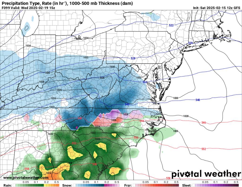
Big time storm rolled through last night. Put down a ton of rainfall. Looks like a hodgpodge of weather coming in from some freezing rain to start possibly Friday night to severe weather to snow and who knows what the 20th is going to bring.
-
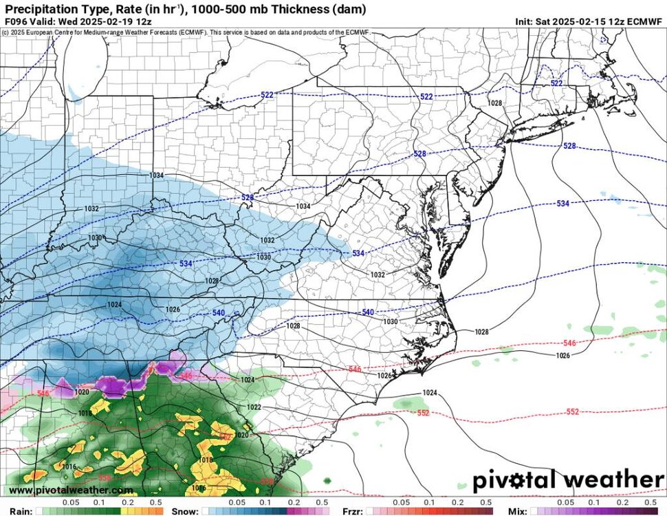
We also have upslope snow kicking back on after this next storm. Sent from my SM-G998U using Tapatalk
.thumb.jpg.3ce8e621f7c9c8fce5dfbf7bc5e28ca3.jpg)
-
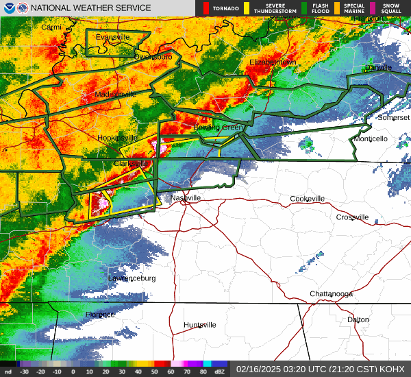
This is going to be one heck of a squall line. Going to be lots of severe storms. Sent from my SM-G998U using Tapatalk

.jpg.a0c08132b122fc2ad64876f43fee7c78.jpg)

.jpg.8fc8269ecc03b964b1fe732abbcb5568.jpg)
.jpg.c2770c9159210fc08fc9ebbfa8406fd3.jpg)
.jpg.3cc083a8cb406c65bd2f9867328db670.jpg)
.jpg.18a18261c38bb12f1b7081a712cb7cba.jpg)

.jpg.18450b265862397a20eb4330f9ebaea2.jpg)
.jpg.c6405c34ebb406ddc5aab95d827d1fe2.jpg)
.jpg.6e98a0cf382d6cca5b53e3644a5cdde4.jpg)
.jpg.dc00f22b5c8d4ebc48095074d5e5597c.jpg)